San Dieguito River facts for kids
Quick facts for kids San Dieguito River |
|
|---|---|

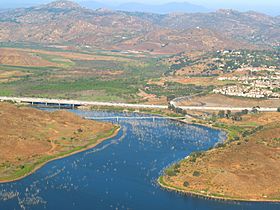
The San Dieguito River entering Lake Hodges
|
|
| Other name(s) | Rio San Bernardo |
| Country | United States |
| State | California |
| Region | Southern California |
| District | San Diego County |
| Municipality | Del Mar |
| Physical characteristics | |
| Main source | Santa Ysabel Creek |
| 2nd source | Santa Maria Creek |
| River mouth | Pacific Ocean Del Mar 0 ft (0 m) |
| Length | 24 mi (39 km), northeast-southwest |
| Basin features | |
| Basin size | 346 sq mi (900 km2) |
| Tributaries |
|
The San Dieguito River is an important river in Southern California. It starts in the Volcan Mountains in San Diego County. The river flows southwest for about 24 miles (38 km). It drains a large area of 346 square miles (896 km²). Finally, it empties into the Pacific Ocean near Del Mar. This is about 20 miles (32 km) north of the city of San Diego.
Contents
River's Journey: From Mountains to Ocean
The San Dieguito River officially begins where two smaller streams meet. These streams are called Santa Ysabel Creek and Santa Maria Creek. They join near the town of San Pasqual.
Santa Ysabel Creek
Santa Ysabel Creek starts in the northeastern part of the river's watershed. A watershed is the area of land that drains into a river. This creek flows west and forms Lake Sutherland. After leaving the lake's dam, it continues west for about 11 miles (18 km).
Santa Maria Creek
Santa Maria Creek is smaller than Santa Ysabel Creek. It begins near the city of Ramona. This creek flows north for about 7 miles (11 km). It passes through areas like the Ramona Grasslands and Bandy Canyon.
Temescal Creek
A third stream, Temescal Creek, also feeds into the river system. It starts in the Cleveland National Forest near Lake Henshaw. Temescal Creek flows south for about 9 miles (14 km) before joining Santa Ysabel Creek.
Flowing Westward
From where the main streams meet, the San Dieguito River flows west. It passes by the city of Escondido. The river then goes under Interstate 15. Further along, it is held back by the Lake Hodges Dam. This dam creates Lake Hodges, a large reservoir.
Journey to the Pacific
After Lake Hodges, the river flows through the San Dieguito River Park. This park is long and narrow. The river passes by Del Mar. Near the coast, it becomes a wide tidal waterway. It also forms a 150-acre (0.61 km²) lagoon. The river then crosses under Interstate 5 and flows past the Del Mar Fairgrounds. Finally, it empties into the Pacific Ocean at Del Mar, California.
River's Home: The Watershed
The San Dieguito River watershed is a very large area. Over 83% of it is open space. This means it has lots of natural areas. Many different plants and animals live here. The types of plants change along the river. You can find pine forests in the mountains where the river starts. Further downstream, there are dry grasslands.
However, about 18% of the watershed is developed. This includes towns and cities, mostly along the coast. Around 150,000 people live in the San Dieguito River watershed. The lower part of the river sometimes has pollution. This pollution often comes from urban runoff, which is water that flows over city streets and picks up things like bacteria.
River's Past: A Look Back in Time
The San Dieguito River area has a long history.
Early Inhabitants
Long ago, a group of people called the San Dieguito tribe lived in this area. Their main villages were along the San Dieguito River. Scientists call the remains of their culture the "San Dieguito River Complex." By the 1500s, most of the river basin was part of the land of the Luiseño people.
European Explorers
In 1769, the Portolá expedition camped near the river's coast. Later, in 1776, Father Pedro Font mentioned "San Dieguillo" in his diary. This was during the De Anza Expedition. In 1778, a Native American village called San Dieguito was noted. It was under the care of the San Diego Mission.
Changing Names
After the Mission Period, the name San Dieguito was used for a large ranch. This was the Rancho San Dieguito, granted in 1845. Later, the name of this rancho was changed to Rancho Santa Fe.
River Crossings
Many roads and tracks cross over the San Dieguito River. Here are some of them, listed from the ocean towards the river's source:
- Camino Del Mar (Historic U.S. Route 101
 )
) - The Surf Line for trains like NCTD's Coaster and Amtrak Pacific Surfliner
- Jimmy Durante Boulevard
- Interstate 5
 (San Diego Freeway)
 - El Camino Real
- Via de Santa Fe (in Rancho Santa Fe)
- Bing Crosby Boulevard
- Lake Hodges Dam
- David Kreitzer Lake Hodges Bicycle Pedestrian Bridge
- Interstate 15 Lake Hodges Bridge
 (Escondido Freeway)
 | John T. Biggers |
 | Thomas Blackshear |
 | Mark Bradford |
 | Beverly Buchanan |

