San Lucas, California facts for kids
Quick facts for kids
San Lucas, California
|
|
|---|---|

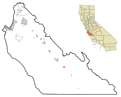
Location in Monterey County and the state of California
|
|
| Country | |
| State | |
| County | Monterey |
| Area | |
| • Total | 0.394 sq mi (1.021 km2) |
| • Land | 0.394 sq mi (1.021 km2) |
| • Water | 0 sq mi (0 km2) 0% |
| Elevation | 410 ft (125 m) |
| Population
(2020)
|
|
| • Total | 324 |
| • Density | 822.3/sq mi (317.3/km2) |
| Time zone | UTC-8 (PST) |
| • Summer (DST) | UTC-7 (PDT) |
| ZIP code |
93954
|
| Area code(s) | 831 |
| FIPS code | 06-68140 |
| GNIS feature ID | 0248896 |
San Lucas is a small community in Monterey County, California, United States. It's called a census-designated place (CDP) because it's a community that the government counts for population, but it's not officially a city. The name "San Lucas" comes from Spanish and means "Saint Luke".
This community was started in 1886. It got its name from a large piece of land called the Rancho San Lucas, which was given out in 1842. San Lucas is located in the Salinas Valley, near the Salinas River. It is about 8 miles (13 km) southeast of King City. The land here is about 410 feet (125 meters) above sea level.
In 2020, the population of San Lucas was 324 people. This was a bit more than the 269 people counted in 2010.
Contents
History of San Lucas
San Lucas began to grow when the Southern Pacific Railroad arrived in 1886. The railroad named the place after the old Rancho San Lucas land grant. A post office was opened in San Lucas in 1887. It had been moved from a nearby place called Griswold.
Geography of San Lucas
San Lucas is found in the southeastern part of Monterey County. It sits on the east side of the Salinas Valley. The community's exact location is 36°07′44″N 121°01′14″W / 36.12889°N 121.02056°W.
Major Roads and Nearby Cities
U.S. Route 101 runs right next to the western edge of San Lucas. This highway can take you about 8 miles (13 km) northwest to King City. It also goes about 55 miles (89 km) northwest to Salinas, which is the main city of the county. If you go southeast on Route 101, you'll reach Paso Robles, about 42 miles (68 km) away.
California State Route 198 starts in San Lucas and heads east. This road crosses the San Andreas Rift Zone and the Diablo Range. It leads about 48 miles (77 km) to Coalinga.
Land Area
The total area of San Lucas is about 0.4 square miles (1.0 square kilometers). All of this area is land, with no water.
Wine Region
The San Lucas AVA is a special area nearby. AVA stands for "American Viticultural Area." This means it's a recognized region where grapes are grown for making wine.
Climate in San Lucas
San Lucas has a type of weather called a warm-summer Mediterranean climate. This is often written as "Csb" on climate maps. In this kind of climate, the summers are warm and dry. The temperatures usually don't get too hot, staying below 71.6 °F (22 °C) on average in the warmest months.
Population and People
San Lucas is a small community with a changing population.
Population in 2010
In 2010, the population of San Lucas was 269 people. All of these people lived in homes, not in group living places. There were 67 households in total. Many households, about 56.7%, had children under 18 living there. The average number of people in each household was about 4.01.
The population included people of different ages. About 32.3% were under 18 years old. About 14.1% were between 18 and 24 years old. People aged 25 to 44 made up 27.5% of the population. About 4.5% of the people were 65 years or older. The average age in San Lucas was 26.3 years.
Population in 2020
By 2020, the population of San Lucas had grown to 324 people. This shows a small increase in the number of residents over ten years. The community is home to people from many different backgrounds.
See also
 In Spanish: San Lucas (California) para niños
 | Sharif Bey |
 | Hale Woodruff |
 | Richmond Barthé |
 | Purvis Young |


