Sanders, Arizona facts for kids
Quick facts for kids
Sanders, Arizona
|
|
|---|---|

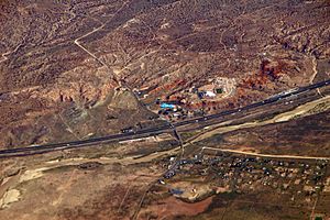
Sanders and I-40 from the air
|
|
| Country | United States |
| State | Arizona |
| County | Apache |
| Area | |
| • Total | 2.59 sq mi (6.71 km2) |
| • Land | 2.59 sq mi (6.70 km2) |
| • Water | 0.00 sq mi (0.00 km2) |
| Elevation | 5,866 ft (1,788 m) |
| Population
(2020)
|
|
| • Total | 575 |
| • Density | 222.18/sq mi (85.78/km2) |
| Time zone | UTC-7 (MST) |
| • Summer (DST) | UTC-7 (MST) |
| ZIP code |
86512
|
| FIPS code | 04-63050 |
| GNIS feature ID | 2582858 |
Sanders (which is called Łichííʼ Deezʼáhí in the Navajo language) is a small community in Apache County, Arizona, United States. It's not a full city, but a special kind of place called a census-designated place (CDP). Sanders is easy to find because it's right where two big roads meet: U.S. Route 191 and Interstate 40. In 2020, about 575 people lived there.
Contents
A Look Back: The History of Sanders
Sanders got its English name from either C.W. Sanders, who worked for the railroad, or Art Saunders, who ran a local store called a trading post. The railroad station here was actually called Cheto. This was to avoid mixing it up with another station named Sanders already on the train line.
Sanders and the Old Roads
Sanders is located close to Interstate 40 and the BNSF Railway, which is a big train track. The famous old Route 66 also runs nearby. You can still see parts of this historic highway today.
The area around Sanders is part of the Navajo Nation. Specifically, it's surrounded by the Nahata Dziil and Houck chapters of the Navajo Nation. The Houck chapter includes local Navajo people and those who moved there because of a land disagreement between the Navajo and Hopi tribes. Many Navajo families moved to the Sanders area from the western Navajo Nation due to this. Before 1981, this land was mostly used for ranching. Then, the U.S. government bought it and added it to the Navajo Nation.
Exploring the Geography of Sanders
Sanders is found at Exit 339 on Interstate 40. If you travel west on I-40, it's about 6 miles (10 km) to Chambers. Holbrook is about 53 miles (85 km) west, and Gallup, New Mexico, is about 44 miles (71 km) east. U.S. Route 191 goes south from Sanders for about 54 miles (87 km) to St. Johns.
Land Area and Natural Features
According to the United States Census Bureau, the Sanders community covers a total area of about 2.4 square miles (6.2 square kilometers). All of this area is land. Sanders sits on the southern edge of the Defiance Plateau. It's also next to the Puerco River, and you can see Puerco Ridge to the south.
Plants and Animals Around Sanders
The plants in this region include juniper trees and pinón pine trees. You can also find many native plants like prickly pear cactus and sagebrush.
Many different animals live in the area around Sanders. You might see pronghorn, mule deer, elk, and even mountain lions. Other animals include black bears, Mexican gray wolves, coyotes, and turkeys.
Understanding the Climate in Sanders
Sanders has a cold semi-arid climate. This means it gets some rain, but not a lot, and it has dry periods. Winters are cold, and summers are hot.
| Climate data for Sanders, Arizona (1991–2020 normals, extremes 1949–1956 and 1965–present) | |||||||||||||
|---|---|---|---|---|---|---|---|---|---|---|---|---|---|
| Month | Jan | Feb | Mar | Apr | May | Jun | Jul | Aug | Sep | Oct | Nov | Dec | Year |
| Record high °F (°C) | 72 (22) |
74 (23) |
86 (30) |
86 (30) |
96 (36) |
102 (39) |
107 (42) |
101 (38) |
100 (38) |
90 (32) |
79 (26) |
77 (25) |
107 (42) |
| Mean daily maximum °F (°C) | 47.8 (8.8) |
52.4 (11.3) |
60.2 (15.7) |
67.7 (19.8) |
77.1 (25.1) |
87.6 (30.9) |
90.4 (32.4) |
88.0 (31.1) |
81.9 (27.7) |
70.3 (21.3) |
58.3 (14.6) |
48.1 (8.9) |
69.1 (20.6) |
| Daily mean °F (°C) | 33.3 (0.7) |
37.4 (3.0) |
43.1 (6.2) |
49.3 (9.6) |
57.5 (14.2) |
66.9 (19.4) |
73.3 (22.9) |
71.9 (22.2) |
65.0 (18.3) |
53.4 (11.9) |
42.0 (5.6) |
33.6 (0.9) |
52.2 (11.2) |
| Mean daily minimum °F (°C) | 18.9 (−7.3) |
22.3 (−5.4) |
25.9 (−3.4) |
30.9 (−0.6) |
38.0 (3.3) |
46.2 (7.9) |
56.2 (13.4) |
55.7 (13.2) |
48.2 (9.0) |
36.5 (2.5) |
25.6 (−3.6) |
19.1 (−7.2) |
35.3 (1.8) |
| Record low °F (°C) | −23 (−31) |
−22 (−30) |
−15 (−26) |
5 (−15) |
14 (−10) |
25 (−4) |
35 (2) |
32 (0) |
20 (−7) |
7 (−14) |
−18 (−28) |
−20 (−29) |
−23 (−31) |
| Average precipitation inches (mm) | 0.89 (23) |
0.38 (9.7) |
0.70 (18) |
0.41 (10) |
0.32 (8.1) |
0.11 (2.8) |
1.17 (30) |
1.38 (35) |
0.53 (13) |
0.86 (22) |
0.70 (18) |
0.71 (18) |
8.16 (207) |
| Average snowfall inches (cm) | 0.8 (2.0) |
0.7 (1.8) |
0.7 (1.8) |
0.0 (0.0) |
0.0 (0.0) |
0.0 (0.0) |
0.0 (0.0) |
0.0 (0.0) |
0.0 (0.0) |
0.0 (0.0) |
0.3 (0.76) |
1.1 (2.8) |
3.6 (9.1) |
| Average precipitation days (≥ 0.01 inch) | 2.5 | 1.5 | 2.6 | 1.2 | 1.6 | 0.7 | 5.1 | 5.2 | 3.7 | 2.2 | 1.7 | 1.8 | 29.8 |
| Average snowy days (≥ 0.1 inch) | 0.6 | 0.3 | 0.2 | 0.0 | 0.0 | 0.0 | 0.0 | 0.0 | 0.0 | 0.0 | 0.2 | 0.4 | 1.7 |
| Source: NOAA | |||||||||||||
Who Lives in Sanders: Demographics
| Historical population | |||
|---|---|---|---|
| Census | Pop. | %± | |
| 2010 | 630 | — | |
| 2020 | 575 | −8.7% | |
| U.S. Decennial Census | |||
In 2010, there were 630 people living in Sanders. By 2020, the population was 575 people. There were 200 households, and 151 of these were families.
Population Makeup
Most people in Sanders are Native American, making up about 71.4% of the population. About 22.7% are White. A small number of people are from other backgrounds, including Black or African American, Asian, and Native Hawaiian or Pacific Islander. About 3.8% of the people are Hispanic or Latino.
Households and Families
In 2010, nearly half of the households (48.5%) had children under 18 living there. About 44.5% of households were married couples. Some households (25%) had a female head with no husband present. The average household had about 3.15 people, and the average family had about 3.71 people.
Age Groups
Sanders has a young population. About 37.1% of the people are under 18 years old. About 9.7% are between 18 and 24. People aged 25 to 44 make up 24% of the population. About 21.3% are between 45 and 64, and 7.8% are 65 or older. The average age in Sanders is about 26.8 years.
Learning in Sanders: Education
The Sanders Unified School District manages education in the community. Young students attend Sanders Elementary School, which teaches children from kindergarten to grade 5. Sanders Middle School serves students from grades 6 to 8. For high school, students go to Valley High School. The elementary and middle schools are on federal land, while the high school is on land belonging to the Navajo Nation.
Getting Around: Infrastructure and Transportation
Roads and Highways
Sanders is located right off Interstate 40, which is a major highway running east to west. U.S. Route 191 also passes through the town, running from south to north. These roads make it easy to travel to and from Sanders.
Public Transport Options
The Navajo Transit System provides public transportation in Sanders. They run a local bus route on weekdays. This bus connects the Nahata Dziil Chapter House to Window Rock, helping people get around the area.
See also
 In Spanish: Sanders (Arizona) para niños
 | Valerie Thomas |
 | Frederick McKinley Jones |
 | George Edward Alcorn Jr. |
 | Thomas Mensah |


