
Santa Anita Creek facts for kids
Quick facts for kids Santa Anita Creek |
|
|---|---|
.jpg)
The creek near the First Water trail junction
|
|
| Other name(s) | Big Santa Anita Creek, Santa Anita Wash |
| Country | United States |
| State | California |
| Region | Los Angeles County |
| Cities | Sierra Madre, Arcadia, Monrovia, Azusa, Irwindale |
| Physical characteristics | |
| Main source | Eastern flank of Mount Wilson Angeles National Forest, San Gabriel Mountains 4,600 ft (1,400 m) |
| River mouth | Rio Hondo Irwindale, San Gabriel Valley 320 ft (98 m) 34°06′12″N 118°00′56″W / 34.10333°N 118.01556°W |
| Length | 10.4 mi (16.7 km), North-south |
| Basin features | |
| River system | Rio Hondo |
| Basin size | 15 sq mi (39 km2) |
| Tributaries |
|
Santa Anita Creek is a stream in Los Angeles County, California. It is about 10.4-mile (16.7 km) long. On some maps, it is called Santa Anita Wash.
The creek starts high up in the San Gabriel Mountains. It flows south and helps form the beginning of the Rio Hondo. This happens near the city of Irwindale.
Contents
Journey of Santa Anita Creek
Where the Creek Begins
Santa Anita Creek starts on the eastern side of Mount Wilson. This area is part of the Angeles National Forest. The creek flows in a curve through Santa Anita Canyon.
Waterfalls and Other Creeks
As it flows, the creek drops over a 60-foot (18 m) waterfall called Sturtevant Falls. A little above these falls, the North Fork Santa Anita Creek joins in. The East Fork Santa Anita Creek also adds its water a bit downstream.
The creek then flows past about 80 old cabins located on the canyon floor. Further along, Winter Creek joins the Santa Anita Creek near Chantry Flat. Soon after, the creek tumbles over Hermit Falls. It then flows into the Santa Anita Reservoir, which is held back by the 225-foot (69 m) Santa Anita Dam.
Flowing Through Cities
After leaving the mountains, the creek continues south. It flows through cities like Sierra Madre, Monrovia, and Arcadia. In these areas, it is often called the Santa Anita Wash. It flows inside a concrete channel to control floods.
The creek then turns southeast towards Azusa. At Irwindale, it turns south again. Here, it empties into a small basin designed to control floodwaters.
Becoming the Rio Hondo
Water from this basin then flows out as the Rio Hondo. The Rio Hondo continues south. It eventually joins with the San Gabriel River and later the Los Angeles River.
Images for kids
-
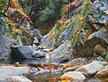
The creek near the First Water trail junction
