Santa Cruz del Quiché facts for kids
Quick facts for kids
Santa Cruz del Quiché
|
|
|---|---|
|
Municipality
|
|

Santa Cruz del Quiché, 2007
|
|
| Country | |
| Department | |
| Municipality | Santa Cruz del Quiché |
| Government | |
| • Type | Municipal |
| Area | |
| • Municipality | 271 km2 (105 sq mi) |
| Elevation | 2,021 m (6,631 ft) |
| Highest elevation | 2,500 m (8,200 ft) |
| Lowest elevation | 1,500 m (4,900 ft) |
| Population
(Census 2018)
|
|
| • Municipality | 78,279 |
| • Density | 288.9/km2 (748.1/sq mi) |
| • Urban | 78,279 |
| • Ethnicities | K'iche' Ladino |
| • Religions | Roman Catholicism Evangelicalism Maya |
| Climate | Cwb |
| Website | http://www.inforpressca.com/quiche/ |
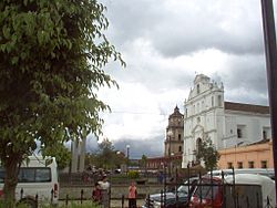
Santa Cruz del Quiché is a city in Guatemala. In 2018, about 78,279 people lived there. It's the main city of the El Quiché department and the center of its municipality. The city is high up, about 2,021 meters (6,631 feet) above sea level. It even has its own airport, Quiché Airport, just south of the city.
Contents
History of Santa Cruz del Quiché
Santa Cruz del Quiché was started by Pedro de Alvarado. He was a leader who worked with conquistador Hernán Cortés. Alvarado founded the city after burning down the nearby Maya capital city of Q'umarkaj. This city was also known as Utatlán in the Nahuatl language.
The oldest buildings in Santa Cruz del Quiché, like a big cathedral and a clock tower in the main square, were built using stones from the ruins of Q'umarkaj. These buildings were made by the Dominicans. Some people believe that the Popol Vuh, a very important sacred text of the Maya, was written down in Santa Cruz. It was written by a group of anonymous K'iche' nobles. After the city was founded, the former rulers of Q'umarkaj became peasants.
Peaceful Conversion by Dominican Friars

In 1537, a friar named Bartolomé de las Casas visited Guatemala. He wanted to try a new way to convert people to Christianity. His ideas were:
- Teach the Gospel to everyone and treat them as equals.
- Make sure people chose to convert willingly, understanding the faith.
Las Casas wanted to test this method without interference from other colonists. So, he chose a part of Guatemala where there were no colonies and where the native people were known to be strong and warlike. The governor of Guatemala, Alonso de Maldonado, agreed to let Las Casas try. He promised not to set up any new encomiendas (a system where Spanish settlers were given control over native labor) in the area if the plan worked.
Las Casas and his group of friars started Dominican churches in Rabinal, Sacapulas, and Cobán. They even reached Chahal. Because of their efforts, the area once called the "Land of War" became known as "Verapaz", meaning "True Peace".
Las Casas's plan was to teach Christian songs to Native American merchants who were already Christians. These merchants then traveled into the area and shared the songs. This helped convert several native chiefs, including those from Atitlán and Chichicastenango. Many churches were built in the territory now called Alta Verapaz. These churches brought together groups of Christian Native Americans in places like what is now the town of Rabinal.
Spanish Colonial Rule and Doctrines
After the Spanish conquest, the Spanish rulers wanted to teach the native people the Catholic faith. New settlements started by missionaries were called "Indian doctrines" or "doctrines." At first, friars were supposed to teach Catholicism and Spanish, then hand over these settlements to regular church parishes.
However, this plan didn't quite work out. The friars, protected by special permissions to convert natives, answered only to their own religious leaders, not to the Spanish government or bishops. Once a doctrine was set up, the friars often protected their own interests. This meant the doctrines became Native American towns that stayed mostly the same throughout the Spanish colonial period.
These doctrines were often run by a group of friars. This helped make sure the community system continued smoothly even if one friar passed away. In 1638, the Order of Preachers divided their large doctrines into groups around their six monasteries. One of these was the Sacapulas monastery, which included Santa Cruz del Quiché.
| Monastery | Doctrines |
|---|---|
| Sacapulas |
|
In 1754, as part of changes made by the Spanish government, the Order of Preachers had to give all their doctrines and monasteries to the regular church clergy.
Modern Times and the Pan-American Highway
In the 20th century, the important Pan-American Highway was built, but it passed by Santa Cruz del Quiché. This meant Santa Cruz became less of a main entry point to the Western Highlands. It was mostly just a stop on the way to the north of El Quiché.
Life for the Indigenous people in Santa Cruz was very difficult. Because of this, the town of Santo Tomás Chichicastenango, about 20 miles south of Santa Cruz, grew quickly. Many displaced Maya people moved there. Soon, Chichicastenango became bigger and more important than Santa Cruz.
Guatemalan Civil War Impact
During the Guatemalan Civil War, Santa Cruz del Quiché was in an area where a group called the Ejército Guerrillero de los Pobres (EGP) was active. This group sometimes damaged public and private buildings. They said this was to hurt the government and make the Guatemalan Army weaker.
For example, the EGP caused power outages in Santa Cruz del Quiché and nearby towns in November and December 1981, and again in January 1982. They also destroyed bridges to stop the Army from moving around.
The Army Base outside Santa Cruz del Quiché was a very important place for military operations. From here, the army controlled lands to the north. This area was known for supporting farmer unions and new religious ideas. Many military actions during the intense fighting from 1977 to 1984 were planned from this base. This included controlling the Ixil Triangle and setting up "model villages" near Nebaj.
During the war, some communities experienced terrible events, especially during large military operations with air support. Airplanes bombed certain areas. After such attacks, many people who survived would leave their homes. They would go into the mountains, flee to Mexico, or move to another community. The Maya K'iche' people who hid in the mountains were often called "guerrillas" by the Army. This led to strict military controls and continuous attacks, making it very hard for them to find food or medical help. Many people died from hunger.
Climate
Santa Cruz del Quiché has a subtropical highland climate. This means it has mild temperatures and a good amount of rain, especially during certain times of the year.
| Climate data for Santa Cruz del Quiché | |||||||||||||
|---|---|---|---|---|---|---|---|---|---|---|---|---|---|
| Month | Jan | Feb | Mar | Apr | May | Jun | Jul | Aug | Sep | Oct | Nov | Dec | Year |
| Mean daily maximum °C (°F) | 21.0 (69.8) |
22.3 (72.1) |
23.6 (74.5) |
24.6 (76.3) |
24.4 (75.9) |
22.8 (73.0) |
22.6 (72.7) |
23.2 (73.8) |
22.9 (73.2) |
22.4 (72.3) |
22.1 (71.8) |
21.3 (70.3) |
22.8 (73.0) |
| Daily mean °C (°F) | 15.1 (59.2) |
15.8 (60.4) |
17.0 (62.6) |
18.2 (64.8) |
18.9 (66.0) |
18.2 (64.8) |
17.6 (63.7) |
17.5 (63.5) |
17.6 (63.7) |
17.2 (63.0) |
16.2 (61.2) |
15.3 (59.5) |
17.1 (62.7) |
| Mean daily minimum °C (°F) | 9.3 (48.7) |
9.4 (48.9) |
10.5 (50.9) |
11.9 (53.4) |
13.4 (56.1) |
13.6 (56.5) |
12.7 (54.9) |
11.9 (53.4) |
12.3 (54.1) |
12.1 (53.8) |
10.3 (50.5) |
9.3 (48.7) |
11.4 (52.5) |
| Average precipitation mm (inches) | 1 (0.0) |
1 (0.0) |
9 (0.4) |
25 (1.0) |
72 (2.8) |
242 (9.5) |
179 (7.0) |
162 (6.4) |
186 (7.3) |
116 (4.6) |
34 (1.3) |
1 (0.0) |
1,028 (40.3) |
| Source: Climate-Data.org | |||||||||||||
Geographic Location
Santa Cruz del Quiché is surrounded by other towns and areas in the department of El Quiché:
 |
San Bartolomé Jocotenango | San Bartolomé Jocotenango | San Andrés Sajcabajá |  |
| San Pedro Jocopilas, San Antonio Ilotenango | Chinique, Chiché | |||
| Patzité | Chichicastenango | Chiché |
See also
 In Spanish: Santa Cruz del Quiché para niños
 | Tommie Smith |
 | Simone Manuel |
 | Shani Davis |
 | Simone Biles |
 | Alice Coachman |


