
Sarlat-la-Canéda facts for kids
Quick facts for kids
Sarlat-la-Canéda
|
||
|---|---|---|

Sarlat old city
|
||
|
||
| Country | France | |
| Region | Nouvelle-Aquitaine | |
| Department | Dordogne | |
| Arrondissement | Sarlat-la-Canéda | |
| Canton | Sarlat-la-Canéda | |
| Intercommunality | Sarlat-Périgord noir | |
| Area
1
|
47.13 km2 (18.20 sq mi) | |
| Population
(2012)
|
9,414 | |
| • Density | 199.75/km2 (517.34/sq mi) | |
| Demonym(s) | Sarladais | |
| Time zone | UTC+01:00 (CET) | |
| • Summer (DST) | UTC+02:00 (CEST) | |
| INSEE/Postal code |
24520 /24200
|
|
| Elevation | 102–319 m (335–1,047 ft) (avg. 211 m or 692 ft) |
|
| Website | www.sarlat.fr | |
| 1 French Land Register data, which excludes lakes, ponds, glaciers > 1 km2 (0.386 sq mi or 247 acres) and river estuaries. | ||
.svg)
Sarlat-la-Canéda is a charming town in southwestern France. People often call it simply Sarlat. It is located in the Dordogne area, which is a department (like a county) in the Aquitaine region. Sarlat-la-Canéda is an important local center, known as a sub-prefecture.
Contents
History of Sarlat
Sarlat began as a Benedictine monastery in the 9th century. A monastery is a place where monks live and work. The town grew around this religious building. By the 13th century, it was a busy center.
Early Beginnings of Sarlat
The Sarlat monastery was one of six big monasteries in the old Périgord area. The others were Paunat, Belvès, Saint Front de Périgueux, Brantôme, and Terrasson. Sarlat was special because it was not near the Dordogne River or its smaller rivers. This helped protect it from Vikings who often traveled by boat.
Sarlat Becomes a Bishop's Seat
In 1317, Sarlat became the home of a bishop. This meant it was an even more important religious center.
Rebuilding After War
The town was badly damaged during the Hundred Years' War. This was a long conflict between England and France. After the war, Sarlat was rebuilt. Many buildings were created in the beautiful Renaissance style between 1450 and 1500.
Modern Sarlat-la-Canéda
On March 1, 1965, the towns of Sarlat and La Canéda joined together. They formed one larger town called Sarlat-la-Canéda.
Geography of Sarlat
Sarlat-la-Canéda covers an area of about 47.13 square kilometers (18.2 square miles). The town is located at an average height of 211 meters (692 feet) above sea level. The town hall itself is at 129 meters (423 feet).
Neighboring Towns of Sarlat
Sarlat-la-Canéda is surrounded by several other towns. These include Tamniès, Marquay, Marcillac-Saint-Quentin, Proissans, Sainte-Nathalène, Saint-Vincent-le-Paluel, Carsac-Aillac, Vitrac, Vézac, and Saint-André-d'Allas.

 |
Tamniès Marquay |
Marcillac-Saint-Quentin | Proissans | |
| Saint-André-d'Allas | Sainte-Nathalène Saint-Vincent-le-Paluel |
|||
| Vézac | Vitrac | Carsac-Aillac |
Population of Sarlat
Sarlat-la-Canéda has a population of 9,414 people. This means there are about 200 people living in each square kilometer of the town.
Who are the Sarladais?
The people who live in Sarlat-la-Canéda are called Sarladais in French. If you are talking about a woman from Sarlat, you would say Sarladaise.
Administration of Sarlat
Sarlat-la-Canéda has been an important administrative center since 1790. It is a sous-préfecture in the Dordogne department. This means it is a key government office for the area. The town is also part of the canton of Sarlat-la-Canéda. A canton is a smaller administrative area, and this one includes 12 other towns.
Famous People from Sarlat
Several important people were born in or lived in Sarlat-la-Canéda:
- Étienne de La Boétie (1530-1563), a well-known lawyer and writer.
- Gautier de Costes de La Calprenède (about 1610-1663), another famous writer.
- Pierre Lachambeaudie (1807-1872), a talented poet.
- Gabriel Tarde (1843-1904), a social scientist who studied how people behave in groups.
More About Sarlat
Images for kids
-
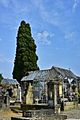
Cimetière Sarlat
-
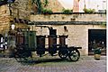
Portable still at Sarlat
-
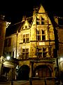
House of De La Boétie, the immortal friend of Montaigne
-
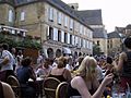
Centre of Sarlat on a summer's day


See also
 In Spanish: Sarlat-la-Canéda para niños
