Scandia, Alberta facts for kids
Quick facts for kids
Scandia
|
|
|---|---|

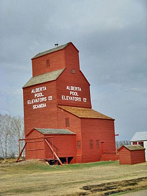
Last remaining prairie grain elevator in the Scandia district.
|
|
| Country | Canada |
| Province | Alberta |
| Region | Southern Alberta |
| Census division | 2 |
| Municipal district | County of Newell |
| Area
(2021)
|
|
| • Land | 0.19 km2 (0.07 sq mi) |
| Population
(2021)
|
|
| • Total | 169 |
| • Density | 877.9/km2 (2,274/sq mi) |
| Time zone | UTC−7 (MST) |
| • Summer (DST) | UTC−6 (MDT) |
| Postal code span |
T0J 2Z0
|
| Area code(s) | +1-403 |
| Highways | Highway 36 |
Scandia is a small community called a hamlet in Alberta, Canada. It is part of the County of Newell. You can find Scandia about 2 kilometers west of Highway 36. It is also about 34 kilometers southwest of the city of Brooks.
Contents
History of Scandia
The Railway Arrives
Scandia grew thanks to the railway. In 1927 and 1928, the Canadian Pacific Railway built a special branch line. This line connected Scandia to Cassils. The railway helped bring people and goods to the area.
People of Scandia
How Many People Live Here?
Scandia is a small but friendly place. In 2021, the community had a population of 169 people. These residents lived in 52 homes. This number was a bit higher than in 2016, when 146 people lived in Scandia. The community covers a small area of about 0.19 square kilometers.
Fun Things to Do
Scandia Eastern Irrigation District Museum
One of the main attractions in Scandia is the Scandia Eastern Irrigation District Museum. This museum helps visitors learn about the history of the area. It shows how people lived and worked in the past. It's a great place to explore and discover local heritage.
 | Georgia Louise Harris Brown |
 | Julian Abele |
 | Norma Merrick Sklarek |
 | William Sidney Pittman |


