
Schenley Farms Historic District facts for kids
|
Schenley Farms Historic District
|
|

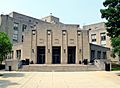
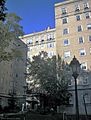
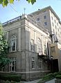
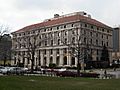
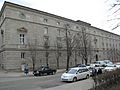
Looking Northeast along 5th Avenue in the Schenley Farms Historic District
|
|

Location in Pittsburgh

Location in Pennsylvania

Location in the United States
|
|
| Location | Roughly bounded by Andover Terrace, Centre, Bellefield, and Parkman Avenues, Dithridge, Thackeray, Forbes and Mawhinney, Pittsburgh, Pennsylvania, USA |
|---|---|
| Area | 170 acres (0.69 km2) |
| NRHP reference No. | 83002213 |
Quick facts for kids Significant dates |
|
| Added to NRHP | July 22, 1983 |
The Schenley Farms Historic District is a special area in Pittsburgh, Pennsylvania, United States. It's officially recognized as a historic district on the National Register of Historic Places. This means it has important buildings and history worth protecting.
This district is also known as the Schenley Farms–Oakland Civic District. It's located in the Oakland part of Pittsburgh. The district includes two smaller historic areas within the city. One is the Oakland Civic Center Historic District, which has many public and private buildings. The other is the Schenley Farms Historic District, which is mostly a planned neighborhood with homes.
The Schenley Farms area is roughly bordered by Forbes Avenue to the south. It includes the Carnegie Museums of Pittsburgh. To the east, it reaches South Dithridge and North Bellefield. This area also includes St. Paul's Cathedral and its Rectory on Fifth Avenue. The district extends to North Craig Street, Bigelow Boulevard, Andover Road, Bryn Mawr Road, and Thackeray Street.

Contents
What Makes Schenley Farms Special?
Schenley Farms is famous for its beautiful buildings. Many of them were built in the late 1800s and early 1900s. They show styles like the Revivals architecture. A large part of the University of Pittsburgh campus is located here.
The historic district has 154 important buildings. About 31 of these are cultural or institutional buildings. The other 123 are homes in the northwest part of the district. This area is a great example of how communities were planned. It followed ideas from the City Beautiful movement.
The City Beautiful Movement
The City Beautiful movement was a trend in city planning. It happened in the United States from the 1890s to the early 1900s. This movement focused on making cities more beautiful and organized. Planners wanted wide boulevards, lovely parks, and grand public buildings. They often used a style called Beaux-Arts.
How Schenley Farms Was Planned
In 1905, a man named Franklin Nicola created a plan for Oakland. He wanted to use the City Beautiful style. His plan included areas for civic buildings, social spaces, homes, and schools. These areas were to be along Bigelow Boulevard. This road ran through the center of the neighborhood.
Nicola's idea was to build many grand buildings. They would look like ancient Greek or Italian Renaissance structures. His full plan was not completed. For example, an Oakland town hall was never built. However, his vision led to important landmarks. These include the Soldiers and Sailors Memorial Hall. Also, the Masonic Temple, now the University of Pittsburgh's Alumni Hall, was part of this plan. The Pittsburgh Athletic Association building was also built.
Other major buildings were added later. These were built after Nicola's original plans had finished. They include the famous Cathedral of Learning. Also, the Heinz Memorial Chapel of the University of Pittsburgh is here. The Mellon Institute is another important building. The buildings in the historic district were built between 1880 and 1979.
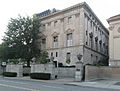
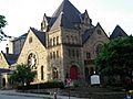
Important Buildings and Sites
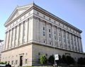
Many famous and historic buildings are found in the Schenley Farms Historic District. These buildings are important to the history and culture of Pittsburgh. Many of them are part of the University of Pittsburgh.
-
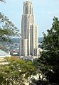
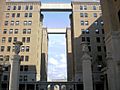
The Cathedral of Learning is the main building of the University of Pittsburgh. It is also a historic place.
-
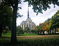
The University of Pittsburgh's Heinz Memorial Chapel is a beautiful church.
-
The former Masonic Temple is now Pitt's Alumni Hall.
-
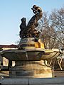
The Mary Schenley Memorial Fountain is also called A Song to Nature.
-
The former Y.M.H.A. building is now Pitt's Bellefield Hall.
-
The Stephen Foster Memorial is at the University of Pittsburgh.
-
The former Schenley Apartments are now student residences.
-
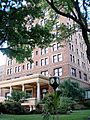
The former Schenley Hotel is now the University of Pittsburgh's William Pitt Union.
-
Clapp Hall is a building at the University of Pittsburgh.
-
The former Mellon Institute building is now Pitt's Allen Hall.
-
Thaw Hall is another building at the University of Pittsburgh.
-
The former Central Turnverein is now the Gardner Steel Conference Center at Pitt.
-
The former Ruskin Apartments are now Pitt's Ruskin Hall.
-
The former National Union Fire Insurance Company building is now Pitt's Thackeray Hall.
-
The Frick Fine Arts Building is at the University of Pittsburgh.
-
The former home of William Jacob Holland is now the Music Building at Pitt.
-
The University Club is now a building on Pitt's campus.
-
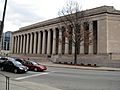
The Carnegie Institute includes several museums.
-
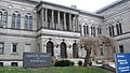
The Carnegie Library of Pittsburgh is part of the Carnegie Institute.
-
The Mellon Institute is a famous research building.
-
The Pittsburgh Athletic Association building is a landmark.
-
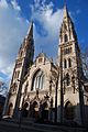
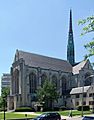
St. Paul's Cathedral is a large church.
-
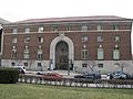
The former Schenley High School closed in 2008.
-
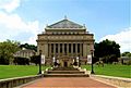
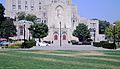
Soldiers and Sailors Memorial Hall honors veterans.
-
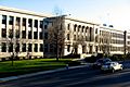
The Pittsburgh Public School's Board of Education building.
-
The Twentieth Century Club.
-
Bellefield Presbyterian Church.
-
First Baptist Church.


