
Shannon–Erne Waterway facts for kids
Quick facts for kids Shannon–Erne WaterwayUiscebhealach na Sionainne is na hÉirne |
|
|---|---|

Castlefore Lock on the Shannon–Erne Waterway
|
|
| Specifications | |
| Length | 63 km (39 miles) |
| Locks | 16 |
| Status | Open |
| Navigation authority | Waterways Ireland |
| History | |
| Date of first use | 1860 |
| Date closed | 1870 |
| Date restored | 1994 |
| Geography | |
| Start point | Upper Lough Erne |
| End point | Leitrim |
| Connects to | River Shannon (Lough Allen Canal) |
The Shannon–Erne Waterway (Irish: Uiscebhealach na Sionainne is na hÉirne) is a canal that connects two big rivers. It links the River Shannon in the Republic of Ireland with the River Erne in Northern Ireland. This waterway is managed by Waterways Ireland.
The canal is about 63 kilometers (39 miles) long. It has sixteen special gates called locks that help boats move between different water levels. The waterway stretches from Leitrim village in County Leitrim to Upper Lough Erne in County Fermanagh. The Shannon–Erne Waterway officially opened on May 23, 1994.
Contents
History of the Waterway
The Shannon–Erne Waterway has a long and interesting history. Its earliest known name was the River Gráinne. This name means 'The Gravelly River' in Irish. Old poems and historical records from the 1200s and 1400s mention this river.
After the 1650s, the river was renamed the Woodford River. This name came from the Woodford Demesne in County Leitrim. Later, when the river was made into a canal in the 1850s, it was called the Woodford Canal. Sometimes, people also called it the Ballinamore and Ballyconnell Canal.
Early Plans for a Link
People dreamed of connecting the Erne and Shannon rivers for a long time. The first attempt to link them happened in 1780. Richard Evans started this work, but he couldn't get enough money to finish it. In 1790, there was another plan to connect Lower Lough Erne to the sea. This project also failed because not enough money was raised.
In 1793, engineer William Chapman looked at the Woodford River. He thought it would cost about £5,000 to reach Garadice Lough. From there, he believed a link to the Shannon was possible. But nothing happened for many years.
Building the Canal
In 1831, a government group called the Office of Public Works (OPW) was created. One of their jobs was to find projects that would create jobs. They asked William Mulvany to survey the area. At this time, another canal, the Ulster Canal, was being built to connect to Lough Neagh.
Local landowners wanted better drainage for their land. The Ulster Canal wanted the link to the Shannon finished. These two reasons convinced the OPW to act. They decided to combine a navigation project (for boats) with a drainage project (to remove excess water). John McMahon, an engineer, drew up the plans. He estimated the work would cost £100,000.
Work on the Ballinamore and Ballyconnell Canal began in 1846. The OPW paid for it. John McMahon planned the route, and William Mulvany was the engineer in charge. It was tricky because drainage needs low water levels, but boats need high water levels. This made the project difficult to manage. There were also problems finding enough workers.
The canal used steam dredgers to dig channels through six lakes. Many locks were built with large weirs (dams). The project cost much more than expected. By 1859, the cost had reached over £276,000. After a public investigation, local counties and the government paid the extra money. The canal was officially handed over to managers on July 4, 1860.
Decline of the Canal
However, very few boats used the canal. Between 1860 and 1869, only eight boats used it, earning only £18 in tolls. Because of this low use, there was little reason to fix problems. By 1865, maintenance on the canal had stopped.
In 1868, a trustee named John Grey Vesey Porter traveled the canal by steamer. It took him three weeks because water had to be moved from one section to another just to keep the boat floating. He called the project "one of the most shameful pieces of mismanagement." In 1887, the Cavan and Leitrim Railway built low bridges over the canal. This showed they believed the canal would not be used for boats anymore. The railway itself also struggled.
By 1948, the groups managing the canal had stopped working. Local authorities had to take over bridge repairs. Flooding also remained a problem in the area.
A New Waterway
The canal lay unused for many years. But in the 1960s, more people started enjoying pleasure boating on the Shannon. They wondered if the old canal could be brought back to life. By 1969, local groups asked for a full study of the canal.
In 1988, a study looked into rebuilding the canal. This study was funded by the International Fund for Ireland. The canal crossed the border between the Republic of Ireland and Northern Ireland. Both governments decided to make it a major cross-border project.
Work began in November 1990. The canal was opened for boats on May 23, 1994. It was finished on time and within its budget of £30 million. It was almost like building a new waterway along the old route.
Modern Reconstruction
The project involved rebuilding many parts of the canal for modern boats. Eight locks between Lough Scur and Lough Erne were new concrete structures. They were made wider (6 meters or 19.8 feet) but covered with stone from the original locks. The other eight locks down to the Shannon were repaired and kept their original width (5 meters or 16.5 feet).
The new locks are automatic. Boat crews can operate them using a special smart card. After it was restored, the canal was renamed the Shannon–Erne Waterway. This new name shows its purpose: linking the two river systems. The canal was opened by Dick Spring, the Irish Foreign Minister, and Sir Patrick Mayhew, the Secretary of State for Northern Ireland.
One unexpected result of the project was the arrival of the zebra mussel. This is a type of mussel that is not native to the Erne river system. It traveled along the waterway from the Shannon.
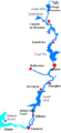
Course of the Waterway
The Shannon–Erne Waterway has three main parts:
- A calm, still-water canal section from the Shannon at Leitrim to Kilclare. This part has eight locks.
- A high "summit level" section that includes Lough Scur.
- A river navigation section from Castlefore, near Keshcarrigan, through Ballinamore and Ballyconnell to the Erne. This part has another eight locks.
Images for kids
-
Map of the River Shannon
-
Location map of Lough Erne


See also
 In Spanish: Canal Shannon-Erne para niños
