Sharkey County, Mississippi facts for kids
Quick facts for kids
Sharkey County
|
|
|---|---|

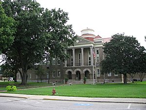
Sharkey County courthouse in Rolling Fork
|
|

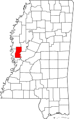
Location within the U.S. state of Mississippi
|
|
 Mississippi's location within the U.S. |
|
| Country | |
| State | |
| Founded | 1876 |
| Named for | William L. Sharkey |
| Seat | Rolling Fork |
| Largest city | Rolling Fork |
| Area | |
| • Total | 435 sq mi (1,130 km2) |
| • Land | 432 sq mi (1,120 km2) |
| • Water | 3.4 sq mi (9 km2) 0.8% |
| Population
(2020)
|
|
| • Total | 3,800 |
| • Density | 8.74/sq mi (3.37/km2) |
| Time zone | UTC−6 (Central) |
| • Summer (DST) | UTC−5 (CDT) |
| Congressional district | 2nd |
Sharkey County is a county in the state of Mississippi. The Yazoo River forms part of its eastern edge. In 2020, about 3,800 people lived here. This makes it one of the smallest counties in Mississippi by population. The main town, or county seat, is Rolling Fork. The county gets its name from William L. Sharkey, who was a temporary Governor of Mississippi way back in 1865. Sharkey County is found in the Mississippi Delta area, known for its flat land.
Contents
Historic Weather Events
Sharkey County has experienced some powerful storms. On February 21, 1971, a very strong F5 tornado hit parts of the county.
More recently, on March 24, 2023, a powerful EF4 tornado struck the city of Rolling Fork. This tornado had winds estimated at 195 mph (314 kph). It caused a lot of damage in the community. Sadly, this tornado led to 17 deaths and 165 injuries.
Geography of Sharkey County
Sharkey County covers a total area of about 435 square miles. Most of this area, 432 square miles, is land. Only a small part, about 3.4 square miles, is water.
Main Roads in Sharkey County
Neighboring Counties
Sharkey County shares borders with several other counties:
- Washington County (to the north)
- Humphreys County (to the northeast)
- Yazoo County (to the east)
- Issaquena County (to the southwest)
Protected Natural Areas
- Delta National Forest
- Theodore Roosevelt National Wildlife Refuge (part of it is in Sharkey County)
Population and People
| Historical population | |||
|---|---|---|---|
| Census | Pop. | %± | |
| 1880 | 6,306 | — | |
| 1890 | 8,382 | 32.9% | |
| 1900 | 12,178 | 45.3% | |
| 1910 | 15,694 | 28.9% | |
| 1920 | 14,190 | −9.6% | |
| 1930 | 13,877 | −2.2% | |
| 1940 | 15,433 | 11.2% | |
| 1950 | 12,903 | −16.4% | |
| 1960 | 10,738 | −16.8% | |
| 1970 | 8,937 | −16.8% | |
| 1980 | 7,964 | −10.9% | |
| 1990 | 7,066 | −11.3% | |
| 2000 | 6,580 | −6.9% | |
| 2010 | 4,916 | −25.3% | |
| 2020 | 3,800 | −22.7% | |
| 2023 (est.) | 3,336 | −32.1% | |
| U.S. Decennial Census 1790-1960 1900-1990 1990-2000 2010-2013 |
|||
In 2020, the county had 3,800 residents. There were 1,751 households and 1,046 families living there. Most people in Sharkey County are African American (about 70%). About 25% are White.
Education in Sharkey County
Students in Sharkey County attend schools run by public school districts or private schools.
- Public Schools
- South Delta School District, which includes South Delta High School
- Private Schools
- Sharkey-Issaquena Academy in Rolling Fork
Communities in Sharkey County

City
- Rolling Fork (This is the county seat, meaning it's where the county government is located.)
Towns
Census-Designated Places
These are areas that are like towns but are not officially incorporated as cities or towns.
Unincorporated Communities
These are small communities that are not part of any city or town.
 |
Washington County | Humphreys County |  |
|
| Issaquena County | Yazoo County | |||
| Issaquena County |
See also
 In Spanish: Condado de Sharkey (Misisipi) para niños

