Sheberghan facts for kids
Quick facts for kids
Sheberghan
شبرغان
|
|
|---|---|
|
City
|
|
| Country | |
| Province | Jowzjan Province |
| Area | |
| • City | 73 km2 (28 sq mi) |
| Elevation | 361 m (1,184 ft) |
| Population
(2022 estimate)
|
|
| • City | 98,170 |
| • Density | 1,345/km2 (3,483/sq mi) |
| • Urban | 175,599 |
| Time zone | UTC+4:30 (Afghanistan Standard Time) |
Sheberghan is a city in northern Afghanistan. It is also known as Shaburghān or shāhpurgān. You might also see it spelled Shebirghan or Shibarghan. Sheberghan is the capital city of the Jowzjan Province.
The city has about 175,599 people living there. It is divided into four main areas. The total land area of Sheberghan is about 7,335 hectares. In 2021, the Taliban took control of the city.
Contents
Where is Sheberghan Located?
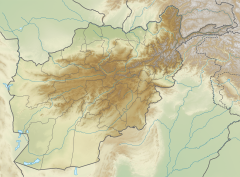
Sheberghan is found along the Sari Pul River. It is about 130 kilometers (80 miles) west of Mazar-i-Sharif. The city is on a major road that connects many important places in Afghanistan. This road links cities like Kabul, Puli Khumri, Mazar-i-Sharif, Maymana, Herat, Kandahar, Ghazni, and Maidan Shar. There is also an airport called Sheberghan airport located between Sheberghan and Aqcha.
What Does the Name Sheberghan Mean?
The name Sheberghan comes from an old Persian name, Shaporgân. This name means "Shapur's town." Shapur was the name of two ancient kings from the Sasanian Empire. These kings built many cities. It is believed that Shapur I was the one who built a road connecting several important cities, including this one.
Who Lives in Sheberghan?
Sheberghan is a city where many Uzbeks and Turkmens live. After Maymana, it is the second most important city for these groups in Afghanistan. For most people in Sheberghan, Turkmen is their first language.
Many other groups also live in the city. These include Tajiks, Hazaras, Pashtuns, and Arabs. In 1856, a traveler named J. P. Ferrier noted that Uzbeks were the largest group. Even today, Turkmens are thought to be the majority of people living there.
Some people in Sheberghan identify as "Arabs." However, they speak Persian, not Arabic. Their identity as Arabs comes from their family history. It might be linked to Arab people who moved to this area in the 7th and 8th centuries. This happened after the Islamic conquests in the region.
Sheberghan's History
Sheberghan was once a busy town along the famous Silk Road. This was an ancient trade route. In 1978, archaeologists from the Soviet Union found amazing treasures near Sheberghan. They discovered the famous Bactrian Gold in a village called Tillia Tepe.
In the 13th century, the famous explorer Marco Polo visited the city. He wrote about its very sweet melons. Later, Sheberghan became the capital of an independent Uzbek kingdom. This kingdom was given to Afghanistan in 1873 by an agreement between Britain and Russia.
Sheberghan has been an important place for a very long time. It is located on the main route between Balkh and Herat. It also controls the path north to the Amu Darya river, which is about 90 kilometers (56 miles) away. There is also an important route south to Sar-e Pol.
In 1856, J. P. Ferrier described Sheberghan. He said it had a strong fort where the governor lived. The area around the town had beautiful gardens and good farms. He noted that the people of Sheberghan were known for being brave. He called it one of the best towns in that part of Turkistan.
However, the town had a problem with its water supply. The water came from mountains in another area. Sometimes, there were fights between the groups living there and the people in Sheberghan. This could stop the water supply and even lead to wars.
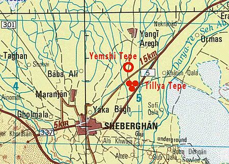
Near Sheberghan, there is an old fortified town called Yemshi-tepe. It is about 5 kilometers (3 miles) northeast of the modern city. Close by is the famous burial site of Tillya Tepe. Here, a huge treasure was found in royal tombs between 1969 and 1979. This discovery was made by a team of Soviet and Afghan archaeologists.
In 1977, another archaeological team started digging 5 kilometers north of the town. They found ancient mud-brick columns and an altar from a temple. This temple was built at least 1000 years before Christ. The six royal tombs at Tillia Tepe contained a lot of gold and other valuable items. Some coins found were from the early 1st century CE.
Sheberghan is believed to be the site of an ancient city called Xidun. This was one of the five main areas of the early Kushan Empire.
In the early 2000s, Sheberghan was a strong base for a local Uzbek leader named Abdul Rashid Dostum. He was a powerful figure in northern Afghanistan. In December 2001, during the U.S. invasion of Afghanistan, an event known as the Dasht-i-Leili massacre occurred. During this time, many Taliban prisoners were being moved from Kunduz to a prison in Sheberghan by American and Northern Alliance soldiers. Tragically, many of these prisoners died during the transfer.
On August 7, 2021, Taliban forces took control of Sheberghan. This was part of their larger military actions across Afghanistan.
How is the Land Used in Sheberghan?
Sheberghan is a center for trade and travel in northern Afghanistan. About half of the city's land, which is 7,335 hectares, is used for farming. About 23% of the land is used for homes. These homes are mostly in the central part of the city but are spread out across its four districts.
Sheberghan's Climate
Sheberghan has a cool, dry climate. Summers are hot, and winters are cold, but the temperature can change a lot. There is some rain and snow from January to March. However, the rest of the year is dry, especially in the summer months.
| Climate data for Sheberghan | |||||||||||||
|---|---|---|---|---|---|---|---|---|---|---|---|---|---|
| Month | Jan | Feb | Mar | Apr | May | Jun | Jul | Aug | Sep | Oct | Nov | Dec | Year |
| Record high °C (°F) | 22.4 (72.3) |
24.2 (75.6) |
30.9 (87.6) |
35.4 (95.7) |
41.5 (106.7) |
46.0 (114.8) |
47.5 (117.5) |
44.3 (111.7) |
40.6 (105.1) |
36.4 (97.5) |
30.6 (87.1) |
25.6 (78.1) |
47.5 (117.5) |
| Mean daily maximum °C (°F) | 6.8 (44.2) |
9.3 (48.7) |
15.8 (60.4) |
23.7 (74.7) |
31.1 (88.0) |
36.9 (98.4) |
38.9 (102.0) |
37.2 (99.0) |
32.0 (89.6) |
24.0 (75.2) |
16.7 (62.1) |
10.6 (51.1) |
23.6 (74.5) |
| Daily mean °C (°F) | 2.0 (35.6) |
4.9 (40.8) |
10.5 (50.9) |
17.3 (63.1) |
23.2 (73.8) |
28.8 (83.8) |
31.0 (87.8) |
28.6 (83.5) |
23.1 (73.6) |
16.4 (61.5) |
10.0 (50.0) |
5.4 (41.7) |
16.8 (62.2) |
| Mean daily minimum °C (°F) | −1.3 (29.7) |
1.3 (34.3) |
5.7 (42.3) |
11.5 (52.7) |
15.1 (59.2) |
19.4 (66.9) |
22.2 (72.0) |
20.0 (68.0) |
15.1 (59.2) |
9.8 (49.6) |
4.6 (40.3) |
1.5 (34.7) |
10.4 (50.7) |
| Record low °C (°F) | −20.5 (−4.9) |
−25.7 (−14.3) |
−9.4 (15.1) |
−7.5 (18.5) |
5.3 (41.5) |
8.5 (47.3) |
12.9 (55.2) |
11.6 (52.9) |
4.3 (39.7) |
−2.4 (27.7) |
−8.5 (16.7) |
−15.0 (5.0) |
−25.7 (−14.3) |
| Average precipitation mm (inches) | 42.3 (1.67) |
44.3 (1.74) |
56.4 (2.22) |
25.9 (1.02) |
11.2 (0.44) |
0.2 (0.01) |
0.0 (0.0) |
0.0 (0.0) |
0.2 (0.01) |
6.6 (0.26) |
13.6 (0.54) |
29.8 (1.17) |
230.5 (9.08) |
| Average rainy days | 5 | 6 | 9 | 6 | 3 | 0 | 0 | 0 | 0 | 2 | 3 | 4 | 38 |
| Average snowy days | 5 | 3 | 1 | 0 | 0 | 0 | 0 | 0 | 0 | 0 | 1 | 2 | 12 |
| Average relative humidity (%) | 78 | 76 | 71 | 65 | 47 | 34 | 31 | 32 | 35 | 46 | 61 | 74 | 54 |
| Mean monthly sunshine hours | 115.3 | 124.1 | 162.3 | 198.2 | 297.9 | 364.3 | 365.9 | 346.1 | 304.6 | 242.9 | 175.8 | 125.7 | 2,823.1 |
| Source: NOAA (1964-1983) | |||||||||||||
Sheberghan's Economy
Sheberghan is surrounded by farmland that uses irrigation. This means water is supplied to the crops.
In 1967, with help from the Soviet Union, Afghanistan started using its natural gas. This began at the Khowaja Gogerak field, which is 15 kilometers (9 miles) east of Sheberghan. This gas field was thought to have a very large amount of gas. Also in 1967, a 100-kilometer (62-mile) gas pipeline was built. It connected a place in the Soviet Union to Sheberghan.
The United States Department of Defense spent money to build a natural gas filling station. This showed how natural gas could be used instead of expensive oil.
Sheberghan is very important for Afghanistan's energy supply:
- The Zomrad Sai Oilfield is located near the city.
- The Sheberghan Topping Plant processes crude oil. This oil is used to heat buildings in Kabul, Mazari Sharif, and Sheberghan.
- Gas fields like Jorqaduk, Khowaja Gogerak, and Yatimtaq are all within 20 kilometers (12 miles) of Sheberghan.
See also
 In Spanish: Šibarġan para niños
 | Misty Copeland |
 | Raven Wilkinson |
 | Debra Austin |
 | Aesha Ash |


