Sheridan County, Wyoming facts for kids
Quick facts for kids
Sheridan County
|
||
|---|---|---|

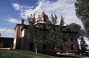
Sheridan County Courthouse
|
||
|
||

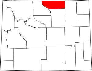
Location within the U.S. state of Wyoming
|
||
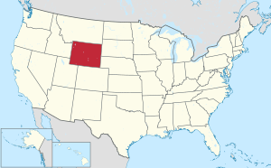
 Wyoming's location within the U.S. |
||
| Country | ||
| State | ||
| Founded | March 9, 1888 | |
| Named for | Philip Sheridan | |
| Seat | Sheridan | |
| Largest city | Sheridan | |
| Area | ||
| • Total | 2,527 sq mi (6,540 km2) | |
| • Land | 2,524 sq mi (6,540 km2) | |
| • Water | 3.1 sq mi (8 km2) 0.1%% | |
| Population
(2020)
|
||
| • Total | 30,921 | |
| • Estimate
(2023)
|
32,519 |
|
| • Density | 12.2362/sq mi (4.7244/km2) | |
| Time zone | UTC−7 (Mountain) | |
| • Summer (DST) | UTC−6 (MDT) | |
| Congressional district | At-large | |
Sheridan County is a place in the state of Wyoming, USA. It's like a big district or region within the state. In 2020, about 30,921 people lived here. The main town and center of the county is Sheridan. The northern part of Sheridan County touches the border of Montana. It's also known as the Sheridan, WY Micropolitan Statistical Area, which means it's a small city area with close ties to nearby communities.
Contents
History of Sheridan County
Sheridan County was officially created on March 9, 1888. This happened when the lawmakers of the Wyoming Territory decided to form it. The new county was made from a part of Johnson County.
Sheridan County was named after Philip Sheridan. He was a famous general during the American Civil War.
Over the years, the county's borders changed a few times. In 1897, a piece of Sheridan County was used to create Big Horn County. There were also small changes to the borders in 1911 and again in 1929. Since 1929, the county's shape has stayed the same.
Geography of Sheridan County
Sheridan County is quite large. It covers a total area of about 2,527 square miles. Most of this area, about 2,524 square miles, is land. Only a small part, about 3.1 square miles, is water. This means water makes up less than one percent of the county's total area.
Neighboring Counties
Sheridan County shares its borders with several other counties. Some are in Wyoming, and some are in Montana.
- Big Horn County, Montana – to the north
- Powder River County, Montana – to the northeast
- Campbell County – to the east
- Johnson County – to the south
- Big Horn County – to the west
Main Roads
Many important roads run through Sheridan County. These highways help people travel around the county and to other states.
 Interstate 90
 I-90 Bus.
 U.S. Highway 14
 U.S. Highway 16
 U.S. Highway 87
 Wyoming Highway 330
 Wyoming Highway 331
 Wyoming Highway 332
 Wyoming Highway 334
 Wyoming Highway 335
 Wyoming Highway 336
 Wyoming Highway 337
 Wyoming Highway 338
 Wyoming Highway 339
 Wyoming Highway 341
 Wyoming Highway 342
 Wyoming Highway 343
 Wyoming Highway 345
Public Transportation
People in Sheridan County can use public transport services.
- Goose Creek Transit
- Jefferson Lines
Protected Natural Areas
Part of a large national forest is located in Sheridan County.
- Bighorn National Forest (part)
Population of Sheridan County
The number of people living in Sheridan County has changed over many years. Here's a look at how the population has grown or shrunk since 1890:
| Historical population | |||
|---|---|---|---|
| Census | Pop. | %± | |
| 1890 | 1,972 | — | |
| 1900 | 5,122 | 159.7% | |
| 1910 | 16,324 | 218.7% | |
| 1920 | 18,182 | 11.4% | |
| 1930 | 16,875 | −7.2% | |
| 1940 | 19,255 | 14.1% | |
| 1950 | 20,185 | 4.8% | |
| 1960 | 18,989 | −5.9% | |
| 1970 | 17,852 | −6.0% | |
| 1980 | 25,048 | 40.3% | |
| 1990 | 23,562 | −5.9% | |
| 2000 | 26,560 | 12.7% | |
| 2010 | 29,116 | 9.6% | |
| 2020 | 30,921 | 6.2% | |
| 2023 (est.) | 32,519 | 11.7% | |
| US Decennial Census 1870–2000 2010–2020 |
|||
In 2010, there were 29,116 people living in the county. There were 12,360 households, which are groups of people living together. About 7,701 of these were families. The average age of people in the county was about 41.9 years old.
Towns and Communities
Sheridan County has several towns and smaller communities. These are places where people live and work.
City
- Sheridan is the largest city and the county seat. This means it's the main center for the county's government.
Towns
Census-Designated Places
These are areas that are like towns but are not officially incorporated as cities or towns.
Other Communities
These are smaller, unincorporated places in the county.
See also
 In Spanish: Condado de Sheridan (Wyoming) para niños
 | Madam C. J. Walker |
 | Janet Emerson Bashen |
 | Annie Turnbo Malone |
 | Maggie L. Walker |


