Sheridan Hollow, Albany, New York facts for kids
Quick facts for kids
Sheridan Hollow
|
|
|---|---|
|
Neighborhood
|
|

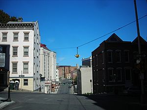
Chapel Street at the eastern end of the hollow, looking north towards the Palace Theater
|
|
| Etymology: General Philip Sheridan, US Civil War | |
| Country | United States |
| State | New York |
| County | Albany County |
| City | Albany |
| Population
(2000)
|
|
| • Total | 791 |
| Time zone | UTC-5 (Eastern Standard Time) |
| • Summer (DST) | UTC-4 (Eastern Daylight Time) |
| Area code | 518 |
| ZIP Code | 12207, 12210 |
Sheridan Hollow is a unique neighborhood in Albany, New York. It sits in a low area, like a small valley or ravine, just north of Downtown Albany. To the south is Capitol Hill, and to the north is Arbor Hill.
Sometimes, people in Albany don't know much about Sheridan Hollow. Even those who work there might not recognize its name. This is because it's often confused with its larger neighbor, Arbor Hill. For example, news stories about events in Sheridan Hollow might mistakenly say they happened in Arbor Hill.
Because the land was not ideal for building homes in early colonial times, Sheridan Hollow grew slowly. Over the centuries, many different groups of people made it their home. These included new immigrants to Albany, like the Irish and Polish, as well as African Americans.
Contents
Exploring Sheridan Hollow's Past
The ravine where Sheridan Hollow is located was formed by a creek called the Vossenkill or Vozenkill. "Kill" is a Dutch word for creek. This creek was named after an early settler, Andries de Vos. Later, in the late 1700s, its name was changed to sound more English, becoming Foxes Creek or Foxenkill.
Early settlements in Beverwyck (which became colonial Albany) mostly avoided this creek and ravine. It wasn't until the late 1700s that people started to develop this area.
Early Development and Street Changes
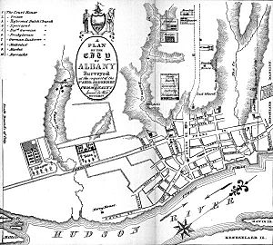
In 1750, the northern edge of Albany's protective wall, called a stockade, ran along the southern side of the Sheridan Hollow ravine. This is where Columbia Street is today. A British Army map from 1758 shows a road going through the ravine. In 1762, the city leaders decided to keep a "Publick Street" in the Foxes Creek area. This street went up to a place called the "Schytt Bergie," which was a hill made of horse dung between what are now Central and Western avenues.
In 1763, the land north of Foxes Creek, up to the city line (which was the northern edge of the Hollow and later Clinton Avenue), was sold. Many of these plots were bought by people who worked as tanners. This area was then known as Woutenbergh, a Dutch word meaning woodland.
In 1764, John Bleeker created a plan for city streets outside the stockade. This plan included Sheridan Hollow, with Clinton Avenue (then called Patroon Street) as the city's northern border. This plan was fully put into action in 1794, after being updated by Simeon De Witt. The old "Publick Street" became Howe Street, but in 1790, many street names were changed to remove British names. Howe Street became Fox Street. Other streets in Sheridan Hollow that changed names in 1790 included Wall Street (became Hare, now Orange), Boscawen Street (to Swan), Hawke Street (to Hawk), Warren Street (to Dove), Johnson Street (to Lark), and Gage Street (to Swallow, now Henry Johnson Boulevard).
During the US Revolutionary War, some people believed that Tories (people loyal to Britain) were buried in Sheridan Hollow.
Burial Grounds and Creek Changes
In 1790, a map by De Witt showed the name Arbor Hill for the first time in Albany. On this map, Arbor Hill was located within Sheridan Hollow, between Orange Street and Clinton Avenue (south and north) and from Chapel Street halfway to Hawk Street (east to west). Later, the name Arbor Hill would be used for the Ten Broeck Mansion and the neighborhood around it, which was once the village of Colonie.
This same map also showed a "Negro burial ground" along the southern edge of the Hollow. However, this burial ground does not appear on any maps made after that, so it might never have been used.
Before 1797, Fox Street was a dirt road on the south side of Fox Creek. In 1797, the creek was made into a channel to flow behind the new houses being built on the north side of Fox Street. Fox Street was then renamed Canal Street. Also in 1797, the land west of Pearl Street was divided and sold. Soon, houses appeared on Canal, Van Schaick (now Monroe), and Orange streets. Starting in 1854, underground sewers were built, and Fox Creek was turned into a large sewer pipe, about 6-foot (1.8 m) wide, under Canal Street.
In 1815, a city directory listed about 40 African American households in Albany, with 11 of them in Sheridan Hollow. Dinah Jackson, who was the first known African American property owner in Albany, owned several pieces of land throughout Sheridan Hollow.
Bridges and Neighborhood Life

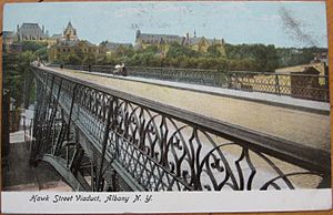
In 1890, a large bridge called a viaduct was built to carry Hawk Street over Sheridan Hollow, connecting Clinton Avenue to Elk Street. In 1896, another viaduct was built for Northern Boulevard, crossing most of Sheridan Hollow from Central Avenue to Sheridan Avenue. The Hawk Street Viaduct was special because it was the first cantilever arch bridge ever built. In 1900, Canal Street was renamed Sheridan Avenue to honor US Civil War General Philip Sheridan, who was born at 83 Canal Street.
Around the early 1900s, health issues like parasite infections were common in Albany. While infection rates dropped in most of the city during the 1800s, they remained high in Sheridan Hollow until the early 1900s. People in Sheridan Hollow continued to use outdoor toilets and wells, which might have been contaminated, even into the 1920s.
During the 19th and early 20th centuries, Sheridan Hollow was a neighborhood mostly made up of immigrants. Families often moved in, then moved out to other neighborhoods as they became more successful. New immigrants would then move in. Between 1917 and 1936, about 91% of the residents changed. The western part of the neighborhood, near West Hill, became home to many Polish immigrants. They built St. Casimir's Church in 1893, which closed in 2003.
The Hawk Street Viaduct was rebuilt in 1925. However, by 1949, it was in bad shape again. Plans to fix it in 1958 didn't happen. In 1968, the bridge was closed to cars and only used by people walking. It was taken down in 1970. The Northern Boulevard Viaduct was replaced in 1980. Today, Northern Boulevard is known as Henry Johnson Boulevard.
Modern Changes and Development
In 1982, a plant in Sheridan Hollow that burned oil to make steam was changed to burn garbage. This was suggested by Mayor Erastus Corning 2nd as part of a system to turn waste into energy. Because Sheridan Hollow is a ravine and the smokestacks were high, much of the pollution from the plant ended up in the nearby Arbor Hill neighborhood. In 1994, Governor Mario Cuomo ordered the garbage-burning part of the plant to close.
Starting in the mid-1990s, the eastern part of Sheridan Hollow began to grow as Downtown Albany was being revitalized. A three-story bar and restaurant called The Big House Brewing Company helped bring more nightlife to downtown. A Hampton Inn and Suites hotel was built nearby in 2005. While The Big House closed, its building is now being turned into apartments and shops. The city plans to build more homes in this part of the Hollow to bring more people closer to downtown. This includes redeveloping the old Boyd Printing Company building on Sheridan Avenue. The plan is to keep the main building for businesses and build a new seven-story apartment building next to the Hampton Inn.
When a new 7-story parking garage was built by New York State along the southern edge of the Hollow, archaeologists studied the area. They wanted to see if the African American burial ground shown on the 1790 De Witt map was there. No signs of the cemetery were found in the 2-acre (0.81 ha) area where the garage was built. However, a memorial to the history of African Americans in Albany was created as part of the parking garage project.
Sheridan Hollow's Location
Sheridan Hollow is, as its name suggests, a low-lying area or ravine. It sits between two higher areas: Capitol Hill to the south and Arbor Hill to the north. Clinton Avenue runs along the northern edge of the Hollow, while Columbia and Elk streets are along the southern edge.
The Hollow gently rises towards the west. It ends more sharply between Henry Johnson Boulevard and Lexington Avenue, where it meets West Hill. Unlike most other ravines and creeks in Albany that were filled in over time, Sheridan Hollow was too deep. This meant that growth in this part of the city remained slow, which also separated Arbor Hill from Downtown.
 |
West Hill | Arbor Hill |  |
|
| Downtown Albany | Pearl Street |
Who Lives in Sheridan Hollow?
According to the 2000 census, 791 people lived in Sheridan Hollow. This area was defined as stretching from North Pearl Street west to Henry Johnson Boulevard, and from Columbia and Spruce streets north to Clinton Avenue.
Here's a look at the population in 2000:
- 35% of residents were under 14 years old.
- 10% were between 15 and 24 years old.
- 33% were between 25 and 44 years old.
- 16% were between 45 and 64 years old.
- 5% were 65 years old or older.
- 54% of the population was female.
For those aged 25 and older:
- 28% did not finish high school.
- 28% had only a high school diploma.
- 38% had some college education or an associate degree.
- 6% had a bachelor's degree.
- 2% had a Master's degree or higher.
In 2000, there were 324 households.
- 40% of these households had children under 18 living with them.
- 20% were married couples living together.
- 30% had a female head of household with no husband present.
- Less than 1% were not families.
- 40% of all households were made up of single individuals.
Regarding household income:
- 36% of households earned less than $10,000.
- 30% earned between $10,000 and $39,999.
- 33% earned between $40,000 and $59,999.
- 1% earned over $60,000.
Getting Around Sheridan Hollow
Because Sheridan Hollow is a ravine, it's not easy to get to from the higher areas to its north and south. From the south side, there are no roads that go straight down into the ravine. However, several stairways allow people to walk down. These stairways connect Elk Street to Sheridan Avenue at Dove Street and at Swan Street.
On the north side, streets like Chapel, North Hawk, Swan, Dove, and Lark streets climb steeply up the ravine to Clinton Avenue. East of Chapel, North Pearl Street is at the open end of the ravine and is fairly flat.
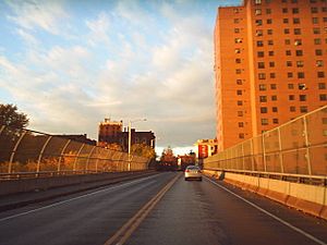
Henry Johnson Boulevard crosses Sheridan Hollow on a viaduct at the western edge of the ravine. Orange Street and Sheridan Avenue are the only two streets that run east-west through the entire length of the Hollow. Lark Street is also part of US Route 9W, and US 9W ends at Clinton Avenue, which is US Route 9.
Famous People from Sheridan Hollow
- Philip Sheridan – A well-known United States Army officer and a general for the Union during the American Civil War.
- Henry Johnson – A hero from World War I and the first American to receive France's highest military award, the Croix de Guerre.
 | Dorothy Vaughan |
 | Charles Henry Turner |
 | Hildrus Poindexter |
 | Henry Cecil McBay |


