Simmons Peak (Tuolumne Meadows) facts for kids
Quick facts for kids Simmons Peak |
|
|---|---|

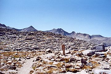
The sign marking the top of Donohue Pass, looking from the John Muir Wilderness/Inyo National Forest side toward the Yosemite side, with a few peaks of the Cathedral Range in the background, including Simmons Peak.
|
|
| Highest point | |
| Elevation | 12,567 ft (3,830 m) NAVD 88 |
| Prominence | 377 ft (115 m) |
| Parent peak | Mount Maclure |
| Geography | |
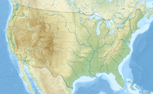
| Location | Madera and Tuolumne counties, California, U.S. |
| Parent range | Ritter Range, Cathedral Range; Sierra Nevada |
| Topo map | USGS Mount Florence, California |
| Climbing | |
| First ascent | Al Steck and George Steck |
| Easiest route | scramble to class 4 |
Simmons Peak is a tall mountain located in the beautiful Yosemite National Park in California, USA. It stands proudly in the Tuolumne Meadows area, which is a popular spot for hikers and nature lovers. This peak is known for its challenging climbs, ranging from simple scrambling to more advanced routes.
Simmons Peak is one of the highest mountains in Yosemite National Park. It ranks as the 12th tallest peak there! Even though it's very high, it's not climbed as often as some other mountains. This might be because it's not on a special list of peaks that many climbers try to conquer, called the Sierra Peaks Section SPS List from the Sierra Club.
Contents
Where is Simmons Peak?
Simmons Peak is found in the Sierra Nevada mountain range. It sits right on the border between two counties in California: Madera County and Tuolumne County. This means it's a landmark for both areas.
Part of the Cathedral Range
The peak is part of a smaller group of mountains called the Cathedral Range. This range is famous for its jagged, granite peaks and stunning views. Simmons Peak is also near the Ritter Range, another impressive mountain area.
Climbing Simmons Peak
Climbing Simmons Peak can be an exciting adventure! The easiest way to get to the top involves a mix of walking and scrambling. Scrambling means you use both your hands and feet to climb over rocks, but it's not as difficult as full rock climbing.
Different Climbing Routes
For more experienced climbers, there are harder routes that go up to a class 4 difficulty. This rating system, called the Yosemite Decimal System, tells climbers how tough a route is. A class 4 climb means you'll need ropes and special gear to stay safe.
Mountains Near Simmons Peak
Simmons Peak is surrounded by many other amazing mountains in Yosemite National Park. Here are some of the peaks you can find nearby:
- Parsons Peak is about 1.3 miles (2.1 km) away.
- Mount Maclure is approximately 1.4 miles (2.3 km) from Simmons Peak.
- Amelia Earhart Peak is located about 1.8 miles (2.9 km) away.
- Mount Florence is also close, at about 1.9 miles (3.1 km) distance.
- Mount Lyell, another famous peak, is around 1.9 miles (3.1 km) from Simmons Peak.
These nearby peaks make the area around Simmons Peak a fantastic place for exploring and enjoying the natural beauty of the Sierra Nevada.
 | Jewel Prestage |
 | Ella Baker |
 | Fannie Lou Hamer |


