
Sims Corner Eskers and Kames facts for kids
Quick facts for kids Sims Corner Eskers and Kames |
|
|---|---|

|
|
| Lua error in Module:Location_map at line 420: attempt to index field 'wikibase' (a nil value). | |
| Location | north central Washington state |
| Designated | 1986 |
Sims Corner Eskers and Kames is a special place in Douglas County, Washington. It's a National Natural Landmark because it shows amazing examples of landforms made by ancient glaciers. These landforms include glacial erratics, terminal moraines, eskers, and kames.
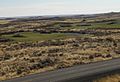
You can find Sims Corner Eskers and Kames in north central Washington state, on a flat area called the Waterville Plateau. Nearby, there are other cool natural landmarks like McNeil Canyon Haystack Rocks and Boulder Park.
Contents
How the Land Was Made
The Plateau's Foundation

Sims Corner Eskers and Kames sits on the Waterville Plateau. This plateau is part of the larger Columbia River Plateau. The ground here is made from many layers of hardened lava.
Millions of years ago, huge amounts of lava flowed across parts of Washington, Oregon, and Idaho. These lava flows were so big they covered a massive area, creating what scientists call a "large igneous province." Most of this lava erupted between 17 and 14 million years ago.
Later, giant floods called the Missoula Floods carved out deep canyons. These floods exposed many layers of the old lava flows. You can see these layers at places like Grand Coulee and Moses Coulee.
The Ice Age's Impact

About two million years ago, the Pleistocene epoch began. This was a time when much of the Earth was covered in ice. Huge glaciers moved into this area. They scraped and shaped the land, reaching far south into the Waterville Plateau.
In some spots, these glaciers were incredibly thick, up to 3 kilometers (about 10,000 feet) deep! Even today, you can see marks on the rock from where the glaciers moved. There are also many large rocks, called glacial erratics, left behind by the ice.
How the Coulees Were Formed

A part of the Cordilleran Glacier, called the Okanogan lobe, moved down the Okanogan River valley. This glacier blocked the path of the ancient Columbia River, causing a huge lake to form, known as Lake Spokane.
At first, the water from Lake Spokane flowed through Foster Coulee and then Moses Coulee to rejoin the Columbia River. But as the glacier grew bigger, it blocked these paths too. The Columbia River then had to find a new way, carving out what we now know as the modern Grand Coulee.
The ice age Columbia River flowed through the Grand Coulee and Dry Falls areas. It then joined Crab Creek, eventually rejoining its current path near the Saddle Mountains.
Images for kids
-
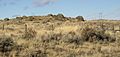
A kame among the glacial drift on the terminal moraine.
-
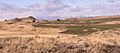
Multiple erratics on the terminal moraine of the Okanogan Lobe. Cascade mountains in the background.
-
Multiple erratics on the terminal moraine of the Okanogan Lobe.
-
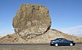
A glacial erratic called Yeager Rock, Waterville Plateau, Washington, USA


