
Singapore River facts for kids
Quick facts for kids Singapore River |
|
|---|---|

Singapore River flowing through Singapore's central business district.
|
|
.jpg)
Early 19th century map of the Singapore River basin.
|
|
| Country | |
| Physical characteristics | |
| Main source | Alexandra Canal |
| River mouth | Marina Channel |
| Length | 3.2 km (2.0 mi) |
|
Singapore River
|
|
|---|---|
|
Planning Area
|
|
| Other transcription(s) | |
| • Chinese | 新加坡河 Xīnjiāpō hé (Pinyin) Sin-ka-pho hô (Hokkien POJ) |
| • Malay | Sungai Singapura (Rumi) سوڠاي سيڠاڤورا (Jawi) |
| • Tamil | சிங்கப்பூர் நதி Ciṅkappūr nati (Transliteration) |

Location in Central Region
|
|
| Country | |
| Region | Central Region
|
| CDC |
|
| Town council |
|
| Constituency |
|
| DGP exhibited |
|
| PA incorporated |
|
| Area | |
| • Total | 0.96 km2 (0.37 sq mi) |
| Area rank | 52nd |
| Population
(2018)
|
|
| • Total | 3,070 |
| • Rank | 32nd |
| • Density | 3,198/km2 (8,280/sq mi) |
| • Density rank | 31st |
| Postal district |
01, 03, 06, 09, 10
|
The Singapore River is a famous river in Singapore. It flows through the southern part of the country and connects to the Marina Reservoir. The area around the river is called the Singapore River Planning Area.
This planning area is part of the Central Area of Singapore. It shares borders with other important areas like River Valley, Museum, Tanglin, Bukit Merah, Outram, and the Downtown Core.
Since 2008, the Singapore River has become a fresh water river. This happened after the Marina Barrage was built.
Contents
Geography of the Singapore River

The Singapore River is about 3.2 kilometers (2 miles) long. It starts at Kim Seng Bridge and flows into Marina Bay. The river actually extends even further, for more than two kilometers, as the Alexandra Canal.
Old maps show that the river originally started from Bukit Larangan, which is now Fort Canning Hill.
History of the Singapore River
The mouth of the Singapore River was once the main Port of Singapore. It was a safe place for ships because it was protected by nearby islands. Because of this, the city of Singapore first grew around the river mouth. It quickly became a busy center for trade, business, and money.
Why the River Became Polluted

Starting in 1819, the Singapore River became very busy. More people moved to the city, and trade grew quickly. But this also caused a big problem: water pollution. Garbage, sewage, and waste from businesses along the river banks were thrown into the water.
Pollution came from many sources. There was waste from pig and duck farms, homes without proper sewage systems, street food sellers, and vegetable markets. River activities like transport, boat building, and repairs also added to the pollution.
By 1977, about 750 small boats called lighters were using the Singapore River. These boats also caused pollution with their waste and oil spills.
Cleaning Up the River
In 1977, Singapore's Prime Minister, Lee Kuan Yew, called for a major clean-up of the Singapore River and the Kallang River. This huge project cost the government about $300 million.
The clean-up involved moving about 4,000 people who lived in illegal settlements along the river. Street hawkers and vegetable sellers, whose waste often ended up in the river, were also moved. The government helped these people find new homes and moved the hawkers to special food centers. Then, they removed all the smelly mud, trash, and debris from the river banks and bottom.
The Singapore River Today
Thanks to these big cleaning efforts, the Singapore River looks very different today. It used to be very busy and polluted, but now it is clean. You can even see monitor lizards and otters returning to the river, which shows how successful the clean-up was!
The Singapore River used to flow directly into the Singapore Strait. But after a lot of land reclamation (creating new land from the sea), the river now flows into Marina Bay.
The main Port of Singapore has moved to a different part of the island. This means the Singapore River is no longer mainly used for trade. Instead, it's now a popular spot for tourists and a beautiful area for the businesses around it. You can even take water taxis to travel along the river.
The river is now part of the Marina Reservoir. A dam called the Marina Barrage was built at the river's end to create a new freshwater reservoir.
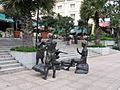
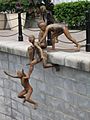
Sculptures Along the River
There are many interesting sculptures along the Singapore River. These artworks often show what life was like for people living and working by the river in Singapore's early days.
Some famous sculptures include:
- First Generation, by Chong Fah Cheong
- Fishing at Singapore River, by Chern Lian Shan
- The River Merchants, by Aw Tee Hong
- A Great Emporium, by Malcolm Koh
- From Chettiars to Financiers, by Chern Lian Shan
- Singapura Cats, by various artists
Bridges and Tunnels Crossing the River


Before 1819, people could only cross the Singapore River by boat. That year, the first wooden jetty and bridge were built. By 2015, 14 bridges had been built across the river. Some bridges were taken down and rebuilt, or their use changed over time.

The very first bridge in Singapore was built over the Singapore River in 1819, where the Elgin Bridge stands today. The first iron Elgin Bridge was built in 1862 and named after Lord Elgin. It was replaced by the current Elgin Bridge in 1926.
Other important bridges include:
- Coleman Bridge (1840/1985)
- Kim Seng Bridge (1862)
- Elgin Bridge (1862/1926)
- Cavenagh Bridge (1870)
- Ord Bridge (1886)
- Read Bridge (1889)
- Pulau Saigon Bridge (1890)
- Anderson Bridge (1910)
- Clemenceau Bridge (1940)
- East West MRT line and North South MRT line between City Hall and Raffles Place (1987/1989)
- Esplanade Bridge (1997)
- Jiak Kim Bridge (1999)
- Robertson Bridge (1998)
- Benjamin Sheares Bridge (1981)
- Alkaff Bridge (1999)
- North East MRT line between Clarke Quay and Dhoby Ghaut (2003)
- Helix Bridge (2010)
- Bayfront Bridge (2010)
- Downtown MRT line and Circle MRT line between Promenade and Bayfront (2012)
- Jubilee Bridge (2015)
- Downtown MRT line between Fort Canning and Chinatown (2017)

.jpg)
Images for kids
-
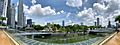
Panoramic view of the Singapore River
-
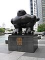
Bird Sculpture by Fernando Botero
-
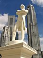
Statue of Stamford Raffles
-
A Great Emporium by Malcolm Koh
-
The First Generation by Chong Fah Cheong
-
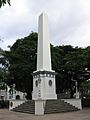
The Dalhousie Obelisk
-
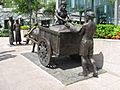
The River Merchants by Aw Tee Hong


_by_Malcolm_Koh,_Asian_Civilisations_Museum,_Singapore_-_20060114.jpg)
_by_Chong_Fah_Cheong,_Cavenagh_Bridge,_Singapore_-_20051203.jpg)

_by_Aw_Tee_Hong,_Cavenagh_Bridge,_Singapore_-_20060530.jpg)
See also
 In Spanish: Río Singapur para niños
