Circle MRT line facts for kids
Quick facts for kids Circle Line |
|
|---|---|

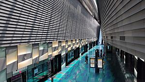
A C830 train at Stadium station
|
|
| Overview | |
| Native name | Malay: Laluan MRT Circle Chinese: 地铁环线 Tamil: இணைப்பு எம்ஆர்டி வழி |
| Status | Operational Under construction (Stage 6) |
| Owner | Land Transport Authority |
| Locale | Singapore |
| Termini | Dhoby Ghaut Stadium Prince Edward Road (From 2026, during busy times) HarbourFront (Until 2026) Marina Bay (Until 2026) |
| Stations | 30 (in use) 3 (being built) |
| Service | |
| Type | Rapid transit Light metro |
| System | Mass Rapid Transit (Singapore) |
| Services | 3 |
| Operator(s) | SMRT Trains Ltd (SMRT Corporation) |
| Depot(s) | Kim Chuan |
| Rolling stock | Alstom Metropolis C830 Alstom Metropolis C830C Alstom Metropolis C851E (future) |
| Daily ridership | 450,000 (2023) |
| History | |
| Planned opening | 1H 2026 (Stage 6) |
| Opened | 28 May 2009 (Stage 3) 17 April 2010 (Stages 1 and 2) 8 October 2011 (Stages 4 and 5) 14 January 2012 (Circle Line extension) |
| Technical | |
| Line length | 35.5 km (22.1 mi) (in use) 4 km (2.5 mi) (being built) |
| Character | Fully underground |
| Track gauge | 1,435 mm (4 ft 8 1⁄2 in) standard gauge |
| Electrification | 750 V DC third rail |
| Operating speed | limit of 78 km/h (48 mph) |
The Circle Line (CCL) is one of Singapore's Mass Rapid Transit (MRT) train lines. It is famous for its orange color on the rail map and for running completely underground.
The line currently runs in a large loop from Dhoby Ghaut station in the city to HarbourFront station in the south. It also has a short branch that goes to Marina Bay. A trip from one end of the line to the other takes about one hour.
One of the coolest things about the Circle Line is that its trains are fully automatic and have no drivers. This makes it one of the longest driverless train lines in the world. The trains, which are made up of three cars each, are a bit smaller than those on other lines, which is why it's called a medium-capacity line.
By 2026, a new section called Stage 6 will open. It will connect HarbourFront to Marina Bay, finally making the Circle Line a complete circle.
Contents
How the Circle Line Was Built
Early Ideas and Planning
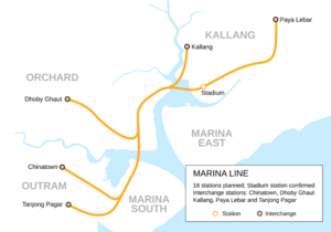
The idea for a circle-shaped train line in Singapore started back in the 1980s. At first, it was called the Marina Line and was planned to serve the Marina Bay area. The original plan was for a line with 18 stations.
Over time, the plans changed. Some parts were removed, and another plan for a light rail line was combined with it. This new, bigger plan became the Circle Line we know today. The government decided that SMRT would be the company to run the new line.
The names for the stations were chosen after asking the public for ideas. This helped make sure the station names were familiar and easy for everyone to use.
Construction and Opening
Building the Circle Line was a huge project that started in 2002. It was built in several stages. The first part to open was Stage 3, a five-station section from Bartley to Marymount, which started running on May 28, 2009.
More sections opened over the next few years. In 2010, the line was extended to Dhoby Ghaut. In 2011, it reached HarbourFront. Finally, a two-station extension to Marina Bay opened in 2012.
The entire project cost nearly S$10 billion. During construction, two stations that were planned to be built later, Caldecott and Haw Par Villa, were built and opened with the rest of the line. However, one station, Bukit Brown, was built as an empty "shell station" and will only be opened in the future when more people live in the area.
Completing the Circle: Stage 6
To make the Circle Line a full circle, a final section called Stage 6 is being built. This 4-kilometer part of the track will connect HarbourFront and Marina Bay. It will add three new stations: Keppel, Cantonment, and Prince Edward Road.
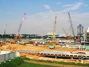
Construction for Stage 6 began in 2017. Building tunnels underground in a busy city is very tricky. For example, the tunnels had to pass just 6.7 meters below the historic Tanjong Pagar Railway Station building. Engineers had to be very careful to protect the old building while they worked.
This final stage is expected to open in the first half of 2026. Once it's done, trains will be able to run in a continuous loop around the city, making travel even more convenient.
Challenges During Construction
Nicoll Highway Collapse
A very serious accident happened on April 20, 2004, during the construction of the Circle Line. A wall holding back the earth for a tunnel near Nicoll Highway station collapsed. This created a huge hole in the ground. Sadly, four workers lost their lives in the accident.
Because of this event, construction on that part of the line was stopped. The station had to be moved about 100 meters away to a new, safer location. This accident also led to much stricter safety rules for all future MRT construction in Singapore. The delay meant the first part of the Circle Line opened in 2009 instead of 2008 as originally planned.
Other Construction Issues
Building a train line underground can cause other problems too. In 2007, a part of a road sank about 20 centimeters near a construction site, and work had to be stopped for safety checks. In another incident in 2008, a hole opened up in a road near Holland Village. Luckily, no one was hurt in these events, and the issues were fixed.
The Circle Line's Route and Stations
The Circle Line is completely underground and connects many important places and other MRT lines.
The line starts at Dhoby Ghaut, where you can change to the North-South and North East lines. From there, it travels east and then north, passing under the Kallang Basin. It connects with the East-West Line at Paya Lebar.
The line then turns west, connecting with other lines at Serangoon and Bishan. It continues southwest, passing through the Botanic Gardens and connecting with the Downtown Line. After passing through areas like Buona Vista and Kent Ridge, it ends at HarbourFront, where it connects again with the North East Line.
List of Stations
All stations on the Circle Line are underground and have platforms that are easy for people using wheelchairs to access.
| Date | Project | Description |
|---|---|---|
| 28 May 2009 | Stage 3 | Bartley – Marymount |
| 17 April 2010 | Stage 1 & 2 | Bartley – Dhoby Ghaut |
| 8 October 2011 | Stage 4 & 5 | Marymount – HarbourFront |
| 14 January 2012 | Circle Line Extension | Promenade – Marina Bay |
| 1H 2026 | Stage 6 | HarbourFront – Marina Bay |
| Future | Future stations between existing stations | Bukit Brown station between Caldecott and Botanic Gardens |
| Station code | Station name | Images | Interchange; Adjacent transportation |
Opening | Cost |
|---|---|---|---|---|---|
CC1 |
Dhoby Ghaut |  |
17 April 2010; 15 years ago |
S$343.94 million |
|
| CC2 |
Bras Basah |  |
— | ||
| CC3 |
Esplanade |  |
|||
| CC4 |
Promenade |  |
― |
||
| CC5 |
Nicoll Highway |  |
— | S$573 million |
|
| CC6 |
Stadium |  |
|||
| CC7 |
Mountbatten |  |
S$322 million |
||
| CC8 |
Dakota |  |
|||
| CC9 |
Paya Lebar |  |
|||
| CC10 |
MacPherson |  |
S$356.1 million |
||
| CC11 |
Tai Seng |  |
— | ||
| CC12 |
Bartley |  |
28 May 2009; 16 years ago |
S$63.5 million | |
| CC13 |
Serangoon |  |
― |
S$155.95 million | |
| CC14 |
Lorong Chuan |  |
— | S$65.0 million | |
| CC15 |
Bishan |  |
― |
S$82.2 million | |
| CC16 |
Marymount |  |
— | S$167.7 million | |
| CC17 |
Caldecott |  |
8 October 2011; 14 years ago |
S$391.59 million |
|
| CC18 Infill station |
Bukit Brown |  |
— | TBA | |
| CC19 |
Botanic Gardens |  |
8 October 2011; 14 years ago |
||
| CC20 |
Farrer Road |  |
— | ||
| CC21 |
Holland Village |  |
S$399.91 million |
||
| CC22 |
Buona Vista |  |
― |
||
| CC23 |
one-north |  |
— | ||
| CC24 |
Kent Ridge |  |
Jurong Region Line (early 2040s) |
||
| CC25 |
Haw Par Villa |  |
— | S$335 million |
|
| CC26 |
Pasir Panjang |  |
|||
| CC27 |
Labrador Park |  |
|||
| CC28 |
Telok Blangah |  |
|||
CC29 |
HarbourFront |  |
― ― |
||
| Stage 6 (under construction, to be ready by 1H 2026) | |||||
| CC30 |
Keppel |  |
— | 1H 2026 | S$313.8 million |
| CC31 |
Cantonment |  |
S$205 million |
||
| CC32 |
Prince Edward Road |  |
S$310.8 million |
||
| Circle Line extension | |||||
| CE1 |
Bayfront |  |
14 January 2012; 14 years ago |
S$463 million |
|
CE2 |
Marina Bay |  |
S$348.4 million |
||
Trains and Technology
The Circle Line Trains
The trains on the Circle Line are electric multiple unit (EMU) trains, which means they are powered by electricity. Each train is made of three connected cars and can carry over 900 passengers.
There have been different models of trains used on the line. The first trains were the C830 model, built in France. Later, more trains of the C830C model were added to handle more passengers. With the opening of Stage 6, even newer trains called the C851E model are being added to the line.
All the trains are kept at the Kim Chuan Depot. When it opened in 2009, it was the largest underground train depot in the world.
Smart Train Control
The Circle Line uses a very smart computer system to run its trains. It is called a Communications-based train control (CBTC) system. This technology allows the driverless trains to talk to a central control center all the time.
This system controls the train's speed, keeps track of where every train is, and makes sure they stay a safe distance apart. It also controls the automatic platform screen doors at the stations, which only open when a train has safely stopped. This high-tech system is what makes the Circle Line so safe and efficient.
 | Tommie Smith |
 | Simone Manuel |
 | Shani Davis |
 | Simone Biles |
 | Alice Coachman |


