
Sinister Peak facts for kids
Quick facts for kids Sinister Peak |
|
|---|---|

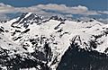
Sinister Peak from Maple Pass area
|
|
| Highest point | |
| Elevation | 8,440+ ft (2,570+ m) |
| Prominence | 840 ft (260 m) |
| Geography | |

Sinister Peak
Location in Washington (state)

Sinister Peak
Location in the United States
|
|
| Location | Chelan and Skagit County, Washington, U.S. |
| Parent range | Cascade Range |
| Topo map | USGS Dome Peak |
| Climbing | |
| First ascent | Lloyd Anderson, Jim Crooks, Clint Kelley, May 29, 1939 |
| Easiest route | class 3 |
Sinister Peak is a tall mountain in the Cascade Range of Washington, USA. It stands at 8,440+ ft (2,570+ m) high. This peak is found within the Mount Baker-Snoqualmie and Wenatchee National Forests. It is also part of the wild Glacier Peak Wilderness and the North Cascades area.
Sinister Peak is located close to Dome Peak, about one mile to its east. Both peaks are connected by a high ridge. You can find the Chickamin Glacier on the north side of Sinister Peak. The Garden Glacier is just to the southeast. While some paths to the top are challenging, you can reach the summit with a moderate climb.
Contents
Weather Around Sinister Peak
Sinister Peak is in a "marine west coast" climate zone. This means it gets a lot of moisture from the Pacific Ocean. Most weather systems start over the Pacific. They then travel northeast towards the Cascade Mountains.
How Mountains Affect Weather
When these weather systems reach the North Cascades, the tall mountains force the air upwards. As the air rises, it cools down. This causes the moisture in the air to turn into rain or snow. This process is called orographic lift. Because of this, the western side of the North Cascades gets a lot of rain and snow. This is especially true during the winter months.
During winter, the weather is often cloudy. However, in summer, high-pressure systems form over the Pacific Ocean. These systems bring clear skies. This means there is often little to no cloud cover during the summer months.
How Sinister Peak Formed
The North Cascades area has very rugged land. It features sharp peaks, rocky ridges, and deep valleys carved by glaciers. There are also tall, pointed rocks made of granite. These amazing landscapes were created by geological events over millions of years. These events also caused big changes in height across the Cascade Range. This led to different climates in various areas.
Ancient Geological Events
The Cascade Mountains began to form millions of years ago. This was during the late Eocene Epoch. At that time, the North American Plate was slowly moving over the Pacific Plate. This movement caused many periods of volcanic activity. Also, small pieces of the Earth's crust, called terranes, came together. These pieces helped create the North Cascades about 50 million years ago.
Impact of Glaciers
During the Pleistocene period, which was over two million years ago, glaciers moved across the land many times. As they advanced and retreated, they scraped and shaped the landscape. They left behind piles of rock and debris. The river valleys in the area have a U-shape. This shape is a direct result of these recent glaciers.
The main forces that created the tall peaks and deep valleys of the North Cascades are uplift (when land rises) and faulting (when cracks form in the Earth's crust). These processes, combined with the action of glaciers, shaped the area we see today.
Images for kids
-
Dome Peak (left), Sinister Peak (center), Gunsight Peak (right) seen from SSE at Cloudy Pass

