
Sinking Ship (Grand Canyon) facts for kids
Quick facts for kids Sinking Ship |
|
|---|---|

Sinking Ship, aka Three Castles
|
|
| Highest point | |
| Elevation | 7,344 ft (2,238 m) |
| Prominence | 304 ft (93 m) |
| Isolation | 2.30 mi (3.70 km) |
| Parent peak | Grandview Benchmark (7,530 ft) |
| Geography | |

Sinking Ship
Location in Arizona

Sinking Ship
Location in the United States
|
|
| Location | Grand Canyon National Park Coconino County, Arizona, US |
| Parent range | Coconino Plateau Colorado Plateau |
| Topo map | USGS Grandview Point |
| Type of rock | limestone, sandstone, mudstone |
| Climbing | |
| Easiest route | class 4 scrambling |
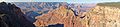
Sinking Ship is a cool rock formation in the Grand Canyon. It's a peak that stands 7,344-foot (2,238 m) tall. You can find it in Coconino County, in northern Arizona, USA.
This unique butte is about 1.7 miles (2.7 km) southeast of Grandview Point. That's a popular spot on the Grand Canyon's South Rim. It's also 1.25 miles (2.01 km) southwest of another cool spot called Coronado Butte. Sinking Ship rises a huge 4,800 feet (1,500 m) above the Colorado River in just 4 miles (6.4 km)! The area has a cold semi-arid climate, which means it's usually dry and can get quite cold.
Why Is It Called Sinking Ship?
This amazing rock was first called "Three Castles." But in 1932, the U.S. Board on Geographic Names officially changed its name. They decided to call it "Sinking Ship."
The name "Sinking Ship" comes from how the rock layers look. They are tilted, as if a ship is sinking into the canyon. This tilt was caused by the rock bending over time. M. R. Tillotson, who was the superintendent of Grand Canyon National Park from 1922 to 1938, gave it this descriptive name.
Exploring the Geology of Sinking Ship
The very top of Sinking Ship is made of a hard rock called Kaibab Limestone. This limestone sits on top of a cream-colored rock called Coconino Sandstone. The sandstone forms tall cliffs. It's one of the younger rock layers in the Grand Canyon. This sandstone was formed about 265 million years ago from ancient sand dunes.
Below the Coconino Sandstone, you'll find the Hermit Formation. This layer is made of softer rock that forms slopes. Underneath that is the Supai Group. Even further down, you can see layers of Redwall Limestone and the Tonto Group.
Most of the rock layers in the Grand Canyon are flat. But at Sinking Ship, they are tilted! This tilt happened because of something called the Cremation Fault and a monocline. A fault is like a crack in the Earth's crust. A monocline is a bend in the rock layers. This old fault was active again during a time called the Laramide orogeny. The tilt of Sinking Ship towards the east is because it sits right on this bend, or monocline. Water from Sinking Ship flows north into the Colorado River through Hance Creek.
Images for kids
-
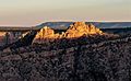
Sunset illuminating Sinking Ship
-
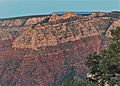
West aspect from Grandview Point
-
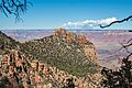
From the southeast.
-
Sinking Ship, looking like "Three Castles"
-
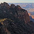
Coronado Butte centered, with Sinking Ship to left and shaded.


