
Coronado Butte facts for kids
Quick facts for kids Coronado Butte |
|
|---|---|
 |
|
| Highest point | |
| Elevation | 7,162 ft (2,183 m) |
| Prominence | 1,122 ft (342 m) |
| Isolation | 1.25 mi (2.01 km) |
| Parent peak | Sinking Ship (7,344 ft) |
| Geography | |

Coronado Butte
Location in Arizona

Coronado Butte
Location in the United States
|
|
| Location | Grand Canyon National Park Coconino County, Arizona, US |
| Parent range | Coconino Plateau Colorado Plateau |
| Topo map | USGS Cape Royal |
| Type of rock | sandstone, siltstone, mudstone |
| Climbing | |
| First ascent | 1890s |
| Easiest route | class 3+ scrambling |
Coronado Butte is a tall mountain peak, about 7,162 feet (2,183 meters) high. It's located in the amazing Grand Canyon in Arizona, United States. You can find it about one mile west of Moran Point, a popular viewpoint on the South Rim of the canyon. Its closest taller neighbor is a peak called Sinking Ship.
This butte stands out because it rises a huge 4,600 feet (1,400 meters) above the Colorado River in just 2.5 miles! Coronado Butte is named after Francisco Vázquez de Coronado, an explorer. His 1540 expedition was the first time Europeans saw the Grand Canyon. The name "Coronado Butte" became official in 1906. The first people to climb it were John Hance and a tourist in the 1890s. The area around Coronado Butte has a cold semi-arid climate. This means it's usually dry and can get quite cold.
What is Coronado Butte Made Of?
The very top of Coronado Butte is made of a cream-colored rock called Coconino Sandstone. This sandstone forms cliffs and has a Kaibab Limestone layer on top. The Coconino Sandstone is about 265 million years old. It was formed from ancient sand dunes.
Below the Coconino Sandstone, you'll find other layers of rock. These include the Hermit Formation, the Supai Group, and the Redwall Limestone. Even further down are layers from the Tonto Group. When it rains on Coronado Butte, the water flows north towards the nearby Colorado River.
Gallery
-
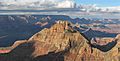
South side of the butte
-
Coronado Butte in the middle, with Sinking Ship to the left
-
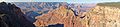
Seen from near the Buggeln picnic area
-
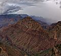
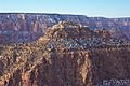
Coronado Butte from Moran Point
-
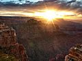
Sunset colors on Coronado Butte


Images for kids
-
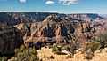
East side, viewed from Moran Point

