Slip End facts for kids
Quick facts for kids Slip End |
|
|---|---|
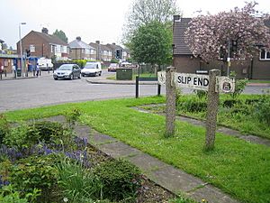
 Slip End village centre |
|
| Population | 1,842 |
| OS grid reference | TL080185 |
| Civil parish |
|
| Unitary authority | |
| Ceremonial county | |
| Region | |
| Country | England |
| Sovereign state | United Kingdom |
| Post town | LUTON |
| Postcode district | LU1 |
| Dialling code | 01582 |
| Police | Bedfordshire |
| Fire | Bedfordshire and Luton |
| Ambulance | East of England |
| EU Parliament | East of England |
| UK Parliament |
|
Slip End is a small village and a local government area called a civil parish in Central Bedfordshire, England. It's located very close to the larger town of Luton. The parish of Slip End includes not only the main village but also smaller communities called hamlets. These hamlets are Lower Woodside, Woodside, and Pepperstock. In 2021, about 1,842 people lived in Slip End.
The name "Slip End" might be connected to brickworks. "Slip" is an old English word for clay. "End" is a common part of place names in Bedfordshire. It often refers to small settlements built outside larger villages.
So, Slip End might have been named in the early 1800s. This was when a few houses were built near new brickworks. This area was not developed before, unlike the older settlements of Woodside and Pepperstock nearby. Another idea is that "the slip" refers to a deep layer of clay. This clay sits between layers of chalk, which is the main rock in Central Bedfordshire. The southern edge of this clay layer ends right at Slip End.
Contents
History of Slip End
Discover the past of this interesting village.
The Village School
The school in Slip End was once located on Front Street and Summer Street. This site is now home to a small group of flats and houses called Old School Walk. It was a "board school," meaning it was set up after the Education Act 1870. This law made sure that all children could get an education.
The school taught all ages, from younger children to older students. In 1947, it started teaching students up to 15 years old. One hundred years after it first opened, the school moved to its current location on Rossway. This new site used to be clay pits, where clay was dug out for local brick making. Today, the school is a primary school. It teaches children from about 3 and a half years old up to 11 years old.
Parish Creation
The parish of Slip End was created in 2001. Before that, it was part of a larger parish called Caddington and Slip End. This change gave Slip End its own local government.
The M1 Motorway
The M1 motorway runs right next to the village. This important road was officially opened from Slip End. This event is remembered by a large concrete slab on the bridge near the village. The slab has an inscription that celebrates the opening:
-
-
-
LONDON-YORKSHIRE MOTORWAY
THIS SLAB WAS SEALED BY THE
Rt Hon HAROLD WATKINSON M.P.
MINISTER OF TRANSPORT
INAUGURATION DAY
24th MARCH 1958
-
-
This slab marks a significant moment in the village's history. It shows Slip End's connection to a major national transport route.
Local Places and Activities
Find out about the useful and fun places in Slip End.
Village Hall
The village hall was built around 1901. It has space to park about 40 cars. The hall can hold up to 100 people for dancing events. It can also host meetings for up to 200 people. It's a great place for community events.
Peter Edwards Hall and Playing Fields
The Peter Edwards Hall and Playing Fields are located at the Luton end of the village. They are right next to the church. Here, you can find tennis courts for playing tennis. There is also a football pitch, perfect for a game of soccer.
Local Pubs
Slip End has two pubs where people can meet and relax. "The Rising Sun" is located on Front Street. The "Frog and Rhubarb" can be found on Church Road.
See also
 In Spanish: Slip End para niños
 | William L. Dawson |
 | W. E. B. Du Bois |
 | Harry Belafonte |


