Smith Valley, Nevada facts for kids
Quick facts for kids
Smith Valley, Nevada
|
|
|---|---|

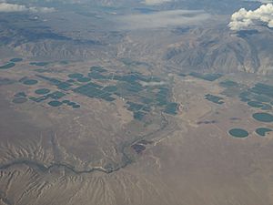
Aerial view of Smith Valley
|
|

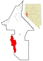
Location of Smith Valley, Nevada
|
|
| Country | United States |
| State | Nevada |
| County | Lyon |
| Area | |
| • Total | 103.88 sq mi (269.06 km2) |
| • Land | 101.96 sq mi (264.07 km2) |
| • Water | 1.92 sq mi (4.98 km2) |
| Elevation | 4,731 ft (1,442 m) |
| Population
(2020)
|
|
| • Total | 1,710 |
| • Density | 16.77/sq mi (6.48/km2) |
| Time zone | UTC-8 (Pacific (PST)) |
| • Summer (DST) | UTC-7 (PDT) |
| FIPS code | 32-68050 |
| GNIS feature ID | 2408748 |
Smith Valley is a special kind of community in Lyon County, Nevada, USA. It's called a "census-designated place" or CDP. This means it's a place where people live that isn't officially a city or town, but the government still counts its population. In 2010, about 1,603 people lived here. By 2020, the population grew to 1,710!
Contents
Discover Smith Valley's Location
Smith Valley is found in the southwestern part of Lyon County. It sits in a valley that shares its name. This valley is surrounded by several mountain ranges. To the west are the Pine Nut Mountains. The Buckskin Range is to the north, and the Singatse Range is to the east. To the southwest are the Wellington Hills, and the Pine Grove Hills are to the southeast.
Getting Around Smith Valley
You can drive through Smith Valley using Nevada State Route 208. This road goes northeast about 23 miles (37 km) to Yerington, which is the main town for Lyon County. If you go west about 15 miles (24 km), you'll reach U.S. Route 395 near Topaz Lake. Another road, Nevada State Route 338, goes south from Smith Valley for about 30 miles (48 km) to the California border. From there, California State Route 182 continues another 14 miles (23 km) to Bridgeport, California.
Land and Water in Smith Valley
The Smith Valley area covers about 269.06 square kilometres (103.88 sq mi). Most of this is land, but about 4.98 square kilometres (1.92 sq mi) is water. The West Walker River flows through the middle of the valley. It then leaves the valley through a place called Wilson Canyon. The northern part of the valley is a "closed basin." This means that any water that flows into it stays there and doesn't flow out to the ocean. Artesia Lake is in the lowest part of this area.
How Smith Valley Got Its Name
Smith Valley is named after an American fur trapper and explorer named Jedediah Smith. He traveled through this area in the spring of 1827. He was on his way to a fur trade meeting after crossing the Sierra Nevada mountains.
People of Smith Valley
| Historical population | |||
|---|---|---|---|
| Census | Pop. | %± | |
| 2020 | 1,710 | — | |
| U.S. Decennial Census | |||
In 2000, there were 1,422 people living in Smith Valley. They lived in 553 homes, and 419 of these were families. The population density was about 11.8 people for every square mile.
Many different groups of people make up Smith Valley. In 2000, about 89% of the people were White. There were also smaller numbers of African American, Native American, and Asian people. About 19% of the population was Hispanic or Latino.
Many homes in Smith Valley had children under 17 living there. Most homes were married couples living together. The average home had about 2.56 people.
The people in Smith Valley are of all ages. In 2000, about 24% were under 18 years old. About 15.6% were 65 years or older. The average age was 43 years old.
Famous People from Smith Valley
Wovoka, also known as Jack Wilson, was a very important Northern Paiute religious leader. He started the Ghost Dance movement in 1890. Wovoka was born and grew up right here in Smith Valley!
Water in Smith Valley
The West Walker River flows through Smith Valley. For over 100 years, people have used water from this river to water their farms and ranches. Taking so much water from the river has caused problems for Walker Lake. This lake is at the end of the river's path. Taking too much water has hurt the lake's natural environment. The main crops grown in Smith Valley are alfalfa and hay.
Water Challenges
People in Smith Valley also use water from underground, called groundwater. They have been using this water faster than it can be refilled for at least 50 years. In 2015, the Nevada Department of Water Resources tried to limit how much groundwater could be used. However, a court later said this rule was not fair to some water users.
A study in 2022 showed that the groundwater level in Smith Valley has dropped by more than 100 feet (30 m) in the last 50 years. This means a lot of underground water has been used. The study also found that the Walker River itself is losing more water into the ground each year. This suggests that pumping groundwater is making the river lose water faster.
Smith Valley High School Alumni
- Robin L. Titus is a Republican member of the Nevada Assembly. She is a notable person who went to Smith Valley High School.
See also
 In Spanish: Smith Valley (Nevada) para niños
 | Mary Eliza Mahoney |
 | Susie King Taylor |
 | Ida Gray |
 | Eliza Ann Grier |

