
Spark Plug Mountain facts for kids
Quick facts for kids Spark Plug Mountain |
|
|---|---|

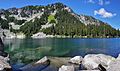
East aspect, above Glacier Lake
|
|
| Highest point | |
| Elevation | 6,320 ft (1,930 m) |
| Prominence | 440 ft (130 m) |
| Isolation | 1.0 mi (1.6 km) |
| Parent peak | Surprise Mountain (6,330 ft) |
| Geography | |

Spark Plug Mountain
Location in Washington (state)

Spark Plug Mountain
Location in the United States
|
|
| Location | King County Washington state, U.S. |
| Parent range | North Wenatchee Mountains Cascade Range |
| Topo map | USGS Scenic |
| Climbing | |
| Easiest route | scrambling |
Spark Plug Mountain is a mountain in Washington state, USA. It stands about 6,320 feet (1,926 meters) tall. This mountain is located in King County, near Glacier Lake.
It is part of the Wenatchee Mountains, which are a smaller part of the larger Cascade Range. Spark Plug Mountain is inside the Alpine Lakes Wilderness area. This land is looked after by the Mount Baker-Snoqualmie National Forest.
Nearby mountains include Surprise Mountain, which is a bit taller and about 1 mile (1.6 km) away. Thunder Mountain is also close by, across Glacier Lake. The famous Pacific Crest Trail goes right past Glacier Lake, between Spark Plug Mountain and Thunder Mountain.
Below the north side of Spark Plug Mountain is a smaller lake called Spark Plug Lake. Another peak, Little Spark Plug, is also nearby. Water from Spark Plug Mountain flows into Surprise Creek and Deception Creek. These creeks then join the Skykomish River.
Weather Around Spark Plug Mountain
Spark Plug Mountain is in a place with a marine west coast climate. This means it gets a lot of rain and snow. Most of the weather comes from the Pacific Ocean.
These weather systems move northeast towards the Cascade Mountains. When they hit the mountains, the air is forced to rise. As the air goes up, it cools down and drops its moisture. This causes a lot of rain or snow to fall on the west side of the Cascades.
Winters here are usually cloudy and snowy. But in summer, high-pressure systems over the Pacific Ocean often bring clear skies. The snow in this area can be wet and heavy. This can sometimes create a danger of avalanches. The best time to visit or climb Spark Plug Mountain is usually from July to September.
How Spark Plug Mountain Was Formed
The Alpine Lakes Wilderness area has very rugged land. It features sharp peaks, rocky ridges, and deep valleys carved by glaciers. There are also many granite rock walls and over 700 mountain lakes.
The varied landscape and big changes in elevation in the Cascade Range were created by geological events over millions of years. These events also led to the different climates you see today.
The Cascade Mountains started forming millions of years ago, during the late Eocene Epoch. This happened when the North American Plate slowly moved over the Pacific Plate. This movement caused many volcanic eruptions and rock formations. Also, small pieces of the Earth's crust, called terranes, helped form the North Cascades about 50 million years ago.
About two million years ago, during the Pleistocene period, glaciers played a big role. Huge sheets of ice moved back and forth many times. They scraped and shaped the land, creating the "U"-shaped valleys we see today. The last glaciers in the Alpine Lakes area started melting about 14,000 years ago.
The combination of the land pushing upwards (called uplift) and cracks in the Earth's crust (called faulting), along with the glaciers, created the tall peaks and deep valleys of the Alpine Lakes Wilderness.
More Pictures
-
Spark Plug Mountain
-

Surprise Mountain (left), Spark Plug Mountain (right)

