Split Mountain (California) facts for kids
Quick facts for kids Split Mountain |
|
|---|---|

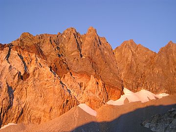
Sunrise on Split Mountain's east face, September 2004.
|
|
| Highest point | |
| Elevation | 14,064 ft (4,287 m) NAVD 88 |
| Prominence | 1,525 ft (465 m) |
| Parent peak | North Palisade |
| Listing |
|
| Geography | |
| Location | Fresno / Inyo counties, California, United States |
| Parent range | Sierra Nevada |
| Topo map | USGS Split Mountain |
| Geology | |
| Mountain type | granite |
| Climbing | |
| First ascent | 1887, Frank Saulque and party |
| Easiest route | North slope, scramble (class 2) |
Split Mountain is a very tall mountain in the Sierra Nevada mountain range in California, United States. It's known as a "fourteener" because it stands over 14,000 feet tall. At 14,064 feet (4,287 meters), it's the eighth-highest peak in California. This impressive mountain is located near the southeast part of the famous Palisades group of peaks.
Split Mountain's Location and Rocks
Split Mountain has two peaks that line up north-south along the top of the Sierra Nevada mountain range. This line of peaks also divides two areas: Fresno County and Kings Canyon National Park on the west side, and Inyo County and the Inyo National Forest on the east side. Water from the mountain's western slopes flows into the Kings River, while water from the eastern slopes goes into the Owens River.
The eastern side of the mountain looks like it has two different colors. This cool effect happens because it's made of two types of rock. Darker granodiorite rock sits on top of a lighter colored rock called leucogranite.
How Split Mountain Got Its Name
The name "Split Mountain" was first used in 1895 by a mountaineer named Bolton Brown. He chose this name because the mountain has a double summit, meaning it looks like it's split into two peaks at the top. Sometimes, people also called it Southeast Palisade or South Palisade.
Climbing Split Mountain
Climbing Split Mountain is considered one of the easier challenges among California's "fourteeners." The simplest way to reach the top is by taking the north slope. This route is a scramble, which means it involves using your hands for balance but doesn't usually require ropes or special climbing gear.
You can approach the north slope from either the west or the east.
- In 1902, climbers Joseph LeConte, Helen LeConte, and Curtis Lindley took the easier western path from a place called Upper Basin.
- A more common way to reach the north face is from the east, starting at the Red Lake trailhead. This trail is about 6 miles (10 kilometers) long and climbs 4,000 feet (1,219 meters) up to Red Lake. From the lake, you'll climb another 3,500 feet (1,067 meters) across the land, including a short section where you might need to use your hands to get over a ridge, to reach the summit.
For experienced climbers, there are many more difficult and technical routes up both the north and south peaks of Split Mountain.
 | Emma Amos |
 | Edward Mitchell Bannister |
 | Larry D. Alexander |
 | Ernie Barnes |


