
Spreitenbach facts for kids
Quick facts for kids
Spreitenbach
|
||
|---|---|---|
 |
||
|
||

Spreitenbach
Location in Switzerland

Spreitenbach
Location in Canton of Aargau
|
||
| Country | Switzerland | |
| Canton | Aargau | |
| District | Baden | |
| Area | ||
| • Total | 8.6 km2 (3.3 sq mi) | |
| Elevation | 421 m (1,381 ft) | |
| Population
(Dec 2020 )
|
||
| • Total | 12,126 | |
| • Density | 1,410/km2 (3,652/sq mi) | |
| Postal code |
8957
|
|
| Surrounded by | Würenlos, Oetwil an der Limmat, Dietikon, Bergdietikon, Bellikon, Remetschwil, and Killwangen | |
| Twin towns | Bra (Italy) | |


Spreitenbach (pronounced Spräitebach in local German) is a town in Switzerland. It's located in the Limmat Valley, a beautiful area in the canton of Aargau. This town is southeast of the district center of Baden. It sits right on the border with the canton of Zurich. Even though it's growing, Spreitenbach is one of Switzerland's smaller towns. To be called a city in Switzerland, a place usually needs over 10,000 people.
Contents
Exploring Spreitenbach's Geography

Spreitenbach is located between the cities of Baden and Zurich. It lies on the south side of the Limmat River, within the Limmat Valley. The town is built on a flat area between the Heitersberg hills and the river.
The older part of Spreitenbach is in the south. The Spreitenbach stream flows through this area, which still looks very traditional. North of the old town, you'll find the modern part. This area has many apartment buildings, industrial zones, and large shopping centers. Further north, across the motorway and railway, is the Neuhard industrial zone. This area is right by a bend in the Limmat River. The eastern part of the plain is home to the large Zurich-Limmattal railway yard.
Nature and Green Spaces
In the forested area south of Spreitenbach, near the border with Dietikon, is the Franzosenweiher (meaning "French Pond"). This pond got its name because Napoleon's soldiers reportedly camped here. They were on their way to cross the Limmat River at Kloster Fahr.
Another special place is the "Altes Bad" biotope. This is a protected natural area with a pond and wetlands. It's home to many different kinds of plants. The town has made sure this area and the nearby forest are kept safe for nature.
About 2 kilometers (1.2 miles) west of town, you'll find a small village called Heitersberg. It sits high up on a plateau at 650 meters (2,130 feet). The highest point in Spreitenbach is not far from here, at 672 meters (2,205 feet). The lowest point in the town is the Limmat River, at 385 meters (1,263 feet).
As of 2006, Spreitenbach covers an area of 8.6 square kilometers (3.3 square miles). About 27.8% of this land is used for farming. Forests cover 35.3% of the area. Buildings and roads make up 35.5% of the land. The remaining 1.4% is made up of rivers or lakes.
Spreitenbach's Rich History
Spreitenbach was first mentioned in history way back in the year 1124. At that time, many convents owned land here. The Knights of Schönenwerd, from Dietikon, were also important landowners. However, they had to sell all their farms to the Wettingen Abbey between 1274 and 1287.
In 1415, the Old Swiss Confederacy took control of the Aargau region. Spreitenbach became part of the Dietikon district within the County of Baden. This county was a part of the confederacy. In 1541, the Wettingen Abbey gained the right to hold local trials. Sadly, many houses in the town were destroyed by fires in 1670 and again in 1785.
In March 1798, France invaded Switzerland and created the Helvetic Republic. Spreitenbach became a municipality in the short-lived canton of Baden. Since 1803, it has been part of the canton of Aargau.
Growth and Modernization
On August 9, 1847, a railway line opened between Zurich and Baden. The people of Spreitenbach asked for the railway to be built far from their town. Because of this, the closest train station today is in Killwangen, a much smaller municipality.
Industrialization began in Spreitenbach in 1862. This was when a cotton spinning factory opened.
In the 1950s, Spreitenbach was still a quiet farming town. It had a few small businesses and even a place for gliders (planes without engines). But then, a huge building boom started. At that time, the canton of Zurich had strict rules about unmarried couples living together (these rules changed in 1972). This meant many people looked for homes in nearby areas like Spreitenbach in the canton of Aargau. This, along with the general growth of the Zurich area, led to a high demand for housing.
A "New Spreitenbach" was planned and built. The idea was to create a "satellite city" with many tall apartment buildings and special areas for businesses and factories. In the mid-1960s, planners thought the town would grow to 35,000 people and have 20,000 jobs. However, the 1973 oil crisis and economic problems in the 1970s changed these plans. The vision became more modest. In 1981, a new building plan was made. It focused on less dense housing and moved away from building so many high-rises.
In 1970, Switzerland's first American-style shopping mall opened in Spreitenbach. A second, even larger mall followed in 1974. Spreitenbach became an example of how towns on the Swiss Plateau were spreading out. Between 1960 and today, the population of Spreitenbach has grown more than five times! No other town in the canton of Aargau has seen such fast growth recently.
Spreitenbach's Coat of Arms
The official description of Spreitenbach's coat of arms is: "Quarterly, Azure, a crowned leopard head Or; Gules, a six-pointed star Argent." This means it's divided into four sections. Two sections are blue with a crowned golden leopard head. The other two sections are red with a white six-pointed star.
An older coat of arms from 1872 showed a linden tree and a fir tree. The current coat of arms was suggested by local historians and adopted in 1930. It can be seen on a map of the canton of Zurich from 1667. The leopard head represents the Schönenwerd nobility, who were important landowners. The star represents the Wettingen Abbey, which used to be the local judges.
People and Population (Demographics)

Spreitenbach has a population of 12,126 people as of 31 December 2020. In 2008, about 50.5% of the people living in Spreitenbach were foreign nationals. Over the last 10 years, the population has grown by 18.5%.
Most people in Spreitenbach speak German (72.1%). Italian is the second most common language (7.0%), followed by Serbo-Croatian (6.1%). Other languages spoken include Albanian, Turkish, Spanish, French, and Portuguese.
In 2000, about 40.0% of the people were Roman Catholic. 20.4% were Reformed (Protestant). Other religions included Orthodox (7.9%) and Muslim (14.7%).
The age of people in Spreitenbach in 2008 was:
- 11.0% were children aged 0-9 years old.
- 11.4% were teenagers aged 10-19.
- 16.7% were young adults aged 20-29.
- 15.4% were adults aged 30-39.
- 15.9% were adults aged 40-49.
- 13.6% were adults aged 50-59.
- 9.1% were seniors aged 60-69.
- 4.8% were seniors aged 70-79.
- 1.7% were seniors aged 80-89.
- 0.4% were seniors aged 90 and older.
In 2000, there were 715 homes with 1 or 2 people. There were 2,506 homes with 3 or 4 people. And 560 homes had 5 or more people. On average, there were 2.36 people per household. In 2008, there were 480 single-family homes, which was about 10.7% of all homes. The town had a very low vacancy rate of 0.9% for apartments. In 2007, about 1.9 new homes were built for every 1000 residents.
Spreitenbach's Economy


Spreitenbach is an important economic area. It's located in a key spot west of the Zurich metropolitan area. More than 700 businesses operate here, employing about 6,900 workers.
- Only 1% of jobs are in farming.
- 22% are in manufacturing and industry.
- A large 77% are in the service sector.
The town is well-known for its two big shopping centers, Shoppi and Tivoli. Also, the IKEA furniture store here was the first one opened outside of Scandinavia, back in 1973. These stores are a big part of the service economy.
Several leading companies have operations in Spreitenbach. Some notable ones include:
- Zweifel Pomy-Chips (known for potato chips)
- Bridgestone (car tires)
- Johnson & Johnson (pharmacy and cosmetics)
- Nestlé (food products)
- Miele (household goods)
- Globus (retail trade)
As of 2000, 5,192 people who lived in Spreitenbach also worked. However, about 71.4% of these residents worked outside of Spreitenbach. At the same time, 4,327 people traveled into Spreitenbach for work. There were a total of 5,810 jobs in the municipality (for at least 6 hours per week).
Transportation in Spreitenbach
Spreitenbach is located close to the A3 motorway, and a new on-ramp is planned. The town is also on the busy highway connecting Zurich and Baden. The entrance to the A1 autobahn at Dietikon is just 2 kilometers (1.2 miles) east of Spreitenbach. Until 2008, Spreitenbach only had an entrance for traffic going to and from Bern.
In Spreitenbach and its neighbor Dietikon, a very large railway classification yard was built in 1978. This yard, called Rangierbahnhof-Limmattal (RBL), was later expanded. It's used to sort train cars.
Spreitenbach is served by several bus lines. Lines 2, 4, and 8 of the Regionale Verkehrsbetriebe Baden-Wettingen connect to Killwangen, Neuenhof, Wettingen, and Baden. A line from the ZVV (Zurich Transport Network) goes to Zurich, passing through Dietikon, Urdorf, and Sclieren.
The closest train stations for the S-Bahn Zürich are Killwangen-Spreitenbach railway station and Dietikon railway station. These stations are served by lines S3 and S12. In the future, a new tram line called the Stadtbahn Limmattal is planned to have stops in Spreitenbach.
Education in Spreitenbach
All levels of required primary schooling are taught in Spreitenbach. For higher education, the closest "Kantonsschule" (a type of high school called a Gymnasium) is in Wettingen or Baden.
As of 2000, about 57.2% of the people in Spreitenbach (aged 25-64) had completed either high school or further higher education, like university or a technical college (Fachhochschule).
In the 2008/2009 school year:
- 724 students attended primary school in Spreitenbach.
- 369 students attended secondary school.
- 186 students were studying at the university or tertiary level in the municipality.
Important Historical Site
The Moosweg, which is a neolithic grave site, is listed as a Swiss heritage site of national significance. This means it's a very important historical place for the country.
Notable People from Spreitenbach
- Bruno Weber (1931–2011) was a Swiss artist and architect. He specialized in fantastic realism and built the amazing Bruno Weber Park, a sculpture park located in Spreitenbach and Dietikon.
- Thomas Junghans (born 1977) is a Swiss-German darts player who lives in Spreitenbach.
- Diego Benaglio (born 1983) grew up in Spreitenbach. He is a Swiss football goalkeeper who played almost 400 club games, mostly for VfL Wolfsburg. He also played 61 games for the Switzerland national football team.
Images for kids
-
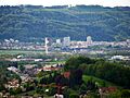
View from the east as seen from the Käferberg-Waidberg (already used in infobox)
See also
 In Spanish: Spreitenbach para niños
