
Springsure facts for kids
Quick facts for kids SpringsureQueensland |
|||||||||||||||
|---|---|---|---|---|---|---|---|---|---|---|---|---|---|---|---|

Entrance sign, Springsure, Queensland
|
|||||||||||||||

Springsure
Location in Queensland
|
|||||||||||||||
| Population | 950 (2021 census) | ||||||||||||||
| • Density | 6.71/km2 (17.4/sq mi) | ||||||||||||||
| Postcode(s) | 4722 | ||||||||||||||
| Elevation | 344.9 m (1,132 ft) | ||||||||||||||
| Area | 141.6 km2 (54.7 sq mi) | ||||||||||||||
| Time zone | AEST (UTC+10:00) | ||||||||||||||
| Location |
|
||||||||||||||
| LGA(s) | Central Highlands Region | ||||||||||||||
| State electorate(s) | Gregory | ||||||||||||||
| Federal Division(s) | Flynn | ||||||||||||||
|
|||||||||||||||
|
|||||||||||||||
Springsure is a rural town and area located in the Central Highlands Region of Queensland, Australia. In 2021, about 950 people lived here. It's a rural place, meaning it's mostly countryside with farms.
Contents
Exploring Springsure's Location
Springsure is about 68 kilometers (42 miles) south of Emerald by road. It sits at the end of two main highways: the Gregory Highway and the Dawson Highway. Brisbane, the capital city of Queensland, is about 764 kilometers (475 miles) northwest of Springsure.
The land around Springsure has different heights, from 270 to 602 meters (886 to 1,975 feet) above sea level. There are a few notable mountains here:
- Mount Booramool, which is 602 meters (1,975 feet) high.
- Mount Zamia, standing at 559 meters (1,834 feet).
The Minerva Hills National Park is located in the northwest part of the Springsure area. This park is a great place to explore nature.
What Springsure Produces
The town of Springsure is a central point for the farms nearby. These farms raise cattle and grow crops like sunflower, sorghum, wheat, and chickpea.
Springsure is also important for coal mining. Mines like Minerva Mine and Rolleston Mine are in the area. There's still a lot of searching for new coal deposits happening around the district.
Travel and Transport
Springsure used to have a railway line that connected it to the main Central Western railway line near Emerald. There were two railway stations in the area:
- Zamia railway station, located north of the town.
- Springsure railway station, which served the town itself.
The railway line to Springsure closed in 2013.
Springsure Airport is just south of the town. It's mainly for small planes and has limited services. Pilots need to be careful of wildlife and farm animals when using it.
Springsure's Climate
Springsure has a climate with warm to hot summers and mild winters. The hottest month is usually January, with average high temperatures around 33.9 degrees Celsius (93.0 degrees Fahrenheit). The coolest month is July, with average high temperatures around 22.5 degrees Celsius (72.5 degrees Fahrenheit).
The area gets most of its rain during the summer months, from December to March. The average yearly rainfall is about 678.5 millimeters (26.7 inches).
Springsure's Past
For thousands of years, Aboriginal people lived in this area. The Gangalu and Wadja languages were spoken here. These languages are part of the rich history of the Aboriginal people in Central Queensland.
Ludwig Leichhardt was one of the first Europeans to explore this region between 1844 and 1845. His positive reports encouraged more settlers to move in.
Early Settlement and Challenges
In 1861, a group of settlers from Victoria arrived near Springsure. Sadly, a tragic event known as the Cullin-La-Ringo massacre occurred shortly after. Many lives were lost, both European settlers and Aboriginal people. This was a very sad time in the area's history. To protect themselves from future attacks, the settlers built the Old Rainworth Fort in 1862.
The town of Springsure got its name from a nearby pastoral property, which was named in 1861 because it had a permanent spring. The town was officially surveyed in August 1863.

The first Presbyterian Church in Springsure opened on April 7, 1867. A new church building, St Andrew's Presbyterian Church, replaced it in 1922. It closed in 2011 after 145 years.

Springsure State School first opened its doors on March 14, 1870.

On December 6, 1919, a special War Memorial Fountain was dedicated at Springsure State School. It honors the students from the school who served in World War I.


In 1926, a Catholic school and a convent for the teaching sisters opened in Springsure. The school was run by the Sisters of Mercy and was first called The Convent of the Little Flower. It later changed its name to Our Lady of the Sacred Heart.
In 1943, a military plane crashed during a storm near Springsure, and all 19 people on board sadly died.
Minerva Hills National Park was officially created in 1994 to protect the natural environment.
People of Springsure
The population of Springsure has changed over the years.
- In 2006, there were 829 people living in Springsure.
- By 2016, the population grew to 1,103 people.
- In 2021, the population was recorded as 950 people.
Historic Places in Springsure
.jpg)
Springsure has some places that are listed for their historical importance:
- The Springsure Hospital Museum on Woodbine Street.
- The Old Rainworth Stone Store, which is now in the nearby area of Cairdbeign.
Education in Springsure

Springsure State School is a government school that teaches students from Prep (the first year of school) up to Year 10. In 2017, it had 158 students. The school's motto is 'Success by Effort', encouraging students to work hard.
Our Lady of the Sacred Heart Catholic Primary School is a Catholic school for students from Prep to Year 6. In 2017, it had 50 students.
For students in Years 11 and 12, there isn't a local high school in Springsure. Students often travel to Emerald for school, or they might use distance education (learning from home) or go to a boarding school.
Community Facilities

The Central Highlands Regional Council runs a public library in Springsure. It's a great place to find books and learn new things.
The Springsure branch of the Queensland Country Women's Association also has its rooms here.

Springsure has several important services:
- Springsure Cemetery
- Springsure Ambulance Station
- Springsure Police Station
- Springsure Fire Station
- Springsure SES Facility (for emergency help)
- Springsure Multipurpose Health Service, which is a public hospital.
Other facilities include the airport, a caravan park for travelers, a motocross track for racing, a service station, and a showground for local events.
Local Attractions
A famous cliff face north of the town is called the Virgin Rock. It was named because it looked like the Virgin Mary holding the baby Jesus. Over time, some of the rock has eroded, but it still looks like the Virgin Mary.
Famous People from Springsure
Some notable people have connections to Springsure:
- Lucy Harriet Eatock, a political activist, was born here.
- John Denis Fryer, who has a library named after him at the University of Queensland.
- John Humphreys, an Olympic fencer.
- Keith Slater, who became a bishop.
- Theophilus Wilson, a cricket player.
Images for kids
-
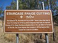
Staircase Range Cutting, near Springsure, Queensland - information sign
-
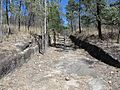
Staircase Range Cutting, near Springsure, Queensland
-
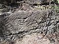
Staircase Range Cutting, near Springsure, Queensland - detail of hand tooling


