
St. Peter's, Nova Scotia facts for kids
Quick facts for kids
St. Peter's
Gaelic: Baile Pheadair
|
|
|---|---|
 |
|
| Nickname(s):
Gateway to the Bras d'Or
The Village on the Canal Where the Ocean meets the Inland Sea |
|

St. Peter's, Nova Scotia
Location in Nova Scotia

St. Peter's, Nova Scotia
Location in Canada
|
|
| Country | Canada |
| Province | Nova Scotia |
| Municipality | Richmond County |
| Founded | 1650 |
| Area | |
| • Total | 346.8 km2 (133.9 sq mi) |
| Highest elevation | 38 m (125 ft) |
| Lowest elevation | 0 m (0 ft) |
| Population
(2001)
|
|
| • Total | 2,634 |
| • Density | 7.6/km2 (20/sq mi) |
| Time zone | UTC-4 (AST) |
| Postal code span |
B0E 3B0
|
| Area code(s) | 902 |
| Telephone Exchange | 535, 785 |
| Website | visitstpeters.com |
St. Peter's is a small village in Nova Scotia, Canada. It is located on Cape Breton Island in Richmond County. The village has had several names over time, including "Santo Pedro" and "Saint-Pierre."
St. Peter's is built on a narrow strip of land called an isthmus. This land separates the southern part of Bras d'Or Lake (St. Peter's Inlet) from St. Peter's Bay on the Atlantic Ocean. A special waterway called the St. Peters Canal cuts through this land. Today, the canal is mostly used by pleasure boats.
The village is home to Battery Provincial Park. This park sits on a hill overlooking St. Peter's Bay, right next to the St. Peter's Canal National Historic Site. It has a small beach, a picnic area, and hiking trails.
St. Peter's is also on Trunk 4, a main highway in the province. There are plans to extend Highway 104 to Sydney. This new highway will become part of the Trans-Canada Highway on Cape Breton Island.
The Nicolas Denys Museum is in the village, but it is only open during the summer months. St. Peter's used to have a train line, but it was closed in the early 1980s.
Contents
A Look Back: History of St. Peter's
Early European Settlements (1630-1758)

St. Peter's is one of the oldest European settlements in North America. Before the French arrived, it was a Portuguese trading and fishing spot called Santo Pedro in the 1500s. The Portuguese left in the early 1600s.
In the 1630s, French merchants from La Rochelle, France, took over. They built a small fort called Saint-Pierre. In 1650, a merchant named Nicolas Denys took control. He encouraged the fur trade with the local Mi'kmaq Nation. The Mi'kmaq used the isthmus as a route to carry their canoes between the Atlantic Ocean and Bras d'Or Lake. Denys also used this path to move small sailing ships across the land.
A Raid on Saint-Pierre (1653)
In 1653, a man named Emmanuel Le Borgne attacked Saint-Pierre with 100 men. He also raided other places like Pentagouet and LaHave. Denys was captured and sent back to France.
After Denys left in 1669, Europeans did not settle here again until 1713. That's when the French built Fortress of Louisbourg and re-established Saint-Pierre.
French Return and Rebuild (1713)

In 1713, France lost control of mainland Nova Scotia to Britain in the Treaty of Utrecht. France then moved some Acadian colonists to Île Royale (now Cape Breton Island). This was to help populate their remaining French lands.
A new settlement called Port Toulouse was created by Jean-Baptiste Hertel de Rouville. It was named after Louis Alexandre, Count of Toulouse. Port Toulouse was built near the old Saint-Pierre site. It served as a supply center for the Fortress of Louisbourg. To protect Port Toulouse, Rouville built another fort called Point Jérome. Rouville was a military officer known for leading raids on settlements in New England.
The French also built Fort St. Anne at Englishtown. These forts helped support the Fortress of Louisbourg.
Battles at St. Peter's

During King George's War, the village was attacked in the Siege of Port Toulouse in 1745. This happened just before the Siege of Louisbourg (1745).
In 1752, during Father Le Loutre's War, Mi'kmaq people at St. Peter's seized two ships. They took 21 prisoners and held them for ransom.
During the French and Indian War, after the final Siege of Louisbourg (1758), the British destroyed the forts at Port Toulouse. The rest of Île Royale then became a British colony.
Under British Rule (1758-1867)

After Louisbourg fell in 1758, French officer Boishébert retreated. He brought many Acadians from the Port Toulouse area to a safe place at Beaubears Island.
After the war, Britain encouraged settlers and soldiers to move to the Port Toulouse area.
In 1793, France declared war on Great Britain. In response, Britain built Fort Dorchester. This fort was on Mount Granville, a hill overlooking the isthmus.
The village of St. Peter's was founded in the early 1800s. Local people fixed up Denys's old "haulover road." They laid down wooden skids to help move small sailing ships across the land. Traveling through Bras d'Or Lake was seen as a shorter and safer way to Sydney. It avoided the rough southern coast of Cape Breton Island.
In 1825, a study looked into building a canal. Construction of the St. Peters Canal began in 1854. It took 15 years to dig and blast through a solid granite hill. The channel is about 20 meters (66 feet) high and 800 meters (2,625 feet) long. It is about 30 meters (100 feet) wide. The canal opened in 1869, just as the industrial age began on Cape Breton Island. Because the tide can be different on each side, a special double-lock system was built. This system helps control the water levels. It is the only one of its kind in North America.
The World Wars and Beyond
The canal's walls were lined with wood, and locks were put at each end. Changes to the canal continued until 1917. The canal was used a lot by small steamships and barges. This was especially true during the First and Second World Wars. Coal from the Sydney Coal Field was moved along this protected inland route to avoid U-boats. A marble quarry at Marble Mountain also used the canal for shipping.
The canal was named a National Historic Site in 1929. The federal government then took over its operation. Parks Canada is now in charge of its upkeep. In 1985, they did a big project to restore both entrances to the canal. After the wars, commercial ships mostly stopped using the canal. Now, it is almost only used by pleasure boats, especially sailboats. Cruising Bras d'Or Lake has become very popular.
Parks Canada operates the canal from May to October each year. Ships using the canal must fit through the lock. The lock is 91.44 meters (300 feet) long, 14.45 meters (47.4 feet) wide, and has a depth of 4.88 meters (16 feet). The old ruins of Nicholas Denys's Fort Saint-Pierre are near the lockmaster's house. The ruins of Fort Dorchester are on Mount Granville, which overlooks the Atlantic side of the canal.
Important Historic Places
St. Peter's has two National Historic Sites:
- St. Peters National Historic Site, which includes the old remains of Fort Saint-Pierre and Port-Toulouse.
- St. Peters Canal National Historic Site.
The Lockmaster's House, built in 1876, is a Recognized Federal Heritage Building. The MacAskill House, built around 1870, is a Provincially Registered Property. This house is where the famous photographer Wallace MacAskill was born. The Fort Toulouse Archaeological Site is protected under a provincial law called the Special Places Protection Act.
Images for kids
-
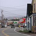
Downtown St. Peter's.
