St Minver facts for kids
Quick facts for kids St Minver
|
|
|---|---|
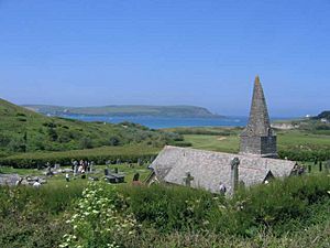
 St Enodoc Church |
|
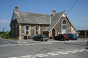
 Perceval Institute |
|
| Lua error in Module:Location_map at line 530: Unable to find the specified location map definition: "Module:Location map/data/Cornwall (mainland)" does not exist. | |
| Population | 2,393 (Civil Parish, 2011) |
| OS grid reference | SW 965 771 |
| Unitary authority | |
| Ceremonial county | |
| Region | |
| Country | England |
| Sovereign state | United Kingdom |
| Post town | WADEBRIDGE |
| Postcode district | PL27 |
| Dialling code | 01208 |
| Police | Devon and Cornwall |
| Fire | Cornwall |
| Ambulance | South Western |
| EU Parliament | South West England |
| UK Parliament |
|
St Minver (called Cornish: Sen Menvra in Cornish) is a village and a large area in north Cornwall, England. It includes both a church area (ecclesiastical parish) and a local government area (civil parish).
The civil parish of St Minver is split into two main parts. These are St Minver Highlands to the north and east, and St Minver Lowlands to the west.
The whole St Minver area has natural borders. To the south and west, it meets the River Camel estuary. The Atlantic coast forms its northern edge. To the east, it borders the parishes of St Endellion and St Kew. In 2011, about 2,393 people lived in St Minver.
Contents
Exploring St Minver's Villages
The St Minver area is home to several villages. The main ones are the village of St Minver itself, Rock, Trebetherick, and Polzeath. Other smaller places include Tredrizzick, Penmean, Splatt, Porthilly, Pityme, and Trevanger.
St Minver village is built around a small square. This square is where two local roads meet. It is about 3 miles (5 km) north of Wadebridge. The village is also close to the B3314 road, which goes from Wadebridge to Delabole.
A holiday park is located near the edge of St Minver village. It used to be part of the Haven brand.
Historic Churches of St Minver
The village of St Minver is easy to spot because of the tall spire of St Menefreda's church. This is the main church for the parish. It is named after Saint Menwreda. She was one of the 24 children of St Brychan, a Welsh king. This saint's name is where "St Minver" comes from today. Inside the church, you can find a brass memorial for Roger Opy, from 1517.
There are two other important churches in the St Minver Lowlands area.
St Enodoc Church
St Enodoc church is found between Rock and Trebetherick. It was built in the 1400s on sandy coastal sand dunes, called "towans." Over time, the church slowly got buried by the moving sand.
In the 1860s, the church was restored and dug out. Today, it stands in the middle of a golf course, which looks quite unusual. John Betjeman, a famous English poet, is buried in the churchyard here.
St Michael's Church
St Michael's church is located on the south side of Porthilly Cove. This cove is an inlet of the River Camel, just south of Rock. This church was also greatly restored in the 1860s.
Quaker Meeting House and Burial Ground
St Minver once had a meeting house and burial ground for the Quakers. The walled Quaker burial ground near Treglines was used between 1665 and 1742. Twenty-eight burials are recorded there. This special ground has no headstones, only trees. The walls of this historic burial ground are protected by English Heritage.
Cornish Wrestling Tradition
Cornish wrestling tournaments have taken place in St Minver. These events have been held at different spots, including the Cricket club.
John Collings (1783-1869) from Porteath in St Minver was a very good wrestler when he was younger. He also had a famous wrestling brother named Thomas.
Colin Meneer, also from St Minver, was a featherweight wrestling champion. He won titles in 1963, 1966, and 1968.
 | Shirley Ann Jackson |
 | Garett Morgan |
 | J. Ernest Wilkins Jr. |
 | Elijah McCoy |

