Starr County, Texas facts for kids
Quick facts for kids
Starr County
|
||
|---|---|---|
|
County
|
||

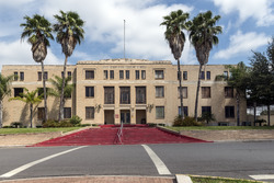
The Starr County Courthouse in Rio Grande City
|
||
|
||

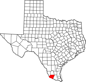
Location within the U.S. state of Texas
|
||
 Texas's location within the U.S. |
||
| Country | ||
| State | ||
| Founded | 1848 | |
| Named for | James Harper Starr | |
| Seat | Rio Grande City | |
| Largest city | Rio Grande City | |
| Area | ||
| • Total | 1,229 sq mi (3,180 km2) | |
| • Land | 1,223 sq mi (3,170 km2) | |
| • Water | 88.5 sq mi (229 km2) 0.5%% | |
| Population
(2020)
|
||
| • Total | 65,920 | |
| • Density | 53.637/sq mi (20.709/km2) | |
| Time zone | UTC−6 (Central) | |
| • Summer (DST) | UTC−5 (CDT) | |
| Congressional district | 28th | |
Starr County is a county located in the southern part of Texas, a state in the United States. In 2020, about 65,920 people lived here. The main city and county seat is Rio Grande City. Starr County was created in 1848. It was named after James Harper Starr, who was an important leader in the early days of the Republic of Texas.
This county is part of the Rio Grande City area, which includes other small towns. It's also part of the larger Rio Grande Valley region. Starr County is right next to the border with Mexico.
Most of the people living in Starr County are of Hispanic or Latino background. About 97.7% of the population identifies this way. This makes Starr County the place with the highest percentage of Hispanic people in the main part of the United States.
Contents
History of Starr County
Starr County has grown quite a bit over the years. For example, between 2000 and 2010, the number of people living here increased from 53,597 to 60,968. This shows that more and more families are choosing to make Starr County their home.
Geography and Location
Starr County covers a total area of about 1,229 square miles (3,183 square kilometers). Only a small part of this area, about 5.9 square miles (15 square kilometers), is covered by water.
Main Roads in Starr County
Neighboring Areas
Starr County shares its borders with several other counties in Texas and some cities in Mexico:
- Jim Hogg County (to the north)
- Brooks County (to the northeast)
- Hidalgo County (to the east)
- Zapata County (to the northwest)
- Camargo Municipality, Tamaulipas, Mexico (to the south)
- Guerrero, Tamaulipas, Mexico (to the northwest)
- Gustavo Díaz Ordaz, Tamaulipas, Tamaulipas, Mexico (to the south)
- Mier Municipality, Tamaulipas, Mexico (to the south)
- Miguel Alemán Municipality, Tamaulipas, Mexico (to the south)
Protected Natural Areas
Part of the Lower Rio Grande Valley National Wildlife Refuge is located in Starr County. This refuge helps protect important wildlife and their habitats in the region.
People of Starr County
The number of people living in Starr County has changed over time. Here's a quick look at the population from different years:
| Historical population | |||
|---|---|---|---|
| Census | Pop. | %± | |
| 1860 | 2,406 | — | |
| 1870 | 4,154 | 72.7% | |
| 1880 | 8,304 | 99.9% | |
| 1890 | 10,749 | 29.4% | |
| 1900 | 11,469 | 6.7% | |
| 1910 | 13,151 | 14.7% | |
| 1920 | 11,089 | −15.7% | |
| 1930 | 11,409 | 2.9% | |
| 1940 | 13,312 | 16.7% | |
| 1950 | 13,948 | 4.8% | |
| 1960 | 17,137 | 22.9% | |
| 1970 | 17,707 | 3.3% | |
| 1980 | 27,266 | 54.0% | |
| 1990 | 40,518 | 48.6% | |
| 2000 | 53,597 | 32.3% | |
| 2010 | 60,968 | 13.8% | |
| 2020 | 65,920 | 8.1% | |
| U.S. Decennial Census 1850–2010 2010–2014 |
|||
Population in 2020
In 2020, there were 65,920 people living in Starr County. There were 16,281 households, which are groups of people living together in one home. Out of these, 12,836 were families.
Most people in Starr County are of Hispanic or Latino background. In 2020, about 97.68% of the population identified as Hispanic or Latino. This is the highest percentage of Hispanic residents in any county in the main United States.
The median age in Starr County in 2000 was 26 years old. This means half the people were younger than 26 and half were older. Many young people live here, with about 37.4% of the population being under 18 years old.
Economy and Jobs
Starr County is well-known for its farming. Farmers here grow a lot of oilseeds, which are used to make cooking oils, and dry beans. It's one of the top counties in Texas for producing these crops.
Education in Starr County
Students in Starr County attend schools in different school districts, depending on where they live:
- If you live in eastern Starr County, you would go to schools in the Rio Grande City Consolidated Independent School District.
- If you live in western Starr County, you would go to schools in the Roma Independent School District.
- If you live in northeastern Starr County, you would go to schools in the San Isidro Independent School District.
There is also a Catholic school in Rio Grande City called Immaculate Conception School. It was started in 1884 and teaches students from pre-kindergarten through eighth grade.
For higher education, all of Starr County is served by South Texas College. This college provides learning opportunities for people after high school.
Communities in Starr County
Starr County has several towns and many smaller communities. Many families have moved to these smaller communities, often called colonias.
Cities in Starr County
- Escobares
- La Grulla
- Rio Grande City (This is the county seat, the main city where the county government is located.)
- Roma
Unincorporated Communities
These are smaller communities that are not officially part of a city:
Census-Designated Places (CDPs)
Starr County has many census-designated places, which are areas identified by the U.S. Census Bureau for statistical purposes. Some examples include:
- Airport Heights
- Alto Bonito Heights
- Amada Acres
- Anacua
- Barrera
- Buena Vista
- Casa Blanca
- Chaparrito
- Delmita
- El Brazil
- El Castillo
- El Refugio
- Falcon Heights
- Fronton
- Garceno
- Garciasville
- La Casita
- La Escondida
- La Rosita
- Las Lomas
- Los Alvarez
- Los Ebanos
- Mi Ranchito Estate
- North Escobares
- Palo Blanco
- Quesada
- Ranchitos del Norte
- Rancho Viejo
- Salineño
- San Isidro
- Santa Cruz
- Tierra Dorada
- Valle Hermoso
Images for kids
See also
 In Spanish: Condado de Starr para niños
 | James Van Der Zee |
 | Alma Thomas |
 | Ellis Wilson |
 | Margaret Taylor-Burroughs |


