
Great Otway National Park facts for kids
Quick facts for kids Great Otway National ParkVictoria |
|
|---|---|
|
IUCN Category II (National Park)
|
|

Lake Elizabeth, formed from a landslide in August 1953, it broke its banks allowing the West Barwon River to flow.
|
|

Great Otway National Park
Location in Victoria
|
|
| Nearest town or city | Apollo Bay |
| Established | 11 December 2005 |
| Area | 103 km2 (39.8 sq mi) |
| Managing authorities | Parks Victoria |
| Website | Great Otway National Park |
| See also | Protected areas of Victoria |

The Great Otway National Park is a huge national park in Victoria, Australia. It's located in a region called Barwon South West. The park covers about 103,185 hectares (that's over 250,000 acres!). It's about 162 kilometers (100 miles) southwest of Melbourne. This amazing park has lots of different landscapes and plants. It is found within the beautiful Otway Ranges mountains.
Contents
History of Great Otway National Park
The forests in the Otway area have a long history of logging. People have been cutting down trees for timber for over 150 years. The busiest time for logging was in 1961, but it has slowed down since then. The tall forests you see today show how long it takes for these giant trees to grow back.
Wildfires have burned through the park many times over the years. These fires help shape the types of plants and animals that live there. The last big fire was on Ash Wednesday in 1983.
The Great Otway National Park was officially created in 2004. Before that, it was several smaller parks and forest areas. These included Otway National Park, Angahook-Lorne State Park, and Melba Gully State Park. Local people and environmental groups worked hard to combine them into one big park. The park was officially announced on December 11, 2005.
Exploring the Great Otway National Park
The park is a very popular place for tourists from Australia and other countries. Many companies offer tours to explore the area. You can find three main camping areas inside the park. These are at Johanna, Aire River, and Blanket Bay.
You can get to the park from different directions. From the east, you can come through Apollo Bay. From the north, you can enter near Forrest or Beech Forest. If you're coming from the west, you can use Princetown.
The park includes both beautiful coastline and thick forests in the Otway Ranges. This means you can enjoy beaches and forest trails. The park and the Aire River campground are home to many koalas. The Cape Otway Lighthouse is right next to the park. You can visit it during the week. If you're lucky, you might see migrating whales and dolphins from the coast. These include southern right whales, humpback whales, and bottlenose dolphins.
Glow Worms in the Park
At night, you can see amazing glow worms in the park. These are the larvae (baby stage) of small flies called fungus gnats. They glow in the dark! You can spot them along stream banks and walking tracks. Some great places to see them are Angahook-Lorne State Park, Beauchamp Falls, Hopetoun Falls, Stevenson Falls, and Melba Gully State Park.
Important Bird Areas
BirdLife International has named the Great Otway National Park an Important Bird Area (IBA). This means it's a special place for birds. The park is home to many bird species. These include rufous bristlebirds, striated fieldwrens, and pink robins.
Climate in the Otway Ranges
The weather in the Otway Ranges is cool and very wet. This is especially true during winter. This is because of its location, which gets a lot of westerly winds. Heavy, wet snowfalls often happen on the higher mountains. For example, Mount Cowley is about 670 meters (2,200 feet) above sea level.
The climate data for the Otway Ranges comes from Weeaproinah. This location is about 492 meters (1,614 feet) above sea level. Data was collected there between 1965 and 2012.
| Climate data for Weeaproinah (1965–2012); 492 m AMSL; 38° 38′ 08.52″ S | |||||||||||||
|---|---|---|---|---|---|---|---|---|---|---|---|---|---|
| Month | Jan | Feb | Mar | Apr | May | Jun | Jul | Aug | Sep | Oct | Nov | Dec | Year |
| Record high °C (°F) | 39.4 (102.9) |
39.0 (102.2) |
35.9 (96.6) |
28.5 (83.3) |
22.8 (73.0) |
16.2 (61.2) |
16.4 (61.5) |
20.3 (68.5) |
25.4 (77.7) |
28.1 (82.6) |
32.0 (89.6) |
36.5 (97.7) |
39.4 (102.9) |
| Mean daily maximum °C (°F) | 20.0 (68.0) |
20.6 (69.1) |
18.3 (64.9) |
15.0 (59.0) |
11.9 (53.4) |
9.6 (49.3) |
8.8 (47.8) |
9.8 (49.6) |
11.4 (52.5) |
13.7 (56.7) |
16.0 (60.8) |
17.9 (64.2) |
14.4 (57.9) |
| Mean daily minimum °C (°F) | 10.8 (51.4) |
11.5 (52.7) |
10.5 (50.9) |
8.8 (47.8) |
7.2 (45.0) |
5.4 (41.7) |
4.5 (40.1) |
4.7 (40.5) |
5.4 (41.7) |
6.6 (43.9) |
8.1 (46.6) |
9.4 (48.9) |
7.7 (45.9) |
| Record low °C (°F) | 3.8 (38.8) |
4.1 (39.4) |
3.0 (37.4) |
1.3 (34.3) |
−0.1 (31.8) |
−0.5 (31.1) |
−0.5 (31.1) |
−0.6 (30.9) |
−0.6 (30.9) |
−0.5 (31.1) |
−0.1 (31.8) |
3.2 (37.8) |
−0.6 (30.9) |
| Average precipitation mm (inches) | 87.8 (3.46) |
85.8 (3.38) |
111.7 (4.40) |
154.6 (6.09) |
197.1 (7.76) |
211.7 (8.33) |
226.3 (8.91) |
233.9 (9.21) |
199.9 (7.87) |
174.0 (6.85) |
139.3 (5.48) |
113.3 (4.46) |
1,935.4 (76.2) |
| Average precipitation days (≥ 0.2 mm) | 12.8 | 11.8 | 15.6 | 18.1 | 20.7 | 21.5 | 23.4 | 23.1 | 21.1 | 19.8 | 16.7 | 14.8 | 219.4 |
| Source: Australian Bureau of Meteorology; Weeaproinah | |||||||||||||
Fungi in the Great Otway National Park
The Great Otway National Park has a huge variety of fungi. While many plants and animals are listed in the park's management plan, fungi are rarely mentioned. However, most fungi are very important for the environment. They play positive roles in keeping the ecosystem healthy.
Fungi help break down dead leaves and branches. This process, called decomposition, releases important nutrients back into the soil. These nutrients then help other plants and organisms grow. Many plants in the park, and around the world, also have a special relationship with fungi. This is called a mycorrhizal relationship. The fungi help the plants get nutrients, and the plants provide food for the fungi. It's a win-win!
Because the park has so many different plants, habitats, and climates, it's expected to have many types of fungi. This includes lichens, which are a mix of fungi and algae. The Atlas of Living Australia lists 278 species of fungi in the park. But this is probably only a small part of all the fungi that actually live there.
Even though fungi are super important for ecosystems, they are often overlooked. Australia has plans to protect its biodiversity (all the different living things). But most of these plans don't focus much on fungi. Luckily, many local people are very interested in fungi. The Southern Otways Landcare Network has been studying the park's fungi. They even made a guide to 100 common types you can easily spot.
Fungimap is an Australian group where everyday people help scientists. They are mapping where different fungi grow, including those in the Great Otway National Park.
Cool Fungi to Spot
One tiny but colorful fungus in the wetter parts of the park is the ruby bonnet (Mycena viscidocruenta). Another easy-to-spot fungus is the ghost fungus (Omphalotus nidiformis). It grows on trees and glows a pale green at night! The rosette fungus (Podoscypha petalodes) often looks like funnel-shaped flowers. You can find it at the bottom of trees and among fallen leaves. The flame fungus (Clavaria miniata) grows on the soil, either alone or in groups.
-
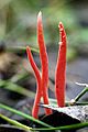
Clavaria miniata
-
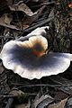
Omphalotus nidiformis
-
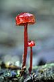
Mycena viscidocruenta
-
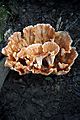
Podoscypha petalodes


Images for kids
-
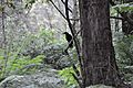
Pied Currawong on the walk to Triplet Falls

See also
 In Spanish: Parque nacional Gran Otway para niños
