Stob Bàn (Mamores) facts for kids
Quick facts for kids Stob Bàn |
|
|---|---|

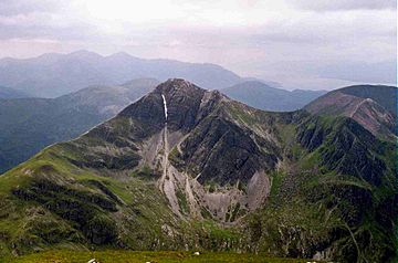
Stob Bàn and its north eastern face seen from Sgurr a' Mhàim 2.5 km to the NE.
|
|
| Highest point | |
| Elevation | 999 m (3,278 ft) |
| Prominence | c. 234 m |
| Parent peak | Sgurr a' Mhàim |
| Listing | Munro, Marilyn |
| Naming | |
| English translation | White Peak |
| Language of name | Gaelic |
| Pronunciation | English approximation: STOP-bahn |
| Geography | |
| Location | Highland, Scotland |
| Parent range | Mamores |
| OS grid | NN147654 |
| Topo map | OS Landranger 41, OS Explorer 392 |
Stob Bàn is a cool mountain in Scotland. It's found at the west end of the Mamores mountain range. This peak is about 5.5 kilometers (3.4 miles) northwest of Kinlochleven.
Stob Bàn stands tall at 999 meters (3,278 feet). Because it's over 3,000 feet, it's called a Munro. Munros are Scottish mountains that are at least 3,000 feet high. Stob Bàn looks special from Glen Nevis. It has a sharp top and white rocks that look like snow. Its name means "White Peak" in Gaelic.
Contents
Discovering Stob Bàn's Geology
Stob Bàn is important for its amazing Dalradian rock formations. These rocks are very old. They formed in the high lands east and south of Scotland's Great Glen.
Experts from the Joint Nature Conservation Committee (JNCC) study these rocks. They have marked Stob Bàn as a key site for geology. It helps us understand Earth's history.
It's good to know there's another mountain called Stob Bàn. That one is also a Munro. But it's in a different area called the Grey Corries.
Exploring Stob Bàn's Ridges
Stob Bàn has three main ridges, which are like long, narrow mountain tops.
East and West Ridges
The east ridge connects to Sgor an Iubhair. This used to be a Munro too. The path goes over the top of Coire a' Mhusgain. This name means "Corrie of the Shellfish."
The western ridge links to another Munro. This one is called Mullach nan Coirean.
Northern and Southern Ridges
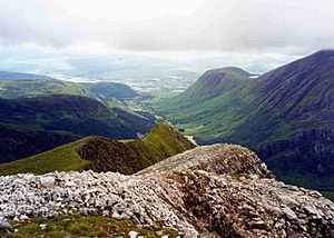
The northern ridge drops steeply down to Glen Nevis. It has many rocky steps.
There's also a smaller fourth ridge. This one goes steeply southwest. It leads to the West Highland Way. This path is a quick way down for hikers coming from the south.
Hikers sometimes climb Stob Bàn as part of the Highland High Way. This is a higher route of the West Highland Way. On sunny days, people often hike over some Mamores peaks. They do this on the last day between Kinlochleven and Fort William.
Stob Bàn's Striking Features
Stob Bàn has very steep cliffs on its northeastern side. These cliffs drop over 400 meters (1,300 feet) into Coire a' Mhusgain. These cliffs make the mountain look like a classic pyramid.
Winter Climbing Challenges
The rocky parts on the northern ridge are popular for ice climbing in winter.
The South Buttress has several good routes for winter climbing. The Central Buttress offers three gully lines. It also has a rocky rib and an arête. These are all good winter climbs on broken rock.
How to Climb Stob Bàn
Most people start their climb from Glen Nevis to the north.
Direct Ascents
One way to climb is to start at Achriabhach. From there, you follow a path used by deer stalkers. This path goes up Coire a' Mhusgain. It reaches the low point between Stob Bàn and Sgor an Iubhair. Then, you climb steeply up the eastern ridge to the top.
You can also start from the same spot. Then, you can climb the rough northern ridge. On this route, there's a false top at 900 meters (2,950 feet). Many people think this is the real summit.
Combining Peaks
Stob Bàn is often climbed with its neighbor, Mullach nan Coirean. Mullach nan Coirean is about three kilometers (1.9 miles) to the west.
From the summit of Stob Bàn, you get amazing views. You can see Ben Nevis, Scotland's highest mountain. You can also see the Aonachs.
 | John T. Biggers |
 | Thomas Blackshear |
 | Mark Bradford |
 | Beverly Buchanan |


