Stob a' Choire Odhair facts for kids
Quick facts for kids Stob a' Choire Odhair |
|
|---|---|

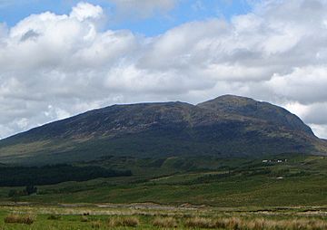
Stob a' Choire Odhair seen from the SE. The slopes of Beinn Toaig are in front with the main summit behind.
|
|
| Highest point | |
| Elevation | 945 m (3,100 ft) |
| Prominence | 277 m (909 ft) |
| Listing | Munro, Marilyn |
| Naming | |
| English translation | Peak of the dun-coloured Corrie |
| Language of name | Gaelic |
| Geography | |
| Location | Argyll, Scotland |
| Parent range | Grampians |
| OS grid | NN257459 |
| Topo map | OS Landranger 50, OS Explorer 377 |
Stob a' Choire Odhair is a Scottish mountain located about eight kilometres (about 5 miles) northwest of Bridge of Orchy. It sits right on the edge of the Argyll and Bute and Highland areas in Scotland.
Contents
Discovering Stob a' Choire Odhair
Stob a' Choire Odhair is a mountain that stands 945 metres (about 3,100 feet) tall. It's known as both a Munro and a Marilyn. In Scotland, a Munro is a mountain over 3,000 feet (914.4 metres) high, and a Marilyn is a hill with a drop of at least 150 metres (about 492 feet) on all sides.
This mountain is often seen with its taller neighbour, Stob Ghabhar. Both mountains are part of the Black Mount deer forest. This area gets its name from the dark, peaty ground found there. You can easily spot Stob a' Choire Odhair and Stob Ghabhar from the A82 road as it crosses Rannoch Moor. Many hikers enjoy climbing both mountains together in one day. The name "Stob a' Choire Odhair" comes from the Gaelic words meaning "Peak of the dun-coloured corrie" (a corrie is a bowl-shaped valley).
Mountain Features
The top of Stob a' Choire Odhair is where three different ridges meet.
- One ridge goes west and connects to Stob Ghabhar, another Munro about three kilometres (nearly 2 miles) away. There's a dip, called a col, between them that is 668 metres high.
- The northeast ridge drops very steeply down to the flat, open land of the Black Mount and Rannoch Moor.
- The southeast ridge leads to a smaller peak called Beinn Toaig, which is 834 metres (about 2,736 feet) high. There's another col here, 802 metres (about 2,631 feet) high.
On either side of the 802-metre col, you'll find two corries. To the north is Coire Odhair, and to the south is Coire Toaig. Coire Toaig has a good path that leads directly up to the main summit of Stob a' Choire Odhair.
Exploring Historic Routes
The lower eastern slopes of Stob a' Choire Odhair are home to two very old roads. These roads were once super important for connecting to the north of Scotland.
The Military Road
One of these is an old military road. It was built in the early 1750s by Major William Caulfeild. This road was part of an effort to bring peace to the Highlands after the 1745 Jacobite rising. The Jacobite rising was a time when people tried to put a different king on the throne of Great Britain.
The Drovers' Road
A bit further east, you can find the path of an ancient drovers' road. Drovers used these roads to move cattle to markets. In 1803, a famous engineer named Thomas Telford improved this road. For many years, it was the main road that went through Glen Coe all the way to Fort William. However, in 1933, a new road was built further east. Today, Telford's old road is part of the West Highland Way, a popular long-distance walking trail.
Climbing Stob a' Choire Odhair
Most people who climb Stob a' Choire Odhair also climb Stob Ghabhar, its neighbour. A common starting point for this adventure is Victoria Bridge, located at the western end of Loch Tulla.
The easiest way to reach the summit from here is by following a good zig-zag path up Coire Toaig. You can also include climbing Stob a' Choire Odhair as part of a longer hike called the Clachlet Traverse. This high-level route goes from the Inveroran Hotel near Bridge of Orchy to the Kings House Hotel in Glen Coe. Even though Stob a' Choire Odhair is not as tall as Stob Ghabhar, it offers amazing views across Rannoch Moor and the other mountains around Bridge of Orchy.
 | Aaron Henry |
 | T. R. M. Howard |
 | Jesse Jackson |


