
Summerland, California facts for kids
Quick facts for kids
Summerland, California
|
|
|---|---|

Summerland, as seen from the top of Ortega Hill, 2006
|
|

Location in Santa Barbara County and the state of California
|
|
| Country | |
| State | |
| County | Santa Barbara |
| Area | |
| • Total | 1.990 sq mi (5.152 km2) |
| • Land | 1.983 sq mi (5.135 km2) |
| • Water | 0.007 sq mi (0.017 km2) 0.33% |
| Elevation | 121 ft (37 m) |
| Population | |
| • Total | 1,448 |
| • Density | 727.6/sq mi (281.06/km2) |
| Time zone | UTC-8 (Pacific) |
| • Summer (DST) | UTC-7 (PDT) |
| ZIP code |
93067
|
| Area code | 805 |
| FIPS code | 06-75714 |
| GNIS feature ID | 1656637 |
Summerland is a small community located in Santa Barbara County, California. It is called a census designated place (CDP), which means it's a special area defined for collecting population data. In 2010, about 1,448 people lived there.
Summerland has its own school and a church. You can also find many small businesses in the town. It's known for its beautiful coastal views and interesting history.
Contents
History of Summerland
Summerland has a long and interesting past. Long ago, the Chumash people used natural tar from oil seeps in the area. They used this tar to seal their ocean-going canoes called tomols. Later, the Mission Santa Barbara also used this tar to waterproof its roof.
Founding of the Town
In 1883, a man named H.L. Williams founded Summerland. He was a real estate developer and believed in Spiritualism. This was a movement where people believed they could talk to spirits. In 1888, Williams divided his land into many small plots. He sold these plots to other Spiritualists, who moved to the area. The main spiritual building in town was a Spiritualist Church. Sadly, this church was taken down in the 1950s when Highway 101 was built.
Oil Discovery and Production
In the 1890s, oil was discovered near Summerland's coast. Many wooden oil derricks (towers used for drilling) were built on the beach and on piers reaching into the ocean. This area became famous for having the world's first offshore oil well, which drilled directly into the sea floor!
Oil production from the beach area was highest before 1910. Most of the oil rigs stayed until the 1920s. Oil continued to be pumped from the nearby land until 1930. The last oil from the nearshore area was pumped in 1940.


Later Oil Discoveries and Environmental Concerns
In 1957, a company called Standard Oil (now Chevron) found a large oil field several miles offshore from Summerland. This field was closed down in the 1990s.
In January 1969, a big oil spill happened about five miles offshore. This event, known as the Santa Barbara Oil Spill, was very important. It helped start the modern environmental movement, making people more aware of protecting nature.
More recently, in August 2015, Summerland's beach was closed for a few days. This happened because a lot of oil washed ashore. Local people think the oil came from an old, capped oil well near Lookout Park that might be leaking.
Geography and Location
Summerland is located right on the coast at 34°25′17″N 119°35′45″W / 34.42139°N 119.59583°W. It is east of Montecito and west-northwest of Carpinteria. Summerland is built on coastal bluffs right next to the ocean.
The community is quite small. According to the United States Census Bureau, Summerland covers about 2.0 square miles (5.2 square kilometers). Most of this area is land, with a very small amount of water. U.S. Route 101, a major highway, passes through Summerland.
Climate in Summerland
Summerland has a pleasant climate. It experiences warm, dry summers, but they are not too hot. The average monthly temperatures do not go above 71.6°F (22°C). This type of weather is known as a warm-summer Mediterranean climate.
Population and People
Let's look at who lives in Summerland.
2010 Census Information
In 2010, the population of Summerland was 1,448 people. This means there were about 728 people living in each square mile.
Most of the people living in Summerland were White (89.4%). There were also smaller numbers of Asian (2.8%), Native American (0.5%), African American (0.2%), and Pacific Islander (0.4%) residents. About 13.3% of the population was Hispanic or Latino.
There were 687 households in Summerland. About 18.6% of these households had children under 18 living there. The average household had about 2.11 people. The median age in Summerland was 49.2 years old. This means half the people were younger than 49.2, and half were older.
Summerland in Popular Culture
Summerland has been featured in different forms of entertainment:
- The band Everclear has a song called "Summerland" on their album Sparkle and Fade.
- It is the main setting for the T.V. show Summerland.
- The band King's X has a song titled "Summerland" on their album Gretchen Goes to Nebraska.
- The science fiction movie The Space Between Us features Summerland in its important final scenes.
- The indie pop/rock group half•alive also has a song called "Summerland".
Notable Residents
Some well-known people have lived in Summerland:
- Julian Ritter, an artist.
- Harry Thomason, a film and television director and producer.
Images for kids
-
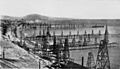
Oil wells just off the coast, before 1906
-
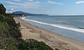
The same view in 2009
See also
 In Spanish: Summerland (California) para niños
