Taylor Mill, Kentucky facts for kids
Quick facts for kids
Taylor Mill, Kentucky
|
|||
|---|---|---|---|
|
|||
| Motto(s):
"Taylored with Pride"
|
|||

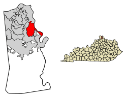
Location in Kenton County, Kentucky
|
|||
| Country | United States | ||
| State | Kentucky | ||
| County | Kenton | ||
| Incorporated | 1956 | ||
| Government | |||
| • Type | Commission | ||
| Area | |||
| • Total | 6.21 sq mi (16.07 km2) | ||
| • Land | 6.11 sq mi (15.83 km2) | ||
| • Water | 0.09 sq mi (0.24 km2) | ||
| Elevation | 827 ft (252 m) | ||
| Population
(2020)
|
|||
| • Total | 6,873 | ||
| • Estimate
(2022)
|
6,846 | ||
| • Density | 1,124.33/sq mi (434.13/km2) | ||
| Time zone | UTC-5 (Eastern (EST)) | ||
| • Summer (DST) | UTC-4 (EDT) | ||
| ZIP code |
41015
|
||
| Area code(s) | 859 | ||
| FIPS code | 21-75738 | ||
| GNIS feature ID | 2405573 | ||
Taylor Mill is a city in Kenton County, Kentucky, in the United States. It is a "home rule-class city," which means it has the power to manage its own local government. In 2020, about 6,873 people lived there.
Contents
History of Taylor Mill
The city of Taylor Mill got its name from a mill that operated there in the early 1800s. This mill was run by James Taylor Jr., who also founded the nearby city of Newport.
In 1810, James Taylor Jr. bought the land where the mill was located. The road leading from what is now Covington to the mill was called Taylor's Mill Road. Soon, other people started moving to the area. They cut down trees for wood and cleared land for farming. This is how the settlement of Taylor Mill began to grow.
City Mergers and Name Changes
In 1959, Taylor Mill grew by adding the former city of Sunny Acres. This was done because the name "Sunny Acres" caused some confusion. People sometimes thought it was connected to a funny episode from the old TV show Maverick called "Shady Deal at Sunny Acres."
Later, in 1972, the people of Taylor Mill and another city called Winston Park voted to join together. This merger helped both communities grow stronger.
Geography of Taylor Mill
Taylor Mill is located in the northeastern part of Kenton County. It shares borders with the city of Covington to the north, west, and south. To the southeast, it borders Fairview and Ryland Heights.
A part of the city stretches along the west side of the Licking River. This river forms the border of Kenton County. On the other side of the river, in Campbell County, are the cities of Wilder and Cold Spring.
Major Roads
Interstate 275, which is a large highway that goes around Cincinnati, passes through the northern part of Taylor Mill. You can get onto I-275 from Exit 79, which is Kentucky Route 16. Kentucky Route 16 goes north about 5 miles to downtown Covington. It also goes southwest about 14 miles to Walton.
Land and Water Area
According to the United States Census Bureau, Taylor Mill covers a total area of about 6.3 square miles (16.3 square kilometers). Most of this area, about 6.1 square miles (15.9 square kilometers), is land. The remaining 0.2 square miles (0.4 square kilometers) is water.
Population and People
In 2010, there were 6,604 people living in Taylor Mill. The city had 2,759 homes, with 134 of them not being lived in.
According to the census from 2000, there were 6,913 people living in the city. Most of the people were White (about 98%). There were also smaller groups of African American, Native American, and Asian residents. About 0.78% of the population was Hispanic or Latino.
There were 2,552 households in 2000. About 37.4% of these households had children under 18 living with them. Most households (62.9%) were married couples living together.
| Historical population | |||
|---|---|---|---|
| Census | Pop. | %± | |
| 1960 | 710 | — | |
| 1970 | 3,146 | 343.1% | |
| 1980 | 4,509 | 43.3% | |
| 1990 | 5,530 | 22.6% | |
| 2000 | 6,913 | 25.0% | |
| 2010 | 6,604 | −4.5% | |
| 2020 | 6,873 | 4.1% | |
| 2022 (est.) | 6,846 | 3.7% | |
| U.S. Decennial Census | |||
The average age of people in Taylor Mill in 2000 was 36 years old. About 26.4% of the population was under 18. About 10.4% of the population was 65 years old or older.
Business in Taylor Mill
Taylor Mill has a special business area located where Interstate 275 meets Taylor Mill Road. This area is called "The Districts of Taylor Mill." It is divided into four different sections for businesses and development.
Schools in Taylor Mill
Students in Taylor Mill attend several schools:
- Taylor Mill Elementary
- Woodland Middle School
- Scott High School
- St. Anthony School
Famous People from Taylor Mill
- Carly Pearce, a country music singer
See also
 In Spanish: Taylor Mill (Kentucky) para niños
 | Precious Adams |
 | Lauren Anderson |
 | Janet Collins |


