
Tech (river) facts for kids
Quick facts for kids Tech |
|
| River | |
 Pont du Diable (Devil's Bridge) over the Tech, at Céret
|
|
| Country | |
|---|---|
| Region | Languedoc-Roussillon |
| Departments | Pyrénées-Orientales |
| Tributaries | |
| - left | Coumelade, Riuferrer, Ample |
| - right | Lamanère, Maureillas, Tanyari |
| Landmark | Pont del Diable of Ceret |
| Source | Roc Colom |
| - location | Prats-de-Mollo-la-Preste, Pyrénées-Orientales, France |
| - elevation | 2,345 m (7,694 ft) |
| - coordinates | 42°25′23″N 3°2′42″E / 42.42306°N 3.04500°E |
| Mouth | Mediterranean Sea |
| - location | to the north of Argelès-sur-Mer, Pyrénées-Orientales, France |
| - elevation | 0 m (0 ft) |
| - coordinates | 42°N 35°E / 42°N 35°EInvalid arguments have been passed to the {{#coordinates:}} function |
| Length | 84.1 km (52 mi) |
| Basin | 721 km² (278 sq mi) |
| Discharge | for Argelès-sur-Mer |
| - average | 8.54 m³/s (302 cu ft/s) |
The Tech (also called Tec in Catalan) is a river in southeastern France. It flows near the border between France and Spain. This river runs through a valley in the Pyrénées-Orientales department. Its river basin is the southernmost in mainland France.
Two towns in the area are named after the river: Le Tech and Arles-sur-Tech.
Contents
River Journey: From Mountains to Sea
The Tech river starts high up in the Pyrenees mountains. Its source is on the eastern side of Roc Colom. This is in the town of Prats-de-Mollo-la-Preste. The river begins at an elevation of about 2,345 meters (7,694 feet).
The river generally flows from the southwest to the northeast. First, it goes through the Vallespir valley, passing by the town of Céret. After that, it flows across the flat Plain of Roussillon.
The Tech river finally empties into the Mediterranean Sea. This happens at the Natural Reserve of Mas Larrieu. This area is also known as the "Mouth of the Tech." It is located north of the town of Argelès-sur-Mer.
River Length and Basin Area
The Tech river is 84.1 kilometers (52.3 miles) long. Its drainage basin covers an area of about 721 square kilometers (278 square miles). The river basin has two main parts:
- A mountain area: This part stretches from the river's source to the town of Céret. Here, you can find many forests on the mountains.
- A flat area: This part goes from Céret all the way to the sea. The river flows through the Plain of Roussillon. This area has many farms where different crops are grown.
River Flow and Protection
Experts have studied the flow of the Tech river for many years. They observed it from 1979 to 2013 in Argelès-sur-Mer. This is a popular tourist town near where the river meets the sea.
The average amount of water flowing in the river at this spot is 8.54 cubic meters per second.
Both the valley of the Tech and its mouth are part of Natura 2000. This is a special ecological network of protected areas. It helps protect nature in the European Union.

Smaller Rivers Joining the Tech
The Tech river has 22 smaller rivers and streams that flow into it. These are called tributaries. Here are some of the longest ones:
- Right tributaries:
- Lamanère, which is 15.7 kilometers long.
- Maureillas, which is 16.1 kilometers long.
- Tanyari, which is 13.3 kilometers long.
- Left tributaries:
- Coumelade, which is 15 kilometers long.
- Riuferrer, which is 17.7 kilometers long.
- Ample, which is 15.7 kilometers long.

Towns and Bridges Along the Tech
The Tech river flows entirely within the Pyrénées-Orientales department in France. It passes through 25 different towns, also known as communes.
Famous Bridge: Pont del Diable
One very famous landmark along the Tech river is the Pont del Diable. This means "Devil's Bridge" in Catalan. It is also called the Pont Vieux, which means "Old Bridge." This historic bridge is located in the town of Céret and crosses over the Tech river.
Images for kids
-
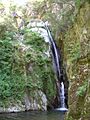
Salt de Maria Valenta fall, Arles-sur-Tech
-
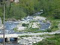
Confluence of the Coumelade and the Tech
-
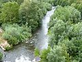
Le Tech river, Céret
-
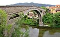
Le Pont du Diable (The Devil's bridge), Céret


See also
 In Spanish: Río Tec para niños
