Céret facts for kids
Quick facts for kids
Céret
|
||
|---|---|---|
The city of Céret
|
||
|
||
| Country | France | |
| Region | Occitanie | |
| Department | Pyrénées-Orientales | |
| Arrondissement | Céret | |
| Canton | Vallespir-Albères | |
| Intercommunality | Communauté de communes du Vallespir | |
| Area
1
|
37.86 km2 (14.62 sq mi) | |
| Population
(2014)
|
7,663 | |
| • Density | 202.40/km2 (524.22/sq mi) | |
| Demonym(s) | Cérétans | |
| Time zone | UTC+01:00 (CET) | |
| • Summer (DST) | UTC+02:00 (CEST) | |
| INSEE/Postal code |
66049 /66400
|
|
| Elevation | 107–1,440 m (351–4,724 ft) (avg. 154 m or 505 ft) |
|
| Website | Official website: http://www.mairie-ceret.fr/ | |
| 1 French Land Register data, which excludes lakes, ponds, glaciers > 1 km2 (0.386 sq mi or 247 acres) and river estuaries. | ||
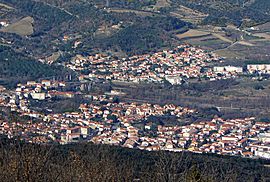
Céret is a charming town in southern France. It's located in the Pyrénées-Orientales department, which is like a county. This town used to be the main city of a historic region called Vallespir in Catalonia.
Céret is also an important administrative center. It's a "subprefecture," meaning it's a main town for a part of the department, called an "arrondissement."
Contents
What's in a Name?
The name Céret comes from the Catalan name for the town, which is Ceret.
Over many years, the town's name has been spelled in different ways. Some old names include vicus Sirisidum (from the year 814) and villa Cerseto (from 915). By the 16th century, Ceret became the most common way to spell it.
Exploring Céret's Location
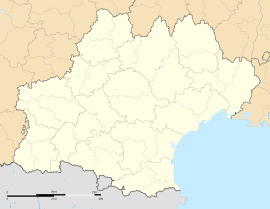
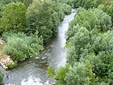
Céret is nestled in the foothills of the Pyrenees mountains in southern France. It sits in the beautiful valley of the Tech river.
The town covers an area of about 37.86 km2 (14.62 sq mi). Its average height above sea level is 154 m (505 ft). The lowest point in the town is 107 m (351 ft) by the Tech river, and the highest point is on a peak called Roc de Frausa, at 1,440 m (4,720 ft).
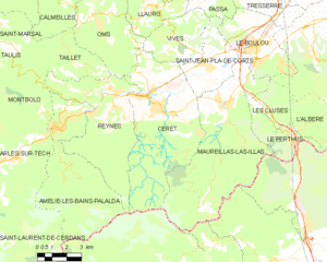
Céret is about 35 km (22 mi) from Perpignan, a larger city. It's also surrounded by other towns like Vivès, Saint-Jean-Pla-de-Corts, Maureillas-las-Illas, Reynès, and Oms. To the south, it borders Spain.
 |
Oms | Vivès | Saint-Jean-Pla-de-Corts |  |
| Reynès | Maureillas-las-Illas | |||
| Maçanet de Cabrenys (Spain) |
Céret's Weather
Céret has an Oceanic climate. This means it has mild temperatures and rain throughout the year, with warm but not too hot summers.
People of Céret
The people who live in Céret are called cerétans (for men) and céretanes (for women) in French.
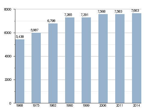
In 2014, about 7,663 people lived in Céret. This means there were about 202 people living in each square kilometer.
How Céret's Population Grew
Evolution of the population in Céret
How Céret is Governed
Céret has been an important administrative center since 1790. It's the main town for the arrondissement of Céret. It's also the central town for a larger area called the canton Vallespir-Albères, which includes 13 different towns and had almost 30,000 people in 2014.
The town is part of a group of communities called Vallespir (French: Communauté de communes du Vallespir), which work together on local projects.
Who are the Mayors?
Here are some of the people who have served as mayor of Céret:
| Mayor | Term start | Term end |
|---|---|---|
| Onuphre Tarris | 1919 | 1940 |
| Henri Rey | 1940 | 1941 |
| Henri Mouchard | 1941 | 1943 |
| Jean Maler | 1943 | 1944 |
| Jacques Souquet | 1944 | 1945 |
| Gaston Cardonne | 1945 | 1947 |
| Henri Guitard | 1947 | 1963 |
| Marcel Parayre | 1963 | 1964 |
| Michel Sageloly Sr. | 1964 | 1983 |
| Henri Sicre | 1983 | 1995 |
| Michel Sageloly Jr. | 1995 | 1996 |
| Henri Sicre | 1996 | 2001 |
| Alain Torrent | 2001 | 2020 |
| Michel Coste | 2020 |
Sister Cities
Céret has special friendships with other towns around the world. These are called "twin towns" or "sister cities":
What Céret is Known For
The area around Céret is famous for growing lots of fruit, especially delicious cherries. It's a tradition that the very first cherries picked each season are sent to the President of France! Céret even has a cherry festival every year, usually in late April and May.
Cool Places to Visit
Céret is well-known for its Museum of Modern Art. This museum has many amazing paintings, sculptures, and ceramics by famous artists like Picasso, Chagall, and Matisse. You can also see works by artists from the Fauves and Impressionists art movements.
The Museum of Musical Instruments opened in 2013. It has a special collection of musical instruments and old musical scores.
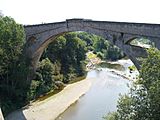
Don't miss the Pont du Diable, which means "Devil's Bridge." This old stone bridge has a single arch and was built a very long time ago, between 1321 and 1341.
Gallery
Related Pages
Images for kids
See also
 In Spanish: Céret para niños
 | Aaron Henry |
 | T. R. M. Howard |
 | Jesse Jackson |


