Thangool facts for kids
Quick facts for kids ThangoolQueensland |
|||||||||||||||
|---|---|---|---|---|---|---|---|---|---|---|---|---|---|---|---|
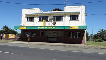
Hotel Thangool, 2014
|
|||||||||||||||
| Population | 685 (2021 census) | ||||||||||||||
| • Density | 0.9804/km2 (2.539/sq mi) | ||||||||||||||
| Established | 1925 | ||||||||||||||
| Postcode(s) | 4716 | ||||||||||||||
| Elevation | 192 m (630 ft) | ||||||||||||||
| Area | 698.7 km2 (269.8 sq mi) | ||||||||||||||
| Time zone | AEST (UTC+10:00) | ||||||||||||||
| Location |
|
||||||||||||||
| LGA(s) | Shire of Banana | ||||||||||||||
| State electorate(s) | Callide | ||||||||||||||
| Federal Division(s) | Capricornia | ||||||||||||||
|
|||||||||||||||
|
|||||||||||||||
Thangool is a small town and area in the Shire of Banana, Queensland, Australia. It's a rural place, meaning it's mostly countryside with farms. In 2021, about 685 people lived in Thangool.
Contents
Exploring Thangool's Location
Thangool is about 591 kilometers (367 miles) north-west of Brisbane, the capital city of Queensland. It's also just 12 kilometers (7.5 miles) south of Biloela, which is the main town for the Shire of Banana.
Inside the Thangool area, there are smaller parts called neighbourhoods. These include Kariboe and Mount Scoria.
Thangool is also home to some mountain ranges:
- Banana Range in the south-west.
- Dawes Range in the south-east.
You can find several mountains here too:
- Mount Lookerbie, which is 530 meters (1,739 feet) high.
- Mount Scoria, at 292 meters (958 feet).
- Mount Sugarloaf, standing 484 meters (1,588 feet) tall.
- Prospect Peak, reaching 449 meters (1,473 feet).
A railway line, called the Callide Valley railway line, used to run through Thangool. It had three stations: Thangool, Kariboe, and Mount Scoria. These stations are no longer used.
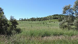
Most of the land in Thangool is used for grazing animals like cattle. There's also some farming where crops are grown.
| Climate data for Thangool Airport (1991–2020 normals, extremes 1965–present) | |||||||||||||
|---|---|---|---|---|---|---|---|---|---|---|---|---|---|
| Month | Jan | Feb | Mar | Apr | May | Jun | Jul | Aug | Sep | Oct | Nov | Dec | Year |
| Record high °C (°F) | 43.1 (109.6) |
42.2 (108.0) |
42.4 (108.3) |
36.1 (97.0) |
35.0 (95.0) |
30.2 (86.4) |
30.1 (86.2) |
34.5 (94.1) |
38.7 (101.7) |
40.0 (104.0) |
40.4 (104.7) |
41.4 (106.5) |
43.1 (109.6) |
| Mean daily maximum °C (°F) | 33.8 (92.8) |
33.0 (91.4) |
32.0 (89.6) |
29.6 (85.3) |
26.2 (79.2) |
23.5 (74.3) |
23.3 (73.9) |
25.0 (77.0) |
28.2 (82.8) |
30.5 (86.9) |
32.0 (89.6) |
33.2 (91.8) |
29.2 (84.6) |
| Daily mean °C (°F) | 26.8 (80.2) |
26.4 (79.5) |
25.0 (77.0) |
21.9 (71.4) |
18.1 (64.6) |
15.4 (59.7) |
14.5 (58.1) |
15.7 (60.3) |
19.0 (66.2) |
22.0 (71.6) |
24.2 (75.6) |
25.9 (78.6) |
21.3 (70.3) |
| Mean daily minimum °C (°F) | 19.8 (67.6) |
19.8 (67.6) |
18.0 (64.4) |
14.1 (57.4) |
10.0 (50.0) |
7.3 (45.1) |
5.7 (42.3) |
6.3 (43.3) |
9.9 (49.8) |
13.5 (56.3) |
16.3 (61.3) |
18.7 (65.7) |
13.3 (55.9) |
| Record low °C (°F) | 12.3 (54.1) |
12.3 (54.1) |
9.2 (48.6) |
0.8 (33.4) |
−1.4 (29.5) |
−3.4 (25.9) |
−4.7 (23.5) |
−3.3 (26.1) |
−0.7 (30.7) |
2.6 (36.7) |
4.9 (40.8) |
8.7 (47.7) |
−4.7 (23.5) |
| Average precipitation mm (inches) | 92.7 (3.65) |
90.5 (3.56) |
65.1 (2.56) |
21.7 (0.85) |
24.4 (0.96) |
29.4 (1.16) |
17.7 (0.70) |
22.9 (0.90) |
28.0 (1.10) |
54.2 (2.13) |
71.9 (2.83) |
96.7 (3.81) |
615.3 (24.22) |
| Average precipitation days (≥ 1 mm) | 6.1 | 6.0 | 4.3 | 2.9 | 2.4 | 3.1 | 2.5 | 2.2 | 2.7 | 5.2 | 5.5 | 6.1 | 48.9 |
| Average dew point °C (°F) | 18.2 (64.8) |
18.6 (65.5) |
17.2 (63.0) |
14.0 (57.2) |
10.5 (50.9) |
8.7 (47.7) |
7.0 (44.6) |
6.9 (44.4) |
9.3 (48.7) |
12.3 (54.1) |
14.9 (58.8) |
17.1 (62.8) |
12.9 (55.2) |
| Source 1: National Oceanic and Atmospheric Administration | |||||||||||||
| Source 2: Bureau of Meteorology | |||||||||||||
A Look Back at Thangool's History
The land where Thangool is now was originally home to the Kangulu Aboriginal people. Later, in the 1850s, European settlers started to arrive. They first tried to raise sheep, but soon switched to cattle.
The name Thangool comes from the old Thangool railway station. It's believed to be an Aboriginal word meaning possum. The neighbourhood Mount Scoria is named after the mountain, and Kariboe is named after a local creek. Kariboe is also an Aboriginal word.
The town of Thangool was officially planned in 1925. Soon after, simple shops were built. The railway line reached Thangool in 1925, helping the town grow.
Several schools opened and closed in the area over the years:
- Kariboe Creek Provisional School (1926-1927) and Kariboe Creek State School (1930-1963).
- Thangool State School opened on April 5, 1927, and is still open today.
- Mount Scoria State School (1930-1958).
- Thangool Baptist Church opened in 1932.
- Kroombit Provisional School (1933-1936).
- Tiamby Provisional School (1933-1942).
- Clinker Creek State School (1938-1942).
By the 1930s, Thangool was doing well because of a "cotton boom." This meant there were many businesses, including two hotels, two butchers, two bakers, a movie theater, and a bank. One of the hotels, the Red Steer Hotel, closed in 2017. Now, the Thangool Recreation Club has a special license so locals can still gather for a drink.
Who Lives in Thangool?
In 2021, the Thangool area had a population of 685 people. In 2016, it was 741 people, and in 2006, it was 545 people.
Learning in Thangool
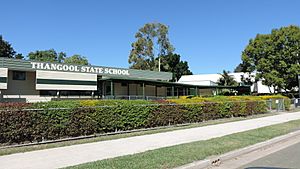
Thangool State School is the local primary school for students from Prep to Year 6. It's for both boys and girls and is located at 2 Aerodrome Road. In 2018, the school had 143 students.
There are no high schools in Thangool. Students usually go to Biloela State High School in Biloela, which is nearby.
Thangool's Economy
Farmers in Thangool grow various crops. Without irrigation (dryland farming), they mainly grow sorghum and wheat. They also grow some sunflower, mung beans, and barley. With irrigation, they grow cotton, lucerne, wheat, and sorghum.
A business in Thangool, Queensland Squab Processors, provides a large amount of squab (young pigeons used for food) to the Australian market. Another new business grows herbs for restaurants and food services.
You'll also find several homesteads (large farmhouses) in the area, such as Kurrajong, Peaceful Haven, and Scoria.
Places and Services in Thangool
Thangool has several local businesses and services:
- There's the Hotel Thangool at 49-55 Ramsay Street.
- You can find a service station, a post office, carpenters, and welders.
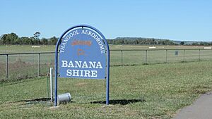
- The Thangool Airport (also called Thangool Aerodrome) serves the whole Banana Shire area. It's located at 42 Aerodrome Road.
- Thangool also has a large racecourse where horse races are held.
- The Thangool Fire Station is at 25 Stanley Street.
Community Life and Amenities
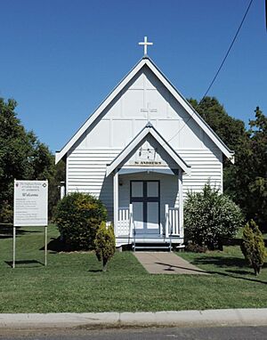
- St Andrew's Anglican Church is at 35 Stanley Street.
- The Thangool Recreational Hall is on Blanchs Road. This is where the Thangool branch of the Queensland Country Women's Association meets.
Things to See and Do
Nearby Mount Scoria is a very interesting natural attraction. It's a rare rock formation that rises 150 meters (492 feet) above the flat land around it. This mountain was an active volcano millions of years ago! It has amazing basalt columns, which are like tall, many-sided pillars formed when lava cools down.
Events in Thangool
Thangool hosts a few fun events each year:
- The Thangool Cup Races is an annual horse racing event held in September.
- Every November, there's a Christmas market where you can find gifts and festive items.
 | Selma Burke |
 | Pauline Powell Burns |
 | Frederick J. Brown |
 | Robert Blackburn |


