The Cook Inlet Basin facts for kids
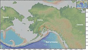
The Cook Inlet Basin is a large area in south-central Alaska, stretching from the Gulf of Alaska towards the Matanuska Valley. It sits between a big rock formation called a batholith and a deep ocean trench. This basin is filled with about 80,000 cubic miles of sedimentary rocks, which are rocks formed from layers of sediment. These sediments mostly came from older rocks from the Triassic, Jurassic, and Cretaceous periods.
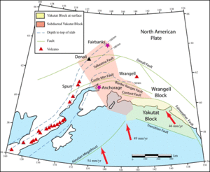
Two major geological forces are very active here. On the western side, the basin is right above the Aleutian subduction zone. This is where the Pacific Plate is slowly sliding underneath the North American Plate. On the eastern side, another smaller plate, the Yakutat microplate, is also sliding under the North American Plate. These movements cause a lot of squeezing and pressure, which leads to the bending and breaking of rocks, forming structures called anticlines. These anticlines are perfect places where oil and natural gas can get trapped, making the Cook Inlet Basin famous for its oil and gas production.
Contents
How Alaska's Geology Was Formed
The land of Alaska has changed a lot over the last 100 million years. Its features were shaped by huge pieces of the Earth's crust, called plates, crashing into each other and sliding beneath one another. This process is known as plate convergence and subduction.
The Pacific Plate's Big Push
Most of Alaska's geology is controlled by the Pacific Plate sliding beneath the North American Plate. This boundary is a 4,000 km long ditch in the ocean floor called the Aleutian Trench. Earthquakes are common here, and the volcanoes formed are part of the Pacific Ring of Fire.
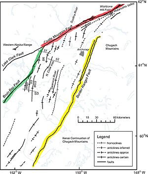
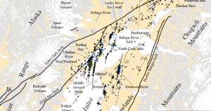
When the Pacific Plate first started to slide down, it created the Bruin Bay Fault system. This system caused many faults, or cracks in the Earth's crust, to form in the western part of the Cook Inlet Basin. The squeezing along this active boundary makes the rock layers bend into anticline shapes.
The Yakutat Microplate's Collision
The Yakutat microplate is a smaller piece of the Earth's crust that crashed into Alaska sometime during the Miocene epoch. This happened after the Pacific Plate had already started to slide underneath. The Yakutat microplate has a base of ocean crust covered by continental crust.
This ongoing collision is causing the land in front of the mountains to fold and collapse, like a zipper closing up. This collision also builds up a large pile of rock and sediment called an accretionary prism. This prism forms the Kenai Mountains, which are next to the southeast part of the Cook Inlet basin.
Looking Inside the Earth
Geologists use cross-sections to show what the layers of rock look like deep underground. This helps them understand how the basin formed and where oil and gas might be found.
Major Fault Lines
Faults are large cracks in the Earth's crust where rocks have moved past each other.
Bruin Bay Fault System
The Bruin Bay fault system is a group of faults that run for about 498 km along the western side of the basin. They start south of Becharof Lake on the Alaskan Peninsula and end near the Castle Mountain Lake fault system.
These faults separate older volcanic rocks from younger marine and non-marine rock layers. The faults usually dip steeply to the west. Over time, many layers of sediment have covered them, so they are mostly found deep underground. Scientists believe these faults were active a long time ago, even before the Oligocene epoch.
Border Ranges Fault System
The Border Ranges Fault system is a very long fault, stretching 1,500 mi on the eastern side of the basin. It separates the main basin from the area where the plates are sliding under each other. This fault system formed a long time ago because of the huge plate subduction. It was later filled with sediment deposits. Since then, it has been squeezed and deformed by sideways movements of the Earth's crust.
Castle Mountain Fault System
This fault system is about 200 km long and runs northeast. It is special because it's the only fault in the area that shows recent movement at the surface. Movement along this fault dates back as far as 47 million years ago. It was likely active during the Jurassic Period and is still partly active today.
Layers of Rock (Stratigraphy)
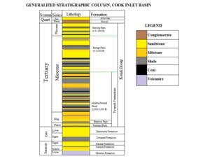
The Cook Inlet Basin is made up of many different layers of rock, each telling a story about the Earth's past. Here are some of the main formations:
- Tuxendi Formation
- This layer is mostly made of fine-grained rock called siltstone, which has a lot of clay and some plant material.
- Hemlock Formation
- This formation contains sandstone and conglomerate sandstone, which are rocks made of sand and pebbles cemented together.
- Tyonek Formation
- This layer has thick beds of sandstone mixed with siltstone and thin layers of coal.
- West Foreland Formation
- This formation is made of conglomerates, sandstone, and siltstone.
- Sterling Formation
- This layer generally has many stacked river channels, with thick sandstone and conglomerate mixed with mudstones, siltstones, and thin coal layers.
- Beluga Formation
- This formation consists of siltstone with river sandstone, thin layers of coal that don't stretch very far, and volcanic ash layers.
How Sediments Were Laid Down
Late Triassic and Early Jurassic (237 Ma–174 Ma)
The rocks from the Late Triassic (Kamishak Formation) and Early Jurassic (Talkeetna Formation) were part of an oceanic island arc. These formations are found along the Bruin Bay Fault zone. They have been pushed into by hot, molten rock from deep inside the Earth. This molten rock came from the Pacific Plate sliding under the North American Plate.
The Kamishak Formation shows that the area was once a shallow reef that gradually became deeper ocean. During the Late Triassic, the Pacific Plate's movement caused molten rock to push into the existing rocks, especially near the Bruin Bay Fault zone.
The Jurassic Talkeetna formation sits on top of the Kamishak formation, though there are some gaps in the rock layers. The Talkeetna is mostly made of volcanic material, like lava flows and volcanic ash. Studies of the lava flows suggest this formation was once very deep in the ocean.
Middle and Upper Jurassic (174 Ma–145 Ma)
During the middle to late Jurassic, a huge mass of combined sediments crashed into the coast of Alaska. This collision caused the shallow crust to be lifted up and worn away, exposing the volcanic rock intrusions. The rock layers from this time show marine sandstones, shales, and limestones that formed during mountain building. There are three main breaks in the rock layers: the lower Tuxendi Group, the upper Tuxedni Group, and the Naknek Formation.
The Lower Tuxendi Group
The Lower Tuxendi Group is made of deep-water marine sediments. These layers show two times when the ocean level rose and fell. Between these periods, the sediments show an environment like a river delta.
Upper Tuxedni Group
The Upper Tuxendi Group is similar to the lower group, showing a marine environment with river delta features. It also has layers of shale, siltstone, sandstone, and conglomerates. However, this marine pattern isn't seen throughout the entire group. There are also non-marine debris flows that eventually turn into sandy marine deposits, showing a high-energy ocean environment.
Naknek Formation
The Naknek Formation is a very thick layer of rock, up to 10,000 ft, but its thickness changes across the Alaskan Peninsula. The rocks in this formation show dramatic changes, from large sediments (like cobbles and boulders) to sandstones with many fossils.
Tertiary (65 Ma–2 Ma)
West Foreland Formation
The rocks in the West Foreland Formation mostly came from older eroded rocks. They were carried by streams and currents into a shallow estuary environment. This formation also has layers of siltstone, sandstone, conglomerates, and coal beds.
Hemlock Formation
The Hemlock Formation is about 600 feet thick and is mostly made of conglomerate deposits, which suggests it formed in a river-delta environment. This is a very important oil-producing layer and has produced over 315 million barrels of oil!
Sterling Formation
The Sterling Formation has about 10,000 ft of thick sandstone. It was deposited in the central and eastern parts of the Cook Inlet Basin during the late Tertiary-early Quaternary period. During this time, the land was rising, and a lot of sediment came from the Chugach range and the Alaskan Range. The lower Sterling sandstones are major natural gas reservoirs and have produced over 330 billion cubic feet of gas.
Beluga Formation
The Beluga Formation has alternating layers of sand, silt, and coal, followed by thick sandstone deposits. The sand mostly came from river channels to the North. However, the uplift and erosion of the Chugach range provided the conglomerate sediments to the basin. Over 56 billion cubic feet of gas has been produced here.
Oil and Gas Production
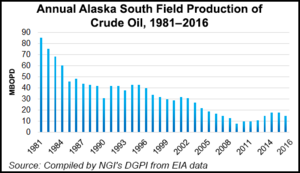
The Cook Inlet Basin is a big area for finding hydrocarbons (oil and natural gas). Oil was first discovered here in the 1950s. The area where oil and gas are found stretches from Kachemak Bay north to the mouth of the Susitna River, covering almost 5,000 square miles.
Middle Ground Shoal (MGS) Oil Field
The Middle Ground Shoal (MGS) oil field was found in the upper Cook Inlet in July 1962. It is considered one of the largest and most tightly folded anticlines in the Cook Inlet Basin. This field mainly produces oil from the Tertiary Tyonek Formation, which is part of the Kenai Group. The oil comes from a thick section of rock, about 2,800 ft, at depths between 5,100 and 9,700 ft.
As of 1974, the MGS field had produced almost 80 million barrels of oil.


