The Lakes, Minnesota facts for kids
Quick facts for kids
The Lakes
|
|
|---|---|

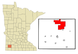
Location within Murray County and the state of Minnesota
|
|
| Country | United States |
| State | Minnesota |
| County | Murray |
| Townships | Lake Sarah Shetek Mason Murray |
| Area | |
| • Total | 43.45 sq mi (112.55 km2) |
| • Land | 33.70 sq mi (87.28 km2) |
| • Water | 9.76 sq mi (25.27 km2) |
| Elevation | 1,483 ft (452 m) |
| Population
(2020)
|
|
| • Total | 590 |
| • Density | 17.51/sq mi (6.76/km2) |
| Time zone | UTC-6 (Central (CST)) |
| • Summer (DST) | UTC-5 (CDT) |
| ZIP Codes | |
| FIPS code | 27-64543 |
| GNIS feature ID | 2393255 |
The Lakes is a special kind of community in Murray County, Minnesota. It is called an unincorporated community and a census-designated place (CDP). This means it's a recognized area for counting people, but it doesn't have its own city government.
The Lakes is located north of Currie and south of Garvin. In 2020, about 590 people lived here. The community is built around Lake Shetek, which is the biggest lake in southwestern Minnesota. The lake and the community are spread across four different townships: Lake Sarah, Shetek, Murray, and Mason.
Exploring the Geography of The Lakes
The Lakes community is in the northern part of Murray County. It reaches all the way up to the border of Lyon County. This area includes Lake Shetek, along with Lake Sarah and Lake Maria to the west. You'll also find several smaller lakes near Lake Shetek.
The total area of The Lakes is about 43.4 square miles (112.5 square kilometers). Most of this area, about 33.7 square miles (87.3 square kilometers), is land. The rest, about 9.8 square miles (25.3 square kilometers), is water. This means water makes up about 22% of the total area. The Des Moines River starts at the southern end of Lake Shetek and flows south towards Iowa.
The small community of Owanka is located on the eastern side of Lake Shetek. You can also find Lake Shetek State Park on the southeast side of the lake.
Two important roads pass through The Lakes. U.S. Highway 59 runs through the western part of the community. It goes south about 10 miles (16 km) to Slayton, which is the main town in Murray County. Northward, it goes about 23 miles (37 km) to Marshall. Minnesota State Highway 30 runs along the southern edge of The Lakes. This highway leads east towards Currie and Dovray.
Population and Community Life
| Historical population | |||
|---|---|---|---|
| Census | Pop. | %± | |
| 2000 | 619 | — | |
| 2010 | 667 | 7.8% | |
| 2020 | 590 | −11.5% | |
| U.S. Decennial Census | |||
The population of The Lakes changes over time. In 2000, there were 619 people living here. By 2010, the population grew to 667 people. However, in the 2020 census, the population was 590 people.
In 2000, there were 267 households in The Lakes. A household is a group of people living together in one home. Most households were made up of married couples. About 19% of households had children under 18 living with them. The average household had about 2.3 people.
The people living in The Lakes are of different ages. In 2000, about 16.6% of the population was under 18 years old. About 15.5% of the people were 65 years old or older. The median age was 49 years, meaning half the people were younger than 49 and half were older.
See also
 In Spanish: The Lakes (Minnesota) para niños
 | Emma Amos |
 | Edward Mitchell Bannister |
 | Larry D. Alexander |
 | Ernie Barnes |

