The Meadows, Nottingham facts for kids
Quick facts for kids The Meadows |
|
|---|---|
| OS grid reference | SK 57384 38554 |
| District | |
| Shire county | |
| Region | |
| Country | England |
| Sovereign state | United Kingdom |
| Post town | NOTTINGHAM |
| Postcode district | NG2 |
| Dialling code | 0115 |
| Police | Nottinghamshire |
| Fire | Nottinghamshire |
| Ambulance | East Midlands |
| EU Parliament | East Midlands |
| UK Parliament |
|
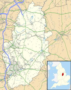
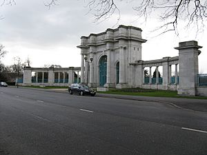
The Meadows is a lively area in Nottingham, England. It's located just south of the city centre, very close to the River Trent. You can easily reach West Bridgford from here using Trent Bridge or the Wilford Suspension Bridge. Along the River Trent, you'll find the Victoria Embankment, which is home to the beautiful Nottingham War Memorial Gardens.
The Meadows has two main parts:
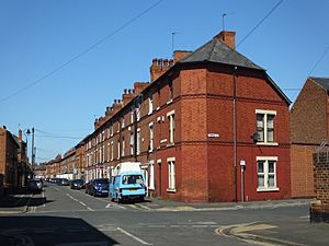
- The Old Meadows: This area has many older, privately owned houses built before 1919. They are set out in a traditional street pattern.
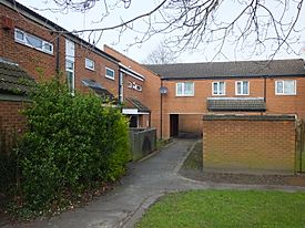
- The New Meadows: This part mostly has social housing (rented homes). It was built in the 1970s after older, less safe homes were removed. It used a special design called a Radburn Layout, which separated cars from people. Later, around 2008, this area was changed to have a more traditional street layout again. Some unpopular apartment blocks were even taken down.
The Meadows is easy to get around! It has two tram lines and two bus routes, with many more buses passing nearby. It's also just a short walk to Nottingham railway station. The Bridgeway shopping centre is a main meeting spot for the community, but its future is currently being discussed.
Contents
Exploring The Meadows' Location
The Meadows is an area in Nottingham, south of the castle and the city centre. It's part of the "Meadows ward" (which used to be called Bridge Ward).
Long ago, The Meadows was a big area of wet land or floodplain near the River Leen and the River Trent. Over time, this land was drained and developed. People built houses, pubs, factories, and public buildings like libraries and swimming pools here.
The area has clear boundaries:
- To the north: The low sandstone hill of Nottingham City Centre.
- To the south, southwest, and east: The winding River Trent.
- To the north and west: The Beeston and Nottingham Canal.
It's also separated from the rest of Nottingham by major roads like the A60 London Road and the A453 Queens Drive. A local road called Meadows Way runs alongside these main roads.
A Look Back at The Meadows' History
Many of the older terraced houses in The Meadows were built for people who worked on the railways and in factories. Some of these homes were even built by the railway company itself! Old photos show that The Meadows used to be a very busy community with many beautiful buildings.
In 1901, the Victoria Embankment opened. This was a long flood defence system with a walkway and road along the River Trent. It also included the New Meadows recreation ground. In 1906, a cricket pavilion and new football pitches were opened.
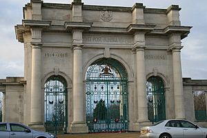
In 1920, a kind man named Jesse Boot bought more land along the Embankment and gave it to the people of Nottingham. He wanted it to be used forever for fun and as a memorial. This gift included the memorial gardens, playing fields, a war memorial, and sports pavilions, all of which are still there today.
The 'New Meadows' Project in the 1970s
In the 1970s, the local council decided that many homes in The Meadows were not suitable anymore. A large part of the area was taken down to build new, modern council houses. This new design was based on the Radburn model. This meant separating cars and people by building dead-end streets (cul-de-sacs), feeder roads, and underpasses.
In 1975, a large railway bridge and station were also taken down as the new development began. Today, there's no sign of the old Great Central Railway in The Meadows.
However, the Radburn model caused some problems. The council later said that the layout of the New Meadows contributed to anti-social behaviour and crime in the area.
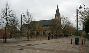
St Saviour's Church, built in 1864, is one of the few large buildings that survived the changes in the 1970s. The 'Old Meadows' area, with its traditional streets, also remains as a reminder of what the area used to look like.
Changes and Rebuilding After 2009
In 2009, Nottingham City Council asked experts to look at the problems in The Meadows. They wanted to get funding to improve the area. They were given £200 million, but this money was later taken away by the government.
Even without the big funding, the council worked with residents to create the Meadows Neighbourhood Plan. This plan aimed to redesign the New Meadows area. The idea was to bring back traditional street layouts instead of the confusing alleyways and underpasses from the 1970s. The council hoped this would make the area safer and easier for police to access.
The plans also included building a new shopping centre. The old Bridgeway Centre was to be taken down, and a new one built along a recreated 'Arkwright Street'. To create the traditional street look, many houses were planned to be "turned around," and some old apartment blocks ("Q" blocks) were to be replaced with new, energy-efficient family homes.
Even though the large grant was cancelled, the city council continued with smaller projects. Funding for tram line extensions and the railway station came from other sources.
In 2011, Nottingham City Homes (NCH) announced that many of the "Q" blocks, which were four-storey apartments, would be taken down. These blocks were not popular with residents or the police. This project was finished in 2016. It involved removing houses to bring back Arkwright Street as a main road for buses and local traffic, connecting Nottingham Station and Trent Bridge.
NCH also planned to build new family homes to replace the demolished properties. Two underpasses in The Meadows were removed and replaced with pedestrian crossings. The Bridgeway Shopping Centre stayed open, but it has fewer shops now.
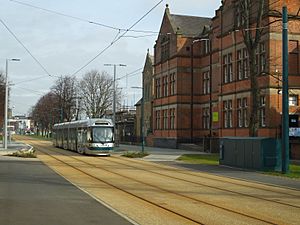
In early 2012, a new tram route to Clifton was built through Queens Walk. Most of the old trees along Queens Walk were kept, but about 40 trees were removed for the tram line.
Victoria Embankment and Memorial Gardens
The Victoria Embankment and the Memorial Gardens are located along a bend in the River Trent. In the 1800s, this land was often flooded. In 1897, some land was given to Nottingham Corporation to build flood defences. The Victoria Embankment was built between 1898 and 1901. It included concrete steps and an earth bank with a public road on top. A public recreation ground was also created by levelling the land. The New Meadows Recreation ground opened in May 1906.
In 1920, Sir Jesse Boot bought more land next to the river and gave it to the people of Nottingham. He wanted this "New Park" to always remain an open space for everyone to enjoy. This land now includes the Memorial Gardens, which honour those who died in World War I. The gardens were designed with a special cross-shaped pond, and a statue of Queen Victoria. There's also a beautiful Art Deco bandstand. In 2022, the memorial garden was significantly updated.
Population and Community
As of 2003, about 7,870 people live in The Meadows. The area has a diverse population, with a higher proportion of people from Mixed, Asian, and Black backgrounds compared to the national average.
Many young adults (aged 18-24) live here, more than the national average. Some reports have shown that many children in The Meadows are affected by poverty, and a high number of children receive free school meals. The area also has lower-than-average educational achievements, with fewer students getting good GCSE grades compared to the rest of Nottingham and the country. Many adults in the area do not have formal qualifications, which can lead to higher unemployment rates.
Local Government
The Meadows is part of "The Meadows" Ward within Nottingham City Council. As of May 2023, it is represented by two Labour Party Councillors: Councillor Eunice Regan and Councillor Michael Edwards. These councillors help make decisions for the local community.
Getting Around: Transport in The Meadows
Old Rail Services
The Great Central Railway used to run through The Meadows, connecting Nottingham to London. It even had a station in The Meadows called Nottingham Arkwright Street. However, due to a report in 1963 that looked at how cost-effective railway lines were, this line and station were closed permanently in 1969. Today, the tram system uses a bridge that replaced the old railway bridge over Nottingham Station.
Tram Services
The Meadows is well-served by the Nottingham Express Transit (NET) tram system, which started operating its second phase in August 2015. Both Line 1 (to Beeston and Chilwell) and Line 2 (to Wilford and Clifton) pass through The Meadows.
The tram stops located directly within The Meadows are:
- Meadows Way West (Line 1)
- Queens Walk (Line 2)
- Meadows Embankment (Line 2)
The NG2 (Line 1) and Nottingham Station (Lines 1 and 2) tram stops are also very close by.
Bus Services
The Meadows is also served by many bus routes, making it easy to travel around Nottingham and beyond.
- Meadows Way East and Victoria Embankments:
* Nottingham City Transport: 1, 1A, 1B, 1E, 3, 3A, 4, 5, 6, 7, 8, 9, 10, 10C, 10X, N4 * Trentbarton: The Cotgrave, The Keyworth, Mainline, Rushcliffe Villager. * Other services: 9 (Kinchbus), 90 (Vectare)
- Bridgeway Centre, Wilford Grove and Bathley Street:
* Nottingham City Transport: 11, 11A, 11C
- Bridgeway Centre and Robin Hood Way:
* Nottingham City Transport: 48, 48X
- Queens Drive:
* Nottingham City Transport: 49, 49A, 49B, 49X
 | Chris Smalls |
 | Fred Hampton |
 | Ralph Abernathy |


