
Tiffany Mountain facts for kids
Quick facts for kids Tiffany Mountain |
|
|---|---|
.jpg)
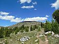
Tiffany Mountain seen from Honeymoon Pass
|
|
| Highest point | |
| Elevation | 8,245 ft (2,513 m) |
| Prominence | 2,766 ft (843 m) |
| Isolation | 18 mi (29 km) |
| Parent peak | Windy Peak (8,333 ft) |
| Listing | List of Highest Mountain Peaks in Washington |
| Geography | |

Tiffany Mountain
Location in Washington (state)

Tiffany Mountain
Location in the United States
|
|
| Location | Okanogan County Washington, U.S. |
| Parent range | Okanogan Range North Cascades Cascade Range |
| Topo map | USGS Tiffany Mountain |
| Climbing | |
| Easiest route | Hiking trail |
Tiffany Mountain is a tall mountain in Okanogan County, Washington state. It stands about 8,245-foot (2,513-metre) high. This mountain is the highest point in the Tiffany Range. The Tiffany Range is a smaller part of the larger Okanogan Range.
Tiffany Mountain is located on the eastern side of the Cascade Mountains. It is part of the land managed by the Okanogan National Forest. The closest mountain that is even taller is Windy Peak, which is about 18 miles (29 km) to the north. All the water from rain and melting snow on Tiffany Mountain flows into rivers that eventually join the Columbia River.
Contents
Why is it called Tiffany Mountain?
This mountain is named after a man named Will Tiffany (1863–1898). He used to have a camp at the bottom of the mountain. Will Tiffany was related to the famous Tiffany's jewelry company in New York. He was also a member of Roosevelt's Rough Riders. This was a group of soldiers who fought in the Spanish–American War in Cuba, where Will Tiffany sadly lost his life.
What is the climate like at Tiffany Mountain?
Most of the weather systems that affect Tiffany Mountain start over the Pacific Ocean. They usually travel northeast towards the Cascade Mountains.
How mountains affect the weather
When these weather systems reach the North Cascades, the tall peaks of the Cascade Range force the air upwards. As the air rises, it cools down and drops its moisture. This moisture falls as rain or snow onto the mountains. This process is called Orographic lift.
Because of this, the western side of the North Cascades gets a lot more rain and snow than the eastern side. This is especially true during the winter months.
Seasonal weather patterns
In winter, the weather is often cloudy. However, during the summer, strong high-pressure systems form over the Pacific Ocean. These systems often bring clear skies and very little cloud cover to the area.
How Tiffany Mountain was formed: Geology
The North Cascades region, where Tiffany Mountain is located, has very rugged land. It features sharp peaks, tall spires, long ridges, and deep valleys carved by glaciers. These different landforms and big changes in height were created by geological events over millions of years. These events also led to different climates in various parts of the Cascade Range.
The ancient history of the Cascade Mountains
The Cascade Mountains began to form millions of years ago, during a time called the late Eocene Epoch. At that time, the North American Plate was slowly moving over the Pacific Plate. This movement caused many volcanic eruptions and created igneous rocks.
Also, small pieces of the Earth's crust, called terranes, came together. These pieces were made of both oceanic and continental rock. They helped form the North Cascades about 50 million years ago.
The impact of glaciers and earth movements
Over two million years ago, during the Pleistocene period, glaciers repeatedly moved across the land. As they advanced and then melted back, they scraped away the landscape. They left behind piles of rock and debris. The river valleys in the area now have a "U" shape. This shape was created by these ancient glaciers.
The main processes that created the tall peaks and deep valleys of the North Cascades are uplift (when land is pushed up) and faulting (when parts of the Earth's crust slide past each other). These processes, combined with the action of glaciers, shaped the mountains we see today.
Images for kids
-
Tiffany Mountain's gentle south side

