
Windy Peak (Washington) facts for kids
Quick facts for kids Windy Peak |
|
|---|---|

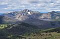
Windy Peak from Horseshoe Basin
|
|
| Highest point | |
| Elevation | 8,333 ft (2,540 m) |
| Prominence | 1,771 ft (540 m) |
| Listing | Washington major summits 36th |
| Geography | |

Windy Peak
Location in Washington (state)

Windy Peak
Location in the United States
|
|
| Location |
|
| Parent range | Okanogan Range North Cascades Cascade Range |
| Topo map | USGS Horseshoe Basin |
| Climbing | |
| Easiest route | Hiking via Windy Trail |
Windy Peak is a tall mountain in Okanogan County, Washington state. It stands at about 8,333 feet (2,540 meters) high. This peak is part of the Okanogan Range, which is a smaller part of the larger North Cascades and Cascade Range mountain systems.
The mountain is located about 5 miles (8 kilometers) south of the border between Canada and the United States. It sits on the eastern side of the main Cascade mountain ridge. Windy Peak is inside the Pasayten Wilderness, an area managed by the Okanogan National Forest. The closest higher mountain is Haystack Mountain, which is about 9.24 miles (14.87 kilometers) to the northwest in Canada. Water flowing from Windy Peak eventually reaches the Methow River and Similkameen River.
Contents
What is the Climate Like at Windy Peak?
Most weather systems begin over the Pacific Ocean. They then move northeast towards the Cascade Range. As these weather systems approach the North Cascades, the tall mountains force the air upwards. This process, called orographic lift, causes the air to cool and drop its moisture. This moisture falls as rain or snow onto the Cascades.
How Does Weather Affect the Cascades?
Because of this, the western side of the North Cascades gets more rain and snow than the eastern side. This is especially true during the winter months. In winter, the weather is often cloudy. However, during summer, high-pressure systems over the Pacific Ocean become stronger. This often leads to clear skies and little to no cloud cover.
How Did Windy Peak Form?
The North Cascades mountains have very rugged shapes. You can see sharp peaks, tall spires, long ridges, and deep valleys carved by glaciers. These different shapes and huge changes in height were created by geological events over millions of years. These events also led to the different climates found across the Cascade Range.
The Ancient History of the Cascades
The story of how the Cascade Mountains formed goes back millions of years. It started in the late Eocene Epoch. At that time, the North American Plate was slowly moving over the Pacific Plate. This movement caused many periods of volcanic activity. Also, small pieces of the Earth's outer layer, called terranes, came together. These pieces helped create the North Cascades about 50 million years ago.
How Glaciers Shaped the Mountains
During the Pleistocene period, which began over two million years ago, glaciers repeatedly moved across the land. As they advanced and then melted back, they scraped and shaped the landscape. They left behind piles of rock and debris. The "U"-shaped valleys you see today were formed by these recent glaciers. The combination of land being pushed upwards (called uplift) and cracks in the Earth's crust (called faulting), along with the action of glaciers, created the tall peaks and deep valleys of the North Cascades area.
Images for kids
-
Windy Peak from the north

