Tolmie Peak facts for kids
Quick facts for kids Tolmie Peak |
|
|---|---|

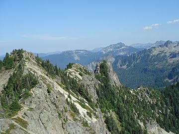
View along ridgeline from summit
|
|
| Highest point | |
| Elevation | 5,920+ ft (1,800+ m) NGVD 29 |
| Prominence | 760 ft (230 m) |
| Geography | |
| Location | Mount Rainier National Park, Pierce County, Washington, U.S. |
| Parent range | Cascade Range |
| Topo map | USGS Golden Lakes |
Tolmie Peak is a mountain that stands about 5,920 feet (1,804 meters) tall. It's located in the beautiful Mount Rainier National Park in Washington state, USA. This peak is part of the Cascade Range, a long chain of mountains. You can find it about 2 miles northwest of Mowich Lake, in the park's northwestern area.
Contents
Exploring Tolmie Peak
Tolmie Peak is a popular spot for hikers and nature lovers. From its summit, you can often see amazing views of the surrounding mountains and forests. The peak is known for its rugged beauty and the peaceful feeling of being high up in the wilderness.
Waterways Around the Peak
Many small streams flow down the sides of Tolmie Peak. These include Tolmie Creek and Ranger Creek. All these streams eventually join the Carbon River. The Carbon River then flows into the Puyallup River, which finally reaches the Puget Sound. This shows how all the water in this area is connected.
Just south of Tolmie Peak, you'll find a lovely place called Eunice Lake. This lake sits in a basin, which is like a bowl-shaped dip in the land. Glaciers, which are huge, slow-moving rivers of ice, carved out this basin a very long time ago. To the northwest of Tolmie Peak is another mountain called Howard Peak.
How Tolmie Peak Got Its Name
Tolmie Peak is named after a person named William Fraser Tolmie. He was an important figure in the early history of the Pacific Northwest.
Early Exploration
In August 1833, William Fraser Tolmie was working for the Hudson's Bay Company. This was a very old and famous company that traded furs. Tolmie was stationed at a new trading post called Fort Nisqually.
He decided to explore the area around Mount Rainier. This was one of the first recorded times someone explored this part of the mountains. Tolmie wanted to climb Mount Rainier itself, but it was too difficult. Instead, he and two Native American guides, Lachalet and Nuckalkat, climbed one of the snowy peaks nearby. This peak was close to where the Mowich River begins.
Even though Tolmie Peak is named after this event, we don't know for sure if it was the exact peak they climbed. But the name honors his important journey into the Mount Rainier wilderness.
 | Selma Burke |
 | Pauline Powell Burns |
 | Frederick J. Brown |
 | Robert Blackburn |

