Torc Mountain facts for kids
Quick facts for kids Torc Mountain |
|
|---|---|
| Sliabh Torc | |

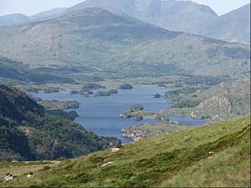
View from the summit of Torc Mountain looking westwards to the Upper Lake in the Black Valley
|
|
| Highest point | |
| Elevation | 535 m (1,755 ft) |
| Prominence | 300 m (980 ft) |
| Listing | Marilyn, Arderin |
| Naming | |
| English translation | mountain of wild boar |
| Language of name | Irish |
| Geography | |
| Location | Kerry, Ireland |
| Parent range | Mangerton Mountain Group |
| OSI/OSNI grid | V955839 |
| Topo map | OSi Discovery 78 |
| Geology | |
| Age of rock | Devonian |
| Mountain type | Green sandstone & purple siltstone, (Glenflesk Chloritic Sandstone Formation) |
| Climbing | |
| Easiest route | Old Kenmare Road |
Torc Mountain (which means "mountain of wild boar" in Irish) stands tall at 535 meters (1,755 feet). It's a well-known mountain in County Kerry, Ireland. Torc Mountain is part of the Mangerton Mountain Group. It's a favorite spot for hikers because of its easy-to-follow path. This path goes from the bottom, near Torc Waterfall, all the way to the top. From the summit, you can see amazing views of the Lakes of Killarney.
Contents
What's in a Name? The Story of Torc Mountain
The name "Torc" comes from the Irish word for "wild boar." This area has many old stories about wild boars. In ancient Celtic myths, wild boars were seen as symbols of strength and brave fighting skills.
Legends of the Wild Boar
One legend tells of a man cursed by the Devil. He turned into a wild boar every night. When a farmer found out his secret, the man burst into flames. He disappeared into a place called the Devil's Punchbowl on Mangerton Mountain. A river, the Owengarriff, then flowed out to hide the entrance to his cave. This cave was said to be hidden beneath the Torc Waterfall.
Another story is about the famous Irish warrior, Fionn mac Cumhaill. He was said to have killed a magical boar on Torc Mountain. He used his special golden spear to defeat it.
Where is Torc Mountain?
Torc Mountain is part of the Mangerton Mountain Group. This is a large group of mountains located south of Killarney. This mountain group has 26 other peaks that are taller than 100 meters (328 feet). Torc Mountain is located in the northwest part of this group. Just west of Torc Mountain is a smaller peak called Torc Mountain West Top, which is 470 meters (1,542 feet) high.
Mountain Classifications
Torc Mountain is tall enough to be listed on two important mountain lists. It is a "Marilyn" in the British Isles. It is also an "Arderin" in Ireland. These lists help people classify mountains based on their height and how much they stand out from the land around them.
Hiking Torc Mountain
Torc Mountain is a popular place for people who love to hike. You can start your walk from the Torc Waterfall. There's a path made of stone steps that leads up from the base.

The Path to the Summit
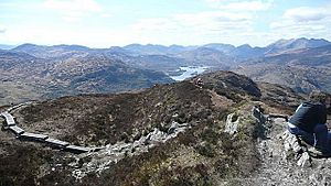
After the stone steps, the path turns into a small road. This road is called the Old Kenmare Road. It leads you closer to the mountain. The final part of the climb has a special path made of wooden railway "sleepers." These wooden planks help you walk easily over the boggy ground. Because of this well-made path, you don't need special hiking boots. You also don't need special maps or navigation skills.
Amazing Views from the Top
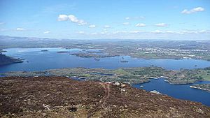
When you reach the top of Torc Mountain, you'll see incredible views. You can look down at the beautiful Lakes of Killarney. You'll also see the Black Valley, the tall peaks of the MacGillycuddy's Reeks, and the historic Muckross House and its gardens.
The walk from the Torc Waterfall car park to the summit and back is about 8 kilometers (5 miles) long. It usually takes about 3 hours to complete.
Shorter Routes
If you want a shorter hike, you can start from the upper Torc Waterfall car park. This car park is 55 meters (180 feet) higher up. From there, the route to the summit and back is about 7.5 kilometers (4.7 miles). This shorter walk takes about 2.5 hours. You follow the Old Kenmare Road for this route.
You can also get great views by climbing the steep stone steps of Cardiac Hill. This hill is halfway up the north side of Torc Mountain. You can reach it from the N71 Road, which is half a kilometer from the Torc Waterfall car park.
 | Georgia Louise Harris Brown |
 | Julian Abele |
 | Norma Merrick Sklarek |
 | William Sidney Pittman |


