Mangerton Mountain facts for kids
Quick facts for kids Mangerton(and Mangerton Mountain Group) |
|
|---|---|
| An Mhangarta | |
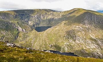
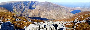
Mangerton (c) with the hanging lake of Lough Erhogh (c) and Mangerton North Top (r)
|
|
| Highest point | |
| Elevation | 838.2 m (2,750 ft) |
| Prominence | 583 m (1,913 ft) |
| Listing | Marilyn, Hewitt, Arderin, Simm, Vandeleur-Lynam |
| Naming | |
| English translation | long haired (mountain) |
| Language of name | Irish |
| Geography | |
| Location | County Kerry, Republic of Ireland |
| Parent range | Mangerton Mountain Group |
| OSI/OSNI grid | V980807 |
| Topo map | OSi Discovery 78 |
| Geology | |
| Age of rock | Devonian |
| Mountain type | Green sandstone & purple siltstone |
| Climbing | |
| Easiest route | Devil's Punchbowl |
Mangerton Mountain is a tall peak in Ireland, standing at about 838 meters (2,750 feet) high. It's one of the highest mountains in the country! It's also known as An Mhangarta in Irish, which means "the long-haired mountain."
Mangerton is the highest point in a group of mountains called the Mangerton Mountain Group. This group includes five other big mountains that are over 610 meters (2,000 feet) tall. Part of Mangerton is located within the beautiful Killarney National Park.
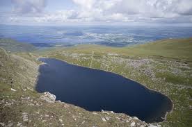
On the mountain's side, you'll find a deep, bowl-shaped lake called the Devil's Punchbowl. It's a popular spot for people who enjoy hiking. Even though it's a great place, some hikers might choose to visit Torc Mountain nearby because it's easier to reach. Long ago, in the 13th century, an important battle took place on the northern slopes of Mangerton. It was fought between Irish forces (the Mac Cárthaigh) and Norman forces (the FitzGeralds).
Contents
What's in a Name?
The name "Mangerton" likely comes from the Irish phrase An Mhangarta. This means "the long-haired mountain."
Some experts think the name might also come from an old Irish word, mangart, which means "movement" or "shaking." This could refer to the soft, boggy ground on the mountain's southern slopes that can sometimes move. Or, it could mean something that is "moving" or "fickle."
Exploring Mangerton's Geography
Mangerton's Peaks and Lakes
Mangerton has a wide, flat top that can be quite boggy. It also has smaller peaks nearby, like Mangerton North Top (782 meters) and Glencappul Top (700 meters). Another peak, Stoompa (705 meters), is part of Mangerton's horseshoe-shaped mountain range.
Deep, bowl-shaped hollows, called corries, are carved into the sides of Mangerton. These include the Horse's Glen (or Glencappul) and the famous Devil's Punchbowl. The southern parts of Mangerton form a huge, wild plateau. This area is home to herds of red deer and sika deer.
Three lakes flow from Mangerton's corries into the Horse's Glen. These are Lough Garagarry, Lough Mannagh, and Lough Erhogh. Lough Erhogh is a special "hanging" glacial lake, sitting high up in a corrie on the mountain's northeast side.
The Devil's Punchbowl (called Poll Ifrinn in Irish) is a deep, oval-shaped corrie lake. It's located at 670 meters (2,200 feet) on Mangerton's northwest side. Water from this lake flows into the Owengarriff River, which then forms Torc Waterfall. Finally, this water reaches the beautiful Lakes of Killarney below. The western slopes of Mangerton are part of the Killarney National Park.
Mangerton Mountain is tall enough to be listed in several important mountain categories in the British Isles. These include the Marilyn, Arderin, Simm, and Hewitt classifications. It's also ranked as the 10th-highest mountain in Ireland on the MountainViews Online Database's "100 Highest Irish Mountains" list.
The Mangerton Mountain Range
Around Mangerton, there are 25 other peaks that are over 100 meters (328 feet) tall. This whole area is known as the Mangerton Group or Mangerton Mountains.
The range is surrounded by roads, including the N71 to the north and west, the N22 to the east, and the R569 to the south. Some other notable mountains in this group are Dromderalough (650 meters), Dromderalough North-East Top (654 meters), Crohane (650 meters), and Knockbrack (610 meters). The popular tourist peak of Torc Mountain (535 meters) is also in the northwest part of this range.
Hiking on Mangerton
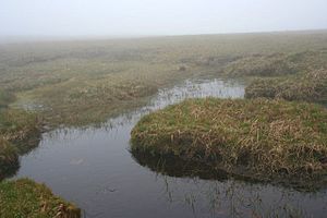
Mangerton's flat, boggy top sometimes means it's not as famous for hiking as other mountains. Especially when compared to the rocky peaks of the MacGillycuddy's Reeks. Even nearby Torc Mountain is sometimes suggested instead.
However, Mangerton is still a great place to hike! It offers amazing views and deep corries. Plus, it's close to Killarney town and easy to get to, which is a big plus for climbers.
The most direct way to reach Mangerton's summit is the Devil's Punchbowl Route. This hike takes about 4–5 hours and covers 10 kilometers (6 miles). You start at a bridge and follow a path south towards the Devil's Punchbowl lake. From there, you climb up the west side of the Punchbowl to reach Mangerton's flat top. Then, you walk about 300 meters across the top to the very highest point. You can return the same way or take a steeper path down the east side of the Punchbowl.
It's important to know that the top of Mangerton can be tricky to navigate if the weather is bad or foggy, as there aren't many clear landmarks.
You can also extend the Devil's Punchbowl Route to include the peak of Stoompa. This longer hike takes about 5–6 hours and covers 13.5 kilometers (8.4 miles). You can either go to Stoompa and back from Mangerton's summit, or do a "horseshoe" loop. This loop starts by going up the Devil's Punchbowl on the west side and finishes by coming down the northern slopes of Stoompa on the east side.
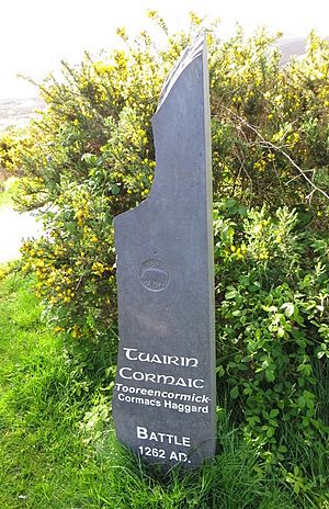
The Tooreencormick Battle Site
On the northern slopes of Mangerton, a significant battle took place in 1262. This fight was between the Mac Cárthaigh (Irish forces) and the FitzGeralds (Anglo-Norman forces). It happened after another big battle the year before.
The battle site is marked on maps and has a special stone monument. It's called Tooreencormick (Tuairín Cormaic in Irish), which means "little field of Cormac." This name comes from Cormac MacCarthy Reagh, an important Irish leader who was killed during the battle. Other brave knights also died there.
Even though both sides lost people, the battle is seen as a victory for the MacCarthy forces. It helped keep the Anglo-Normans out of South Kerry and West Cork for the next three centuries. This meant that the Irish way of life continued in that region for a long time.
Peaks of the Mangerton Mountain Group
The MountainViews Online Database lists 26 peaks in the Mangerton Mountain Group that are more than 100 meters (328 feet) tall.
Marilyn: Any height, and prominence over 150 metres (492 ft)
10||22
| Height rank |
Prom. rank |
Name | Irish name (if different) |
Translation | Height (m) |
Prom. (m) |
Height (ft) |
Prom. (ft) |
Topo. map |
OSI Grid Reference |
|---|---|---|---|---|---|---|---|---|---|---|
| 1 | 1 | Mangerton | An Mhangara | The long-haired | 838 | 583 | 2,750 | 1,913 | 78 | V980808 |
| 2 | 12 | Mangerton North Top | — | — | 782 | 67 | 2,566 | 220 | 78 | V984818 |
| 3 | 11 | Stoompa | Stumpa | Stump | 705 | 90 | 2,313 | 295 | 79 | W006817 |
| 4 | 25 | Glencappul Top | — | Horse's Glen | 700 | 12 | 2,297 | 39 | 78 | V991819 |
| 5 | 20 | Dromderalough North-East Top | — | — | 654 | 29 | 2,146 | 95 | 78 | V969796 |
| 6 | 2 | Crohane | An Cruachán | Little stack | 650 | 385 | 2,133 | 1,263 | 79 | W050829 |
| 7 | 15 | Dromderalough | Drom idir Dhá Loch | Ridge between two lakes | 650 | 45 | 2,133 | 148 | 78 | V961790 |
| 8 | 26 | Dromderalough North-West Top | — | — | 625 | 12 | 2,051 | 39 | 78 | V956792 |
| 9 | 16 | Knockbrack | Cnoc Breac | Speckled hill | 610 | 45 | 2,001 | 148 | 78 | V953779 |
| Stoompa East Top | — | — | 608 | 23 | 1,995 | 75 | 79 | W018819 | ||
| 11 | 4 | Peakeen Mountain | Péicín | Boundary marker | 555 | 280 | 1,820 | 919 | 78 | V903765 |
| 12 | 13 | Knockrower | Cnoc Ramhar | Fat hill | 554 | 59 | 1,818 | 194 | 78 | V937785 |
| 13 | 10 | Peakeen Mountain West Top | — | — | 539 | 93 | 1,767 | 305 | 78 | V890765 |
| 14 | 3 | Torc Mountain | Sliabh Torc | Mountain of wild boar | 535 | 300 | 1,755 | 984 | 78 | V955839 |
| 15 | 23 | Peakeen Mountain Far North-West Top | — | — | 526 | 22 | 1,724 | 73 | 78 | V888769 |
| 16 | 24 | Peakeen Mountain North-West Top | — | — | 523 | 17 | 1,715 | 56 | 78 | V889766 |
| 17 | 6 | Knockanaguish | Cnoc an Uaignis | Hill of the solitude | 509 | 178 | 1,670 | 584 | 78 | V919768 |
| 18 | 8 | Derrygarriff | Doire Gharbh | Rough (oak) grove | 492 | 128 | 1,614 | 420 | 78 | V872774 |
| 19 | 18 | Crohane SW Top | — | — | 477 | 32 | 1,565 | 105 | 79 | W043821 |
| 20 | 19 | Torc Mountain West Top | — | — | 470 | 32 | 1,542 | 105 | 78 | V950837 |
| 21 | 7 | Bennaunmore | An Beannán Mór | The big (little) peak | 454 | 149 | 1,490 | 489 | 79 | W034819 |
| 22 | 14 | Carrigawaddra | Carraig an Mhadra | The dog's rock | 425 | 50 | 1,394 | 164 | 79 | W060820 |
| 23 | 17 | Foardal | An Fordal | pass gap; wandering | 410 | 36 | 1,344 | 118 | 78 | V885781 |
| 24 | 5 | Esknabrock | Eisc na mBroc | Ravine of badgers | 406 | 251 | 1,332 | 823 | 79 | W027772 |
| 25 | 21 | Shaking Rock | — | — | 402 | 27 | 1,319 | 89 | 78 | V928793 |
| 26 | 9 | Inchimore | An Inse Mhór | Big river-meadow | 256 | 100 | 840 | 328 | 78 | V922737 |
 | Misty Copeland |
 | Raven Wilkinson |
 | Debra Austin |
 | Aesha Ash |


