Transportation in Buffalo, New York facts for kids
Transportation is how people and goods move from one place to another. In Buffalo, New York, many people use cars to get around. However, there are also other ways to travel in and out of the city. Buffalo became an important port city because of the Erie Canal. Railroads, like the New York Central, also helped it grow.
Contents
Flying In and Out of Buffalo
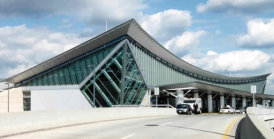
The Niagara Frontier Transportation Authority (NFTA) runs two airports: Buffalo Niagara International Airport and Niagara Falls International Airport. Most people flying to or from Buffalo use the Buffalo Niagara International Airport. This airport is located in a nearby town called Cheektowaga.
The Buffalo Niagara International Airport was rebuilt in 1997. It serves over 5 million travelers every year. This airport is known for being one of the most affordable airports to fly from in the United States. In 2013, the average round-trip flight cost was about $295.
Many Canadians started flying from Buffalo in the 2010s. This was because it was often cheaper due to lower taxes and airline fees compared to Canadian airports. Also, some discount airlines, like JetBlue Airways and Southwest Airlines, fly from Buffalo but not from Canada. In 2006, U.S. Senator Charles Schumer had plans to turn the Niagara Falls International Airport into a major hub for cargo (goods) traveling between New York, Toronto, and Canada.
Getting Around with Public Transit
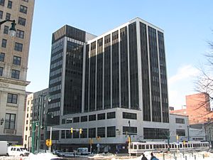
The Buffalo Metro Rail is a light rail system in Buffalo. It is also run by the NFTA. The single train line is about 6.4 miles (10.3 kilometers) long. It goes from Erie Canal Harbor downtown to the University Heights area in the city's northeast.
The part of the train line that runs through downtown is above ground. It is free for passengers to ride. North of Theater Station, the line goes underground. It stays underground until it reaches the end of the line at University Heights. Passengers need to pay a fare to ride this underground section.
The NFTA is working on a project called "Cars Sharing Main Street." This project will change how the Metro Rail works downtown. It will allow cars and Metro Rail trains to share Main Street. This is similar to how trolleys work in San Francisco. The plan includes new stations and improvements to make the area better for people walking. The first part of this project was finished in 2009. The NFTA also operates many bus lines throughout Buffalo and its surrounding areas. The second part of the project was completed in January 2015.
Traveling by Train
Buffalo has one Amtrak train station for travel between cities. It is called Buffalo–Exchange Street station and was rebuilt in 2020. The eastern suburbs of Buffalo also have a station called Buffalo–Depew station in Depew, New York. This station was built in 1979.
Historically, Buffalo was a very important stop for trains traveling between Chicago and New York City. Many different railroad companies used to have stations in Buffalo. For example, the Pennsylvania Railroad ran trains between Buffalo and Washington, D.C.
Today, freight (goods) train services in Buffalo are handled by companies like CSX Transportation and Norfolk Southern (NS). Canadian railroads like Canadian National (CN) and Canadian Pacific (CP) also operate here. The area has four large rail yards where trains are sorted and stored.
Waterways and Harbors
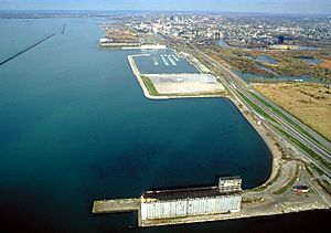
Buffalo is located at the eastern end of Lake Erie, one of the Great Lakes. Lake Erie is famous for having many different kinds of freshwater sport fish. The lake is also a popular place for personal boats, sailboats, and other watercraft.
The city has a large system of walls called breakwalls. These walls protect Buffalo's inner and outer harbors on Lake Erie. These harbors are kept deep enough for large cargo ships called Lake freighters. The Buffalo River and Buffalo Creek are waterways that flow through south Buffalo and into Lake Erie.
Buffalo has a strong connection to the famous Erie Canal. The canal used to end where the Black Rock Channel meets Lake Erie, at Buffalo Creek. When the Erie Canal opened in 1825, New York State governor DeWitt Clinton celebrated by pouring water from Lake Erie into the Atlantic Ocean in New York City. He sailed there on a canal boat called the Seneca Chief. The canal was once a main route for people and goods. It helped open up the American West for settlers from the east. Today, the canal is mostly used for pleasure boats and some local cargo.
Streets and Highways
Several major roads and highways pass through Buffalo. New York State Route 5, also known as Main Street, enters the city from Lackawanna. It connects with Interstate 190, which runs north and south. Interstate 190 connects to Interstate 90 in the suburb of Cheektowaga and goes to Niagara Falls.
NY 354 (Clinton Street) and NY 130 (Broadway) are east-to-west roads. They connect south and downtown Buffalo to eastern suburbs like West Seneca and Depew. NY 265 (Delaware Avenue) and NY 266 (Niagara Street and Military Road) both start downtown and end in the city of Tonawanda.
U.S. 62 (Bailey Avenue) is a major north-to-south road. It enters Buffalo from Lackawanna and leaves at the Amherst town border. This road passes through industrial areas and busy neighborhoods. It has important intersections with Interstate 190 and the Kensington Expressway.
Three main expressways serve Buffalo:
- The Scajaquada Expressway (NY 198) connects Interstate 190 to New York State Route 33. It follows Scajaquada Creek and provides access to the Buffalo Zoo.
- The Kensington Expressway (NY 33) starts near downtown. It goes through busy parts of the city and connects with Interstate 90. It also provides access to the Buffalo Niagara International Airport.
- The Peace Bridge is a major international crossing. It connects Fort Erie, Ontario in Canada with Buffalo.
Main Street's Importance
Main Street runs for 6.5 miles (10.5 kilometers) from downtown Buffalo to the University at Buffalo south campus. About 5.2 miles (8.4 kilometers) of Main Street are part of NY 5.
Main Street is like the backbone of the city. It divides Buffalo into east and west sections. Main Street goes through many well-known areas of Buffalo. These include the Central Business District, the Theater District, Allentown, Central Park, and the University at Buffalo. For many years, Main Street has also marked the difference between wealthier, mostly white neighborhoods on the west side and poorer neighborhoods with more people of color on the east side.
Just north of the city, Main Street goes through the town of Amherst, a large suburb of Buffalo. The road then travels east through other towns like Harris Hill and Batavia, until it ends in Caledonia.
 | Leon Lynch |
 | Milton P. Webster |
 | Ferdinand Smith |


