
Tropical Storm Arthur (2020) facts for kids
| Tropical storm (SSHWS/NWS) | |

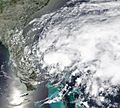
Arthur at its strongest near North Carolina on May 18
|
|
| Formed | May 16, 2020 |
|---|---|
| Dissipated | May 21, 2020 |
| (Extratropical after May 19) | |
| Highest winds | 1-minute sustained: 60 mph (95 km/h) |
| Lowest pressure | 990 mbar (hPa); 29.23 inHg |
| Fatalities | None |
| Damage | $112,000 (2020 USD) |
| Areas affected | Cuba, South Florida, The Bahamas, North Carolina, Bermuda |
| Part of the 2020 Atlantic hurricane season | |
Tropical Storm Arthur was a strong storm that formed in May 2020. This was unusual because the official hurricane season starts in June. Arthur was the first named storm of the 2020 Atlantic hurricane season. This made 2020 the sixth year in a row that a tropical cyclone formed in the Atlantic Ocean before June.
Arthur started as a large area of stormy weather near Cuba on May 14. This weather system slowly moved towards Florida for two days. It then became a tropical depression (a weak tropical storm) on May 16, north of The Bahamas. The next day, it became strong enough to be named "Arthur." Arthur then moved north towards North Carolina. It later weakened as it moved towards Bermuda.
Tropical Storm Arthur brought rain to Florida and caused big ocean waves. Near North Carolina's beaches, Arthur's outer parts caused strong winds and rain. It also created dangerous rip currents along the southeastern coast of the United States.
Contents
Arthur's Journey

On May 12, the National Hurricane Center (NHC) first thought a tropical storm might form near Cuba. By May 13, there were many thunderstorms in Cuba. The NHC said there was a good chance a tropical storm would form soon.
The NHC officially named it Tropical Depression One on May 16. They called it "tropical" because of how the storm's winds spun around its center.
Early on May 17, the NHC named the system Tropical Storm Arthur. This happened after people on an airplane measured its strong winds. Arthur mostly moved north into the Atlantic Ocean. It stayed away from Florida and Georgia.
Arthur then moved northeast over colder waters. Even though the water was cold, Arthur still got stronger. Its center moved very close to the coast of North Carolina, near Cape Hatteras. After that, Arthur moved away from North and South Carolina. It started to look less organized.
However, the storm continued to get stronger for a short time. Early on May 19, Arthur had its lowest air pressure and strongest winds. Its winds reached 60 miles per hour (95 km/h). Six hours later, the storm was no longer tropical. Arthur finally disappeared on May 21, five days after it first became a depression.
What Arthur Did
In the Caribbean
Arthur brought a lot of rain to Cuba on May 15. Some parts of Cuba got almost 3 inches of rain in just four hours. This rain damaged homes and flooded streets.
Arthur also caused some damage in the Bahamas. This area had been hit hard by Hurricane Dorian the year before. Arthur caused floods and blew away tents. Many people were living in these tents while rebuilding their homes. Luckily, Arthur's strongest winds stayed over the ocean. This meant fewer buildings were damaged.
In the United States
Florida's Experience

Arthur was not yet a tropical storm when it reached Florida. It was still a developing weather system. Still, Arthur dropped a lot of rain and wind on Florida on May 13 and 14. Some areas got over 4 inches (101.6 mm) of rain. One city had its tenth highest rainfall ever on May 14.
Flash flood warnings were put out for parts of Miami-Dade County. In Miami, streets became flooded from the rain. Strong winds made officials issue gale warnings for boats in South Florida. Seventy people in Volusia County needed to be rescued from dangerous rip currents. Three of them had to go to the hospital.
Flags were raised along the coasts of Georgia and South Carolina. These flags warned people about the rip currents. Offshore Georgia, waves were 3 to 6 feet (0.9-1.8 m) high. Arthur caused about $112,000 in damage in Florida.
North Carolina's Experience
Arthur reached North Carolina as a tropical storm. On May 16, tropical storm watches were put in place. These watches covered areas from Surf City to Duck, and Pamlico Sound to Albemarle Sound. A day later, these watches became tropical storm warnings as Arthur got closer to the Outer Banks.
By late May 17, the ocean water in the southern Outer Banks became dangerous. Very heavy rain fell as Arthur's outer rainbands moved over eastern North Carolina. One town, Newport, got almost 5 inches (125 mm) of rain in six hours. Many other places got at least 3 inches (75 mm) of rain.
Tropical storm-force winds were recorded in Cape Hatteras. However, the strongest winds mostly stayed over the ocean. This was because Arthur was an uneven storm. Waves as high as 12.5 feet (3.8 m) were seen along the Outer Banks coast.
Because of flooding from Arthur, many highways in the Outer Banks and mainland North Carolina were closed. SpaceX also had to delay launching some Starlink internet satellites. This was due to bad weather from Arthur. As Arthur moved away from land, all warnings were canceled.
Other Places in the United States
In James City County, Virginia, some areas near the ocean saw flooding. In south New Jersey, Arthur caused floods, even though it was not a tropical storm there. There were also strong winds on the Jersey Shore. Power lines were blown down. Trees had fallen on the Atlantic City Expressway and other roads.
Related pages
Invalid <references> tag; parameter "group" is allowed only. Use <references />, or <references group="..." />
Images for kids
-
Tropical Depression One affecting Florida on May 16.

See also
 In Spanish: Tormenta tropical Arthur (2020) para niños
