
Tuna Canyon facts for kids
Quick facts for kids Tuna Canyon |
|
|---|---|

Tuna Canyon
(photo center (right border)) |
|

Tuna.Canyon
Location in Arizona
|
|
| Floor elevation | 2,297 ft (700 m) |
| Length | ~3.5 mi south-north, then northeast |
| Geology | |
| Age | Permian down to Cambrian (central Lower Canyon, gorge)-Proterozoic Vishnu Basement Rocks |
| Geography | |
| Location | (west)-Grand Canyon, (northern)-Arizona, United States |
| Borders on |
List
|
| Topo map | Havasupai Point, USGS |
| Rivers | Tuna Creek |
Tuna Canyon is a small, steep canyon located in the western part of the Grand Canyon in Arizona, USA. It sits below the North Rim, which is the northern edge of the Grand Canyon. The canyon is carved by Tuna Creek, which flows into the Colorado River.
Tuna Canyon is found in an area where the Colorado River makes its way west around two important ridgelines: Point Sublime and Grama Point. Because Tuna Creek flows steeply down the canyon, it creates a fast-moving section of water called the Tuna Creek Rapids where it meets the Colorado River. Even though Tuna Canyon is short, it is very close to Crystal Creek (Arizona), a much longer waterway that starts far away on the Kaibab Plateau. The Crystal Rapid is just upstream from Tuna Creek Rapids on the Colorado River.
Tuna Canyon is about 1.5 miles northeast of a landform called Scorpion Ridge, which is also along the Colorado River. Point Sublime is located directly south of the canyon's lower part. The very top of Tuna Canyon, called its headwaters, is about 2 miles northeast of Point Sublime, near Grama Point. The total length of Tuna Canyon is more than 3 miles.

Contents
What Landforms Surround Tuna Canyon?
Tuna Canyon is surrounded by several large natural features and two famous viewing spots. On its eastern side, you'll find the large mountains of Mencius Temple and Confucius Temple. These are connected to Grama Point, which is to the northeast. Grama Point also looks over South Crystal Canyon, a major branch of the Colorado River to the east.
To the north of Tuna Canyon, you can see Point Sublime to the west. Further east are two other points, with Grama Point being the farthest east. The western edge of Tuna Canyon goes up a small valley west of Point Sublime. This small valley is next to the large Sagittarius Ridge. Scorpion Ridge is connected to Sagittarius Ridge to the southwest.
What are the Tuna Creek Rapids?
.jpg)
The Tuna Creek Rapids are located at Mile 99 along the Colorado River. Just upstream, at Mile 98, you'll find the Crystal Rapid, which is a larger and more famous rapid.
What is the Geology of Tuna Canyon?
The floor of Tuna Canyon has a gentler slope compared to the dramatic cliffs that rise from the points to the north and the large mountains of Mencius and Confucius Temples to the east and northeast.
Some rock layers in the Grand Canyon, like the Redwall Limestone, form both tall cliffs and flat platforms. The Redwall Limestone is actually gray, but it looks red because of the red-orange rocks of the Supai Group above it, which stain it. This upper platform of the Redwall Limestone is very common in the canyon and supports many named landforms. Below the Redwall Limestone is another rock layer called the Muav Limestone, which also forms a short cliff and a platform. This means the Redwall and Muav Limestones together create a "double-platform" feature.
Here's a simple look at the different rock layers found in Tuna Canyon:
Rock Layers in the North Cliffs
- Permian Period
- Kaibab Limestone: This rock layer is mostly flat and forms the top of Grama Point.
- Toroweap Formation
- Coconino Sandstone
- Hermit Shale
- Cambrian to Pennsylvanian Periods
- Supai Group: This group of rocks includes several layers.
- Esplanade Sandstone: Part of the Supai Group.
- Pennsylvanian Period
- Other Supai layers: Wescogame, Manakacha, Watahomigi.
- Mississippian Period
- Cambrian Period
Rock Layers in the Valley Floor and Gorge
- Cambrian Period
- Neoproterozoic Era
- Vishnu Basement Rocks or Unkar Group: These are some of the oldest rocks in the Grand Canyon.
Images for kids
-
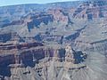
South of Granite Gorge: Marsh Butte and Slate Canyon (lower canyon). North: Scorpion Ridge, Sagittarius Ridge, Point Imperial, and Tuna Canyon.
-
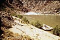
View looking down-river from the left bank at Mile 99.1.
-
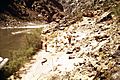
View looking down-river from the right bank, showing Tuna Creek at Mile 99.1.
.jpg)
.jpg)
.jpg)
Reflist
