
Wescogame Formation facts for kids
Quick facts for kids Wescogame FormationStratigraphic range: Upper Pennsylvanian, 312–300Ma |
|
|---|---|

Representative Supai Group 'redbeds'
(ridgeline extending north from South Rim, Grand Canyon) |
|
| Type | Geologic unit |
| Unit of | Supai Group |
| Underlies | Esplanade Sandstone, (4th member)-Supai Group |
| Overlies | Manakacha Formation, (2nd member)-Supai Group-312 Ma |
| Thickness | 200 feet (61 m) max (100-200 ft typical) |
| Lithology | |
| Primary | sandstone, siltstone |
| Location | |
| Region | Colorado Plateau, southwest and south |
| Extent | Grand Canyon, Verde Valley, and basement rocks of Mogollon Rim and central & east-northeast Arizona |
The Wescogame Formation is a special layer of rock found in the Grand Canyon in Arizona. It formed during the late Pennsylvanian Period, which was about 312 to 300 million years ago. This rock layer is mostly made of red-orange sandstone and siltstone.
Imagine a time when the Grand Canyon area was covered by a shallow sea. The Wescogame Formation formed from sand blown by the wind (eolian sand) mixing with mud and silt left behind by the ocean. It's known for forming gentle slopes in the landscape.
The Wescogame Formation is part of a larger group of rocks called the Supai Group. This group is famous for its reddish colors, which is why they are often called 'redbeds'. You can find the Supai Group not just in the Grand Canyon, but also in other parts of Arizona, like the Verde Valley.
Contents
Layers of the Grand Canyon
The Grand Canyon is like a giant history book made of rock layers. The Supai Group is one of the important chapters. Here are the main rock layers that make up the Supai Group, from oldest to newest:
- Supai Group
- 1- Watahomigi Formation
- 2- Manakacha Formation
- 3- Wescogame Formation (This is the layer we are talking about!)
- 3B- Pakoon Limestone (found mostly in the western Grand Canyon and Nevada)
- 4- Esplanade Sandstone (Early Permian Period)
These layers formed as the ocean levels changed over millions of years. Sometimes the sea covered the land (called a marine transgression), and sometimes it pulled back (called a regression). This is why you see different types of rock, like sandstone (from beaches or sand dunes) and siltstone (from muddy ocean floors), mixed together.
Ancient Landscapes and Seas
Millions of years ago, the land that is now Arizona was very different. The ocean was to the west of what would become North America. Rivers and winds carried sand and mud from ancient mountains and land areas into these seas.
For example, the ancient Antler Mountains in what is now Nevada supplied some of the material. Other sediments came from the east. All these materials settled in ancient basins, which were like big dips in the land that collected sediment.
Comparing Rock Layers Across States
Similar rock layers formed at the same time in different places. For example, the Supai Group in Arizona is similar to the Hermosa Group found in Utah and Colorado. Even though they have different names, they formed around the same time and tell us about the ancient environment.
Here's a simple look at how they compare:
| Arizona — Grand Canyon & central-northeast AZ |
Utah — east & southeast | Ancient Mountains (Uncompahgre Uplift) |
Northwest Colorado Northeast Utah |
|---|---|---|---|
| Supai Group ~340 to 285 million years ago |
Hermosa Group | "Ancestral Rocky Mtns" (eroded by 165 million years ago) |
Hermosa Group |
| 4-Esplanade Sandstone | Cedar Mesa Sandstone | "Ancestral Rocky Mtns" | xxxxxxx |
| 3B-Pakoon Limestone | Elephant Canyon Formation | "Ancestral Rocky Mtns" | Hermosa layers? |
| 3-Wescogame Formation | (Hermosa) | "Ancestral Rocky Mtns" | Hermosa layers? |
| 2-Manakacha Formation | (Hermosa) | "Ancestral Rocky Mtns" | Hermosa layers? |
| 1-Watahomigi Formation | (Hermosa) | "Ancestral Rocky Mtns" | Hermosa layers? |
| Ancient Mountains |
These layers might look a bit different because of local conditions. Things like how much the land sank or rose, or even changes in sea level due to ice ages, could affect what kind of sediment was laid down.
-
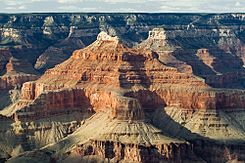
Wescogame Formation slopes are visible directly below the tall cliff of Esplanade Sandstone. This is at Isis Temple, showing the full Supai Group.
-
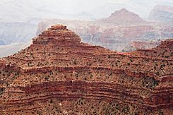
A close-up view of the 'redbeds' rock layers.


Fossil Footprints
The Wescogame Formation and other nearby layers are famous for something very cool: fossil footprints! These ancient tracks tell us about the animals that lived here millions of years ago.
The first fossil footprints in this area were found in 1915 by a scientist named Charles Schuchert. Later, in the 1920s, another scientist named Charles Gilmore visited the Grand Canyon. He collected many of these footprints for the Smithsonian Institution. He even wanted to create a special exhibit at Hermit Trail to show off these amazing tracks from the Paleozoic Era.
Gilmore was very successful. He published several papers about the footprints he found, including those from the Early Permian Hermit Formation and the Middle Permian Coconino Sandstone. These footprints give us clues about the creatures that walked across this land long, long ago.
