
Twyford Down facts for kids
Quick facts for kids Twyford Down |
|
|---|---|

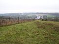
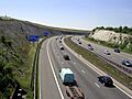
Twyford Down in November 2005, with the M3 in the background
|
|
| Highest point | |
| Elevation | 142 m (466 ft) |
| Listing | (none) |
| Geography | |

Twyford Down
Location in Hampshire
|
|
| Location | South Downs, England |
| OS grid | SU506275 |
| Topo map | OS Landranger 185 |
Twyford Down is a beautiful area of chalk downland in Hampshire, England. It is located southeast of Winchester, right next to St. Catherine's Hill. This special place is also very close to the South Downs National Park.
People have lived on Twyford Down since before Roman times. It has been home to an old fort and a chapel. In the 17th and 18th centuries, it was even a route for horse-drawn coaches.
In 1991, Twyford Down became famous for a big road protest. People were against building a part of the M3 motorway through this area. Plans for this motorway had existed since the 1970s. The goal was to replace an old road from the 1930s that was always busy.
Building the road was tricky because there wasn't much space. It was between Winchester College and St. Catherine's Hill. After many public meetings, a route was chosen. It would take the motorway through the down in a deep cut. Protests against the M3 had been happening since the 1970s. But the protest at Twyford Down brought together many different types of people. It became one of the most talked-about motorway projects in Britain.
The motorway was finished as planned. It now connects London to the south coast ports. However, the protests got a lot of attention from the news. They showed how powerful this kind of campaigning could be. After Twyford Down, new road plans started to consider the environment more. Some projects were even cancelled. Many protesters from Twyford Down went on to form new groups. Others joined existing ones like the Campaign for Better Transport.
Contents
History of Twyford Down
Twyford Down is located southeast of Winchester. It is also northeast of the village of Twyford. The down is part of a larger area called the Winchester-East Meon Anticline. The highest point, Deacon Hill, is 142-metre (466 ft) tall. It is on the northeastern side of the area. Twyford Down is known for its rolling hills and rich grasslands.
Its history goes back more than 3,000 years. Old paths called "dongas" cross the down. Farmers used these paths to move animals to markets. St Catherine's Hill, in the middle of the down, was a human settlement long ago. It existed even before Winchester was founded.
Around the 3rd century, a fort was built on the hill. Later, in the 12th century, a Norman chapel was built there too. During the Middle Ages, paths on the down were part of the Pilgrim's Trail. This trail went from Winchester to Normandy through Portsmouth. Today, a modern Pilgrims' Trail still crosses the down.
In 1675, a mapmaker named John Ogilby noted something important. The main coaching route from London to Southampton went over Twyford Down. It went straight from Alresford to Twyford. This route avoided Winchester completely. It stayed the main coaching route until about 1800. Then, a new route through Winchester was created. This new route is now mostly the A31 and part of the old A33.
For a time, up to the 19th century, the area was sometimes called Morestead Down. This was after the nearby village of Morestead. Hockley Golf Club opened on the down in 1914. It was a private club for its members.
The M3 Motorway Extension
Why a New Motorway?

Plans for the M3 motorway began in the late 1930s. The idea was to connect London to Basingstoke. This would help reduce traffic on the A30. Detailed planning for the first part of the motorway started in 1962-63. This section was 40 miles (64 km) long. It ran between Sunbury on Thames and Popham.
The part between Lightwater and Popham opened in June 1971. This was a 26 miles (42 km) section. The Sunbury to Lightwater section opened in July 1974. The next part of the motorway was to extend 10 miles (16 km) south. It would go from Popham to Winchester, ending at Compton. Planning for this began with a public inquiry in 1971. This inquiry decided where the motorway would go. This second section opened in 1985.
The final part of the plan was to extend the motorway from Winchester to Southampton. It would connect to the M27 motorway. The northern part of this section would affect Winchester's bypass.
Winchester had traffic problems for many years. Several main roads went through the old city center. These included the A31, A33, and A34. Smaller roads like the A272 also added to the congestion. In the 1930s, a bypass was planned east of the city. It would pass west of St. Catherine's Hill. This bypass opened on February 1, 1940.
Building this road was controversial. It affected the Itchen Valley. Also, it only partly solved the traffic problem. Some people wanted a bypass to the north and west of Winchester instead.
The 1930s bypass was built to old standards. It had crossings at Bar End and Hockley where roads met at the same level. Over time, this bypass became a major bottleneck. Other roads around it were improved. After the A33 Chandler's Ford Bypass opened in 1968, all long-distance traffic used the Winchester bypass. Morgan Morgan-Giles said the bypass was "utterly inadequate and dangerous." He noted that accident numbers were "appalling."
The crossing at Bar End was improved in 1973. It was changed so roads passed over or under each other. But the junction at Hockley remained a key point for traffic jams.
Public Meetings and Decisions
At first, building over or through Twyford Down was not considered. The planned six-lane M3 motorway was to go through the Itchen valley. This was west of the existing four-lane bypass. This plan would also require moving the Itchen Navigation into the water meadows. However, there would be more trees to hide the motorway. Also, people could walk from the city to St. Catherine's Hill.
These plans went through two public inquiries. One was in 1971, and another in 1976. The first inquiry looked at the proposed route of the motorway. In 1973, the government approved this route. The second inquiry in 1976 looked at closing side roads. It also considered buying land needed for the motorway. This second inquiry faced strong opposition from protesters. Some teachers from Winchester College were among them.
Morgan-Giles spoke in Parliament to support the plan. He said Winchester and the Down were already cut off by the old bypass. He also noted that Southampton Docks were growing. This meant better links from London and the Midlands were needed. But this plan was eventually rejected. This was because of increasing pollution and disturbance to the local area.
In 1981, Kenneth Clarke, a government transport official, said something new. He stated that the M3 route was set as far as Bar End. This was north of St. Catherine's Hill. But the route from there to Compton would be studied again. He specifically said the Winchester Bypass should stay open while any new road was built. He also stressed that environmental issues were very important.
By February 1983, engineers suggested completing the M3 through Twyford Down. The motorway reached Bar End in the summer of 1985. After that, the Hockley junction was the only traffic light between London and Southampton.

The Ministry of Transport had trouble buying the land. This land was needed to finish the road past Winchester. The land was east of the city on Twyford Down. It was owned by Winchester College. The college refused to sell the land. This was because part of it was a water meadow.
The desired route was chosen to avoid St. Catherine's Hill. It would pass to the south. Some people suggested a tunnel through Twyford Down. But this would cost £75 million more than a cutting. The government rejected the tunnel idea. The final route went south of St. Catherine's Hill. It took about 4.5% of a Site of Special Scientific Interest (SSSI). This plan went to a public inquiry in 1985. The Planning Officer for Winchester City Council called the route "bold" and "imaginative."
In February 1992, the M3 was improved between Southampton and Compton. Soon after, work began on clearing the route across the down. Part of the agreement was to remove the old bypass. It would be returned to nature. This would restore direct access to St. Catherine's Hill.
The Protests Begin
Protests against finishing the M3 had been going on since 1973. The M3 Joint Action Group was formed by David Pare. This group collected a petition with 19,000 signatures. Over 11,000 of these were from Winchester residents. The group also gave out leaflets to local people.
In March 1992, two travellers set up camp on the down. They learned from local ramblers that the land would soon be dug up. They realized that public inquiries had failed to stop the road. So, they decided to gather support.
Environmental groups tried to take the Department for Transport to court. They said the road went against the government's own environmental laws. But the European Commission dropped its objections in August. David Croker, who led the Twyford Down Association, said they were "very disappointed." They had relied on the European Commission.
The main reasons for the protests were several. People worried about losing wildlife, like the Chalkhill Blue butterfly. They also feared a big, ugly scar on the landscape. And they believed the new motorway would not truly fix traffic problems.
Protesters showed their opposition by blocking construction equipment. They were met by security officers from Group 4. The protest attracted many different kinds of people. Most of them were peaceful. A common saying among protesters was, "I never thought that I would find myself doing something like this."
Stephen Ward had been part of the original 1970s protest. In early 1993, he felt too much force was used against protesters. He started keeping a record of events. He used this record to defend other protesters in court. He visited those who were in prison. He also helped set a legal rule. This rule said protesters have the right to have a witness when questioned.
What Happened Next?

In 1995, the motorway section through Twyford Down opened. This made the M3 a continuous motorway. The old A33 Winchester Bypass was then closed and removed. The new cutting caused the loss of about 1.91 hectares (4.7 acres) of special SSSI land.
To make up for this, the old A33 route was replanted. It was given 7.2 hectares (18 acres) of grassland with many different plant species. This was watched over by the Institute of Terrestrial Ecology. Removing the bypass also reduced traffic in Twyford village. It also removed the road that separated St. Catherine's Hill from the city.
When interviewed, local residents said this change was amazing. One person said, "St. Catherine's Hill used to be cut off from Winchester by the A33. Now there's open, peaceful countryside. It's wonderful."
After the Twyford Down cutting was built, road construction in the UK slowed down. In 1994, a government group said that building more roads would just mean more traffic. They said the way to ease traffic and pollution was to control car use. When the Labour party came to power in 1997, many road plans were cancelled.
In 2000, campaigners took legal action. They wanted to protect a grassland area. This area was created on the old A33 bypass route. It was meant to make up for the land lost to the motorway. But this grassland was threatened by a Park and Ride site. The legal action failed. Campaigners felt they had been let down again. Other land was provided elsewhere to make up for it.
In 2004, Winchester Cathedral received £86,000. This was from the Highways Agency. It was compensation for more traffic noise from the M3. The Rev. Michael Till explained that "the noise comes beaming straight across The Close." He added that "it does change life having a perpetual background noise."
Also in 2004, some Twyford Down protest veterans threatened new protests. This was in response to 200 new road-building plans. These plans were in the government's ten-year transport plan. Rebecca Lush later founded Road Block in 2005. This group became part of the Campaign for Better Transport in 2007.
Chris Gillham, a veteran road protester, believes his efforts helped. He actively confronted security officers at Twyford Down. He also crawled under razor wire. He thinks his actions helped later road projects. For example, the Hindhead Tunnel was planned with more care for the environment. In 2012, some original protesters returned to the down. They held a celebration for the 20th anniversary of the protest.
Twyford Down became part of the western edge of the South Downs National Park in 2011. Before that, it was part of the East Hampshire AONB (Area of Outstanding Natural Beauty).
Images for kids
-
Twyford Down in November 2005, with the M3 in the background
-
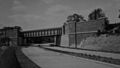
The original A33 Winchester Bypass, built in the 1930s, was not good enough for modern traffic.
-
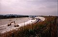
The Twyford Down cutting during M3 construction in July 1994.
-
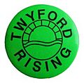
"Twyford Rising": A button badge worn by supporters of the Twyford Down road protest. Stencil-painted versions of this logo appeared around Winchester.
-
The Twyford Down cutting in August 2005.
